Geoff Walden


Home ] Table of Contents ] Updates ] Berchtesgaden ] Berlin ] Buchenwald ] Chiemsee Autobahn Rasthaus ] Adolf Hitler Visits Austria ] Adolf Hitler Visits Czechoslovakia ] Ebensee ] Flossenburg KZ Site ] Garmisch ] Mauthausen ] Gusen/Bergkristall ] Auschwitz-Birkenau ] [ Th�ringen ] Mittelwerk/Dora ] Munich ] Dachau Concentration Camp ] Tegernsee ] N�rnberg ] Muehldorf ] Thingplatz ] End of the War in the Main-Spessart ] s.Pzjr.Abt. 653 ] Schweinfurt ] Miscellaneous Sites ] Wolf's Lair ] Mauerwald ] Anlage Mitte ] Prora KdF Resort ] Project Riese (Giant) ] U.S. Army Posts ] Nazi Eagles ] Wehrmacht Kaserne ] Hitler Visits Vienna ] Ordensburg Vogelsang ] Weimar / Dresden ] W�rzburg ] Haus der Deutschen Kunst, Part 1 ] Lost Sites ] German War Memorials ] Cold War Sites ] Links ]


Underground Sites in Th�ringen (Thuringia)

   As Allied bombing of the Reich resulted in increased destruction of critical factory areas and disruption in manufacture of Hitler's "Wonder Weapons," the Nazis began to move these and other critical sites underground. The state of Th�ringen proved ideal, as it was located in central Germany (furthest from the advancing enemy forces) and had an abundance of deep wooded valleys and rugged terrain (difficult to invade), plus it had several tunnel mines already dug into hillsides, which only required enlarging to use as military facilities.

   One of the best known of these sites (of course, it only became generally known after the war) was the Mittelwerk near Nordhausen, where V-1 and V-2 rockets were made by slave laborers from concentration camps, deep inside a mountain factory. This site is covered on a separate page.

   This page shows three other sites in central Th�ringen: an underground factory for the Me 262 jet aircraft near Kahla, a tunnel system that was started in the Elster valley at Berga, and an underground facility that may have been meant for the final F�hrerhauptquartier (FHQ) near Gotha.


REIMAHG Me 262 Production Site near Kahla (Codename "Lachs" - "Salmon")

   One of the most remarkable advancements made by the German military in World War II was the production of turbine-jet aircraft. The most famous of these was the Messerschmitt Me 262, developed beginning in 1938 and fielded in 1944. A special production facility was started in 1944, for quicker assembly line manufacture. Due to the setup at the main Messerschmitt factories, fast assembly line production was not possible, and these sites were vulnerable to Allied bombing. Accordingly, a company called Flugzeugwerke Reichsmarschall Hermann G�ring (REIMAHG for short) was formed as a subsidiary of the Gustloff Nazi industrial complex. REIMAHG eventually became concerned only with the Me 262, and its main production facility was located in an old sand mine for porcelain production in the Walpersberg Hill near Kahla (south of Jena) --   Codename "Lachs" ("Salmon").

   The existing tunnels in the Walpersberg were enlarged and others were dug, and massive concrete bunkers were built outside these tunnels. Subparts were made and partially assembled in the tunnels, then moved outside to the concrete bunkers, where final assembly took place. The assembled jets were then moved to the top of the hill via a platform that moved along a railed ramp by a power winch. The top of the Walpersberg had been leveled off and concreted in a massive construction effort, to form a runway some 3300 feet long. This was not sufficient for an Me 262 to take off (even with the jet engines, take-off was actually fairly slow), so small rockets assisted take-off. The runway was also too short for the jets to land, so leaving the Walpersberg was an all-or-nothing proposition: there could be no emergency landings. The jets were flown from Kahla to a site some 130 kilometers away to be fitted with weapons and radios, and to undergo final testing.

   REIMAHG only managed to produce some twenty-seven Me 262 jet fighters by the end of the war. The work was done mostly by foreign forced laborers, some 991 of whom died during their nine months at "Lachs." The U.S. Army took the site on 12 April 1945, and before turning Th�ringen over to the Soviets in July, they removed enough parts to finish five Me 262s that were found on the production line. Surprisingly, the Kahla area had not been bombed. British Intelligence had photographed Me 262s at the site in March 1945, so the Allies were well aware of "Lachs." But Kahla was spared the fate of the V-2 works at Nordhausen, which suffered a devastating bombing attack only eight days before the American Army arrived. (In spite of this historical report, the REIMAHG-Kahla site today shows many depressions that look very much like bomb craters that can be seen at such sites as Normandy and the Obersalzberg, and many areas that appear to have undergone explosive upheaval, all in areas that were flat during the war. This situation is apparently the result of Soviet activity after the war.)

   Beginning in 1947, the Soviets blew up the concrete bunkers and assembly buildings, and also the entrances to most of the tunnels, including destruction of the concrete runway on the hilltop. However, the concrete buildings had reinforced walls some 10 feet thick, so in many cases, the explosions only collapsed the roofs. REIMAHG-Kahla remains today one of the most extensive Third Reich ruins sites, with the walls and foundations of most of the concrete assembly and workshop buildings, some still supporting parts of their roofs. The site and bunker ruins can now be visited by the public - see www.reimahg.de.

Click here for a Google Maps � map showing the location of this site.


REIMAHGaerial1a.jpg (106568 bytes)

Part of an aerial view of the site, taken by British photo-reconnaissance on 19 March 1945. The Walpersberg with its hilltop runway is at the top. A tiny Me 262 can be seen just at the top of the ramp, beside the runway. Various bunkers and assembly buildings can be seen along the cleared area at the bottom of the slope, to the right of the ramp bottom. The dark blotches on the runway, to the right of the ramp, were an incomplete attempt at painted camouflage. (Combined Intelligence Objectives Sub-committee (CIOS) - Underground Factories in Central Germany, London, 1945)

Walpersberg.gif (31781 bytes)

Artist's concept of the site, based on the aerial photographs. The massive concrete bunkers can be seen along the bottom of the slope. The large buildings ran from east-west (right-left): Bunker 4, Hall 3, Bunker 1, Workshop 1, Bunker 0, Workshop 2, Bunker2. Just to the left of Bunker 2 was the bottom of the ramp for lifting the finished aircraft up the slope to the runway on top of the hill. (Note: This page uses the bunker numbering scheme shown in the 1945 CIOS Report, which differs somewhat from modern references.)  (from Joan David, "Sky Spies," in Flying, Vol. 37 (1945), page 42)

Partial view of the REIMAHG site today, as seen from the southeast. The large concrete bunker seen on the right, above the village of Gro�eutersdorf, was Bunker 4. This long bunker can be seen near the right side of the site drawing above. Further remains can be seen to the left in this photo.


Compare this 1945 photo of Bunker 4 to a similar view of the remains of Bunker 4 today. The roof has been collapsed, and only parts of the front and back walls remain. The photos below show the state of the ruin of Bunker 4 today. Bunker 4 was the largest, measuring some 100 meters long and 15 meters wide, and it is the largest ruin remaining at the REIMAHG site. The fuselage of the Me 262 was assembled in Bunker 4.  (National Archives, RG 111-SC 203644)   Note: Some modern sources call this Bunker 1, but the 1945 CIOS Report refers to this building as Bunker 4.


The original entrances to the tunnel system were outside the assembly hangers. Entrances directly into the hillside were later added in some of the assembly bunkers. This was Entrance I, to the right of Bunker 4, which led into the old porcelain sand mine part of the tunnel system. The entrance was filled in and covered over years ago.  (National Archives, RG 111-SC 203643)


The rear wall of Bunker 4 shows the former entrance to one of the tunnels going back into the hillside. The assembly bunkers were originally wooden hangars, which were later covered by reinforced concrete some 3 meters (10 feet) thick.

A memorial has been placed on the side of Bunker 4 by the Association for the Preservation of the History of REIMAHG, to honor the memory of the forced laborers who worked and died there.


Nearby is the only original tunnel entrance that remains unburied today, an entrance into the old porcelain sand mine. Ventilation pipes run inside this tunnel today.


Hall 3 (next to Bunker 4) was the Windenhaus, a building housing a winch system to draw rail cars with supplies up the slope from the rail line in the valley below. The building also had a carpentry shop built over the winch house, which remains as a partial back wall today. Remains of the platform at the top of the winch can also be seen at the edge of the slope in front of the winch house. Ruins of the bottom of the rail car winch system can be seen in the valley below (photos below).


Inside the machinery rooms of Hall 3 Windenhaus.


Bunker 1 was used for wing assembly. It had a sloped roof designed to deflect bombs. Little remains today of Bunker 1 except part of the back wall.  Tunnel entrance IV was in the hillside just to the right of Bunker 1, buried today (below - this is the appearance of most of the buried tunnel entrances today). (Some modern references call this Bunker 4.)  (CIOS Report)


View looking down the row of bunkers, with Bunker 0 at the left edge of the photo, followed by Workshop 1 (the angled building), then Bunker 1 on the right. The only meaningful comparison view that can be made today is a view of the ruins of Workshop 1 (on the right), showing the collapsed doorway that can be seen on the closest side of this building in the period photo. All of the main entrances to these buildings were designed to be closed by sliding armored doors of steel and steel-reinforced concrete. Remains of these doors can be found today on the slope above the ruin of Workshop 1 (photos below). Other such doors can be found further up the slope as well.  (National Archives, RG 111-SC 203642)


Bunker 0, which was built against the hillside, covered the main tunnels 34 and 35, and was the location of final aircraft assembly, as seen in the 1945 photos below. The side entrance to Bunker 0 was closed by a set of huge sliding doors, just to the right of which can be seen the hillside entrance to Tunnel 33 (buried today). On top of the assembly bunker can be seen the two-story assembly hall, office and workspaces. Little remains today of this huge building but part of the back wall and chunks of rubble. The unfinished connecting entrances to Tunnels 34 and 35 can be seen on the back (right) side of the bunker wall in the view on the left below.  (top left - U.S. National Archives film; bottom left - Life Collection; bottom right - U.S. National Archives, RG 111-SC)


This small tunnel in the hillside above the ruin of Bunker 0 is thought to have been either an air raid shelter for the personnel working in the office spaces on top of Bunker 0, or an unfinished ventilation shaft into the tunnel system.  (right - courtesy Ralf Hornberger)


In the foreground is Bunker 2, with its sloped roof designed to deflect bombs, in common with Bunker 1. The next (shorter) building was Workshop 2, and behind it was Bunker 0, which had an additional two stories of offices and living quarters for headquarters staff on its top. Little remains of the front of Bunker 2 but large concrete chunks and foundations, but a large piece of the rear wall remains. Bunker 2 was used for final aircraft tuning, before the completed aircraft were winched up the slope to the runway on the top of the mountain.  (G�nter Sch�rlitz collection)


A short distance outside Bunker 2 was the ramp laid with rails, used to winch the completed aircraft up the slope to the runway at the top of the mountain. The comparison photo was taken further up the slope, as the bottom of the ramp is partially buried today and covered with vegetation. The remainder of the ramp path can be clearly seen today all the way to the top of the slope. The photo below shows some of the original winch cable that can be found at the site.  (Bundesarchiv Koblenz)


At the top of the ramp was a concrete structure housing the winch mechanism. The period view was taken after the war; in use, the large pit in front of the concrete housing was covered over to allow the jets to be pulled over and maneuvered onto the runway apron, seen in the foreground. The two views at the bottom show the slope side - looking up on the left, and looking down the ramp on the right. (U.S. National Archives, RG 111SC)


This view of the apron at the top of the ramp shows the covered winch mechanism at the edge of the slope in the background. A similar view today shows the concrete ruin nearly obscured by the trees that have grown up since 1945. The view below is looking back the other way, showing a flat cleared space where the concrete apron was located.  (U.S. National Archives, RG 111SC)


The top of the Walpersberg Hill was leveled off for a poured concrete runway of some 3900 feet length, some 100 feet wide (see the photos at the top of this page). The runway had a narrow gauge railway running along one side and various buildings and bunkers on the other. After the war the concrete surface was destroyed by the Soviet forces with shaped-charge cratering charges, which left areas of regular shaped pits that can still be clearly seen today (lower left). Trees were planted, and it is difficult to envision an open runway standing on the top today (upper right). Only scattered chunks of the original concrete runway surface can be found today (lower right).  (U.S. National Archives, RG 111SC)


On the south side of the runway, overlooking the aircraft assembly bunker area below, is a small concrete bunker that was the base for an observation tower, and could serve as an air raid shelter.


Nearby, also on the south side of the runway, is the stone foundation of a log house used by Fritz Sauckel, Nazi Gauleiter of Th�ringen, who was responsible for providing the forced labor for various projects, and who was closely connected to the REIMAHG works. Trenches that were probably built for air raid protection were near Sauckel's house and the observation tower. Below - on the opposite (north) side of the runway can be found the concrete top for a winch mechanism that moved goods and material up the slope from the valley below, and also an abandoned excavator shovel near a quarry.


Also on  the north slope of the hill is this large concrete artifact, an armored cover for the top of a ventilation shaft that led down to Tunnel 10 below. This block is tilted today due to Soviet efforts to blow it up.


Two large wooden workshop buildings, Halls 7 and 8, were located in the valley below the bunker buildings. These buildings were used for the repair of machinery. Their concrete foundations remain today - this is the foundation of Hall 7. The Hall 8 ruins are less extensive.


A water reservoir was also found in the valley, below the rail car lift (above left), and other concrete artifacts can be found on the slope above the valley floor (above right - a large piece of a bunker that was blown down the slope when the Soviets blew up the bunkers in 1947).


A standard gauge railway was under construction to serve the REIMAHG site, but it was not completed. Two bridges were built to span the valley below the hillside, and their concrete abutments survive today.


The first group of forced laborers for the REIMAHG construction were housed in the nearby town of Kahla, in the RAD Arbeitsdienstlager Kahla-Th�ringen, which had been converted from the Rosengarten guesthouse. The building, changed very little, again serves as a guesthouse today. A sign in the rear of the building labeled the back as the "Horst Wessel Haus," named for the Nazi hero of the struggle in the late 1920s (see here).  (Kahla Museum)


References:

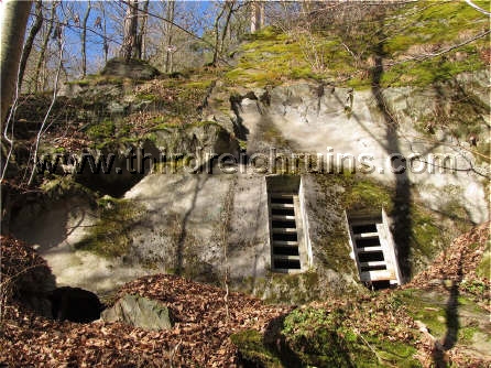
Klaus W. M�ller and Willy Schilling, Deckname Lachs. Zella-Mehlis,  Heinrich-Jung-Verlagsgesellschaft mbH, 3rd Ed., 1996.

Joan David, "Sky Spies," Flying, Vol. 37 (December 1945), pp. 39-42, 106, 108, 111-112.

Markus Gleichmann and Karl-Heinz Bock, D�senj�ger �ber dem Walpersberg. Zella-Mehlis,  Heinrich-Jung-Verlagsgesellschaft mbH, 2009.

For those that can find it, the best source of information in English on the Kahla REIMAHG facility is "Underground Factories in Central Germany," by the Combined Intelligence Objectives Sub-Committee (CIOS), London, 1945 (Item Nos. 4, 5, 25 & 30, File No. XXXII-17; copies in the U.S. National Archives and Imperial War Museum, London).

NOTE - An association has been formed that manages a documentation center in Gro�eutersdorf and gives guided tours of the REIMAHG area. For further information, see www.walpersberg.com

-


Underground Fuel Production site at Berga/Elster (Codename "Schwalbe V")

   In late 1944 a hillside of slate boulders along the Elster river at Berga was chosen as the site of a tunnel system that was planned to produce fuel from coal. Laborers from the Buchenwald concentration camp and other locations were put to work excavating the tunnels under harsh conditions. These laborers included some 350 American soldiers who had been captured during the Battle of the Bulge and sent to the POW camp Stalag IX-B. In February 1945 a group of American POWs identified as Jews, or considered troublemakers or chosen because their names or faces seemed Jewish to the Germans, or simply chosen at random, were sent to work at the "Schwalbe V" ("Swallow") site. They helped excavate some 18 tunnels, but the tunnels had only reached a short distance when the war ended (there is disagreement over the total number of tunnels; some sources say there were only 17). Most of the prisoners were sent on a forced death march in early April 1945, and their camp was liberated on 23 April 1945. After the war the tunnel entrances were blown up or buried, except one.  (Google Maps site location)


Some of the "Schwalbe V" tunnel entrances can be seen along the hillside just above the Elster river in this still
from an aerial film shot by the U.S. Army in 1945. The closest bridge was a railroad bridge for a planned track
to go through the hill to the north side. The smaller bridge seen in the distance was a pedestrian bridge for the prisoners.


Tunnel 14 is the only tunnel that retains an entrance at ground level. The concrete filling is postwar; the louvered holes are for the resident bat population to fly in and out. The photos below show the interior of Tunnel 14, including twisted rails from the narrow gauge railway that moved excavated material out, and a bent boring rod still in place in the tunnel wall.  (below right courtesy Ralf Hornberger)


Tunnels 15 and 16 (and some others) have bat access ports today at the top of the original tunnels. These entrances have developed through erosion at the tops of the exploded/buried entrances (as opposed to Tunnel 14's door at ground level), and these have been sealed with concrete and bars installed in the bat openings.


Left - Iron mounts for machinery (perhaps an air compressor) remain outside the entrance to Tunnel 12. Right - A pit with concrete mounts at the bottom was probably used for a compressor near Tunnel 18. Below - This artifact on the north side of the hill (the other side from the tunnels shown above) was likely a mounting site for transformer equipment.


Rstone.gif (1273 bytes)   Continue to Part 2, Project "Siegfried" FHQ in the Jonastal Valley

Lstone.gif (1289 bytes)   Back to the Third Reich in Ruins homepage


Third Reich in Ruins, http://www.thirdreichruins.com/

All contents copyright � 2000-2021, Geoffrey R. Walden; all rights reserved.  All photos taken by or 
from the collection of Geoffrey R. Walden, except where specifically noted.  Please respect my property rights,
and the rights of others who have graciously allowed me to use their photos on this page,
and do not copy these photos or reproduce them in any other way.

This page is intended for historical research only, and no political or philosophical aims should be assumed. 
Nothing on this page should be construed as advice or directions to trespass on private or posted property.

The appearance of hyperlinks does not constitute endorsement by the author of the information, products or
services contained in any hyperlinked web site herein, and the author does not exercise any editorial control
over the information you may find at these locations.

This page initially uploaded on 20 July 2000.