


<< Our Photo Pages >> Rebecca's Well (Crazies Hill) - Holy Well or Sacred Spring in England in Berkshire
Submitted by Anne T on Tuesday, 29 January 2019 Page Views: 2238
Springs and Holy WellsSite Name: Rebecca's Well (Crazies Hill) Alternative Name: Rebra's Well; Crazies Hill (Wargrave); Crawy-wy-seath HillCountry: England
NOTE: This site is 2.113 km away from the location you searched for.
County: Berkshire Type: Holy Well or Sacred Spring
Nearest Town: Wargrave Nearest Village: Crazies Hill / Warren Row
Map Ref: SU7993080487
Latitude: 51.517659N Longitude: 0.849446W
Condition:
| 5 | Perfect |
| 4 | Almost Perfect |
| 3 | Reasonable but with some damage |
| 2 | Ruined but still recognisable as an ancient site |
| 1 | Pretty much destroyed, possibly visible as crop marks |
| 0 | No data. |
| -1 | Completely destroyed |
| 5 | Superb |
| 4 | Good |
| 3 | Ordinary |
| 2 | Not Good |
| 1 | Awful |
| 0 | No data. |
| 5 | Can be driven to, probably with disabled access |
| 4 | Short walk on a footpath |
| 3 | Requiring a bit more of a walk |
| 2 | A long walk |
| 1 | In the middle of nowhere, a nightmare to find |
| 0 | No data. |
| 5 | co-ordinates taken by GPS or official recorded co-ordinates |
| 4 | co-ordinates scaled from a detailed map |
| 3 | co-ordinates scaled from a bad map |
| 2 | co-ordinates of the nearest village |
| 1 | co-ordinates of the nearest town |
| 0 | no data |
Be the first person to rate this site - see the 'Contribute!' box in the right hand menu.
Internal Links:
External Links:
I have visited· I would like to visit
Bird_nerd29 aexlife would like to visit
 (PID:261860)")
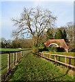
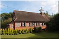
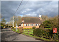
This well on Crazies Hill or Cray-wy-seath Hill or 'the hill of fresh clean water of the waterless place' is scheduled as Historic England List ID 1210646. HE tells us the well house dates from circa 1870 and 'was designed by Gertrude Jekyll, who also painted the gable'.
The well house is described as being: "Roughcast brick. Semi-conical tile roof with gabled front. Semi-circular on plan. Gabled front with semi-circular arch, brick band and dentils above and painting in gable by Jekyll with inscription :-'Rebeka and the Servants of Abraham at the well of Nahor. And the servants ran to meet her and said let I pray thee drink a little water of thy pitcher'.
The Journal of Antiquities also features a page for Rebecca’s Well, Wargrave, Berkshire, adding the well has been frequented for its health-giving, healing properties. The Journal adds the well is located in the woods just a little to the south of Crazies Hill Lane on the way to Cockpole Green.
Note: Have you visited this site? Do you have any photographs or information to add?
You may be viewing yesterday's version of this page. To see the most up to date information please register for a free account.
Do not use the above information on other web sites or publications without permission of the contributor.
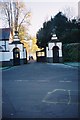
Nearby Images from Geograph Britain and Ireland:
©2016(licence)
©2013(licence)
©2013(licence)
©2005(licence)
©2005(licence)
The above images may not be of the site on this page, they are loaded from Geograph.
Please Submit an Image of this site or go out and take one for us!
Click here to see more info for this site
Nearby sites
Key: Red: member's photo, Blue: 3rd party photo, Yellow: other image, Green: no photo - please go there and take one, Grey: site destroyed
Download sites to:
KML (Google Earth)
GPX (GPS waypoints)
CSV (Garmin/Navman)
CSV (Excel)
To unlock full downloads you need to sign up as a Contributory Member. Otherwise downloads are limited to 50 sites.
Turn off the page maps and other distractions
Nearby sites listing. In the following links * = Image available
2.2km WNW 296° Mont de la Ville* Passage Grave (SU77968140)
4.3km N 11° Medmenham Camp* Hillfort (SU80698467)
4.3km NNE 26° Danesfield Camp* Hillfort (SU81768440)
5.1km E 91° Maidenhead Thicket Bowl Barrow* Round Barrow(s) (SU850805)
5.3km E 84° Robin Hood's Arbour* Ancient Village or Settlement (SU85188108)
5.6km SW 216° Sonning Cursus Cursus (SU767759)
5.6km NE 39° Low Grounds Farm Barrow Cemetery (SU834849)
5.7km SW 218° Sonning Cursus Cursus (SU765759)
6.2km NE 52° Princess Elizabeth's Well* Holy Well or Sacred Spring (SU848844)
9.8km E 80° Bapsey Pond* Holy Well or Sacred Spring (SU896823)
10.3km WSW 239° St. Anne's Well (Caversham)* Holy Well or Sacred Spring (SU712750)
10.3km NNW 328° Stonor Park* Stone Circle (SU74318913)
10.4km NNW 328° Stonor Park Puddingstones Natural Stone / Erratic / Other Natural Feature (SU74288919)
10.8km E 82° Taplow Mound* Artificial Mound (SU90618216)
10.8km SW 215° Whiteknights Stones* Modern Stone Circle etc (SU739715)
10.9km SW 231° Reading Museum* Museum (SU716735)
10.9km ENE 64° Tarry Stone* Marker Stone (SU8974585392)
11.1km E 99° Weir Bank Stud Farm Ancient Village or Settlement (SU90957900)
11.4km WNW 290° Stoke Row Puddingstone* Natural Stone / Erratic / Other Natural Feature (SU6910684123)
11.6km W 273° Castle Grove Camp Hillfort (SU6832580996)
11.6km W 273° Wyfold Castle* Hillfort (SU68328099)
11.6km NW 304° Nettlebed Puddingstones* Natural Stone / Erratic / Other Natural Feature (SU7018186797)
11.9km SE 131° Holyport Modern Stone Circle Modern Stone Circle etc (SU8908672865)
12.0km SE 145° The Quelm Stone* Natural Stone / Erratic / Other Natural Feature (SU870708)
13.5km ENE 68° Root Mound Round Barrow(s) (SU92438574)
View more nearby sites and additional images

