Antarctic sea ice in 2023

Each year, from June-October, polar climate scientists from the Met Office produce a series of monthly sea ice briefings for the government and the general public. These briefings describe the state of Arctic and Antarctic sea ice, compare how these relate to historic patterns, and, where possible, assess causes of unusual behaviour.

Sea ice is frozen seawater that floats on the surface of the ocean and is found when temperatures are cold enough for sea water to freeze. The extent of sea ice is a key climate indicator, because sea ice cover insulates the ocean in winter and reflects sunlight in summer, as well as providing a habitat for a range of species. 

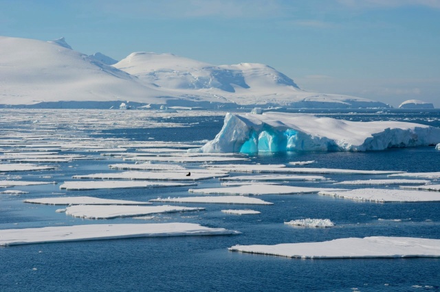
A view of Antarctica showing patches of sea ice, ice bergs and the Antarctic continent's mountains in the distance.

Here, Senior Scientist Alex West talks about the 2023 Antarctic sea ice minimum and its interaction with the ocean and atmosphere.

Lowest sea ice extent on record

Antarctic average sea ice extent for 2023 was the lowest on record. During the ice growth season from June-October, ice extent was exceptionally low for the time of year, reaching over 1 million square km below previous record lows and setting a new record low maximum extent by a very large margin. For much of the rest of the year, the ice was at record or near-record low levels, recording a second successive record low minimum in February (Figure 1).

The annual cycle of Antarctic sea ice build up and loss with individual years highlighted. 2023 was a record low year for Antarctic sea ice extent.

Figure 1. Antarctic sea ice extent in 2023 (bold black line) with other recent years indicated, as well as earlier years with notably low sea ice extent. The 1981-2010 average is also shown, with the shaded region indicating 2 standard deviation intervals.

The very low extent from June-October was partly caused by enhanced warm northerly winds, associated with persistent areas of high and low pressure (Ionita, 2024). Early in the ice growth season, from May-July, these were concentrated near the Antarctic Peninsula, in the Weddell and Bellingshausen Sea regions; later in the growth season, from August-October, the strongest winds were to be found further west, in the Ross Sea. The position of the lowest sea ice conditions changed similarly.

However, it is likely that the ocean also played a part. The low extent of 2023 continues a pattern of very high variability in Antarctic sea ice since 2007, with first high and then low sea ice conditions persisting for long periods of time, in a way unlikely to be caused by known atmospheric changes (Hobbs et al., 2024). A key moment in this period of high variability was a large reduction that occurred in 2016, and this is thought to be linked to changes in the upper ocean caused by stronger westerly winds mixing warmer waters below towards the surface (Earys et al., 2021; Zhang et al., 2022). Further mixing of warm waters cannot be ruled out as an additional cause of the very low extent of 2023.

The precise contribution of anthropogenic (human-caused) global warming to the record low sea ice of 2023 is not yet known. While climate models predict that Antarctic sea ice extent will decrease in response to anthropogenic warming, variability in the past 15 years has been considerable, with very high extent from 2012-2014 followed by the current period of very low extent (Figure 2). Further extreme variability in either direction remains possible in the years ahead.
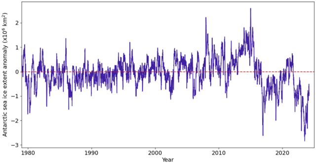
The monthly extent of Antarctic sea ice from 1979 compared with the average from 1981-2010. This view makes it easier to see long-term changes in sea ice.

Figure 2. Antarctic sea ice monthly anomalies over the period of satellite observations. For each month, the 1981-2010 average ice extent for that month is subtracted. This largely removes the seasonal cycle so that subtler long-term changes can be viewed more easily.

During April we are exploring the topic of the ocean and climate. Follow the #GetClimateReady hashtag on X (formerly Twitter) to learn more throughout the month.

References

Eayrs, C., X. Li, M.N. Raphael and D.M. Holland (2021) Rapid decline in Antarctic sea ice in recent years hints at future change. Nat. Geosci., 14, 460–464. https://doi.org/10.1038/s41561-021-00768-3

Hobbs, W., and Coauthors (2024): Observational Evidence for a Regime Shift in Summer Antarctic Sea Ice. J. Climate, 37, 2263–2275, https://doi.org/10.1175/JCLI-D-23-0479.1

Ionita M (2024) Large-scale drivers of the exceptionally low winter Antarctic sea ice extent in 2023. Front. Earth Sci. 12:1333706, https://doi.org/10.3389/feart.2024.1333706

Zhang, L., T.L. Delworth, X. Yang, F. Zeng, F. Lu, Y. Morioka and M. Bushuk (2022) The relative role of the subsurface Southern Ocean in driving negative Antarctic Sea ice extent anomalies in 2016–2021. Commun. Earth Environ., 3, 302. https://doi.org/10.1038/s43247-022-00624-1

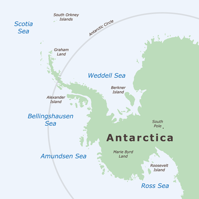
Antarctica map showing Antarctic Peninsula

A map of Antarctica showing the Antarctic Peninsula separated by the Bellingshausen and Weddell Seas. Map: Adobe Stock.

Posted in Met Office News | Leave a comment

NEMO: a numerical ocean model

A numerical ocean model is a computer programme representing the equations of motion (momentum, conservation of mass and thermodynamics) for the ocean. The model stores each of the physical properties of the ocean (temperatures, salinities and currents) on a three-dimensional grid, writes Ana Aguiar.

Ocean models store physical  properties such as salinity, temperature and currents on a three-dimensional grid. Picture: Adobe Stock

Smaller ocean features can be resolved by using a finer grid with more points, but this requires more computational power. The model evolves these physical properties forward in time using its equations of motion. Models of sea ice and biogeochemistry work using similar principles.

Why do we need a numerical ocean model?

We need these models to predict the state of the ocean within short and long timescales for a variety of purposes, ranging from support to operations at sea (for example, search and rescue) to understanding the role of the ocean in the Earth’s climate system. As the ocean sits beneath the atmosphere, sea-surface temperature patterns have widespread impact on the weather over land. Largely because two-thirds of the Earth is covered by ocean and the heat capacity of water considerably outweighs that of the air, the ocean acts as a regulator of the atmosphere.

In polar regions temperatures become cold enough for seawater to freeze and sea ice forms on the surface of the ocean. Sea ice plays an important role in the climate system because it insulates the ocean from the colder atmosphere in winter and, being whiter than the ocean, reflects sunlight in the summer.

The NEMO modelling framework includes a sea-ice model component, known as SI³ (Sea Ice modelling Integrated Initiative). The sea-ice component is run along with the ocean component in a similar manner but using a different set of equations. To understand and prepare for climate change we need to account for the role of the ocean and sea ice.

How is the NEMO model developed?

Nucleus for European Modelling of the Ocean (NEMO) is a state-of-the-art ocean modelling framework. NEMO is developed by a European consortium with the objective of ensuring long-term reliability and sustainability of the code. In other words, the task of maintaining and developing such a complex computer programme requires a well-coordinated team effort, involves tens of developers and hundreds of users.

In the UK there are two member organisations: the Met Office and the National Oceanography Centre (NOC). Met Office Scientific Manager in Ocean Modelling, Ana Aguiar explains: “We work in partnership through the Joint Marine Modelling Programme, contributing to the development of NEMO. The code is publicly available for use in research and commercial applications. It is imperative to reach as many users as possible, to ensure the code gets tested and pushed to the limits of its usability. User requirements then prompt further advances.”

NEMO benefits from continual work to improve its performance (scientific and computational efficiency), to incorporate new scientific and process understanding, and to exploit the increase in supercomputer resources. When the developments are sufficiently mature and can provide significant scientific or technical improvements, a new NEMO version is released. Along with scientific upgrades (which tend to be increasingly computationally demanding), we must deliver code optimisation to make the best use of the available computing resources.
This video presents how NEMO is used by the Copernicus Marine Environment Monitoring Service.

What’s next?

The next NEMO release (expected to be rolled out this summer) will deliver significant improvements to model performance allowing it to run considerably faster. In the long term, among other things, we are also working towards porting the NEMO code to Graphical Processing Units (GPUs) to ensure continuity of the code in future mainstream High Performance Computing architectures

During April we are exploring the topic of the ocean and climate. Follow the #GetClimateReady hashtag on X (formerly Twitter) to learn more throughout the month.


Posted in Met Office News | Tagged , , , , , , , , | Leave a comment

One ocean, one climate 

Our planet is covered in large part by water. Historically, the ocean was referred to as four oceans (Atlantic, Pacific, Indian, Arctic) or five if you included the Southern Ocean (around Antarctica).  

For the ocean science community, it is now accepted there is only one global ocean- and many basins with individual names – says Christine Pequignet, a Met Office senior ocean forecasting scientist.  

There are scientific reasons for this, and important societal consequences. Of course, if you swim off the coast of Hawaii after a lifetime of swimming in the water around Scotland, it will be difficult to recognise that you are in the same ocean. Yet, every ocean basin is connected to at least two others.  

The shape of the ocean basins results from the evolution of one single supercontinent, Pangaea, which was surrounded by one super-ocean called Panthalassa. Like then, the forces that act upon the ocean today know no boundaries, for example the wind, gravity, the earth’s rotation. The resulting circulation of water moves energy, organisms and matter – including pollution – around the globe.  

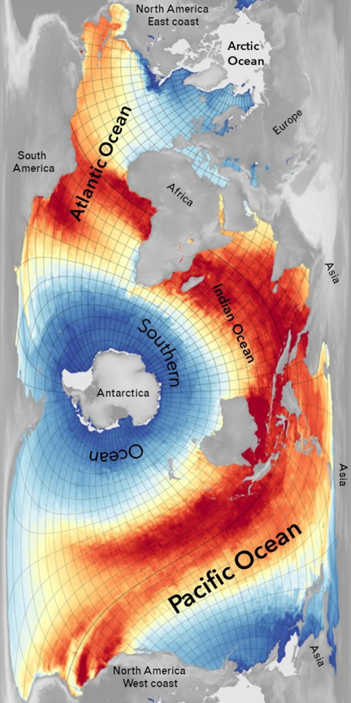
The most common map projections, used to represent the earth on a flat surface, typically focus on land and divide the ocean. However, there are other map projections which instead focus on the ocean, such as the one here to display sea surface temperature, which highlight the inter-connection of the five ocean basins.

A unique and ocean-centric visualisation of the globe surface underlining the one ocean concept.

Map of Sea Surface Temperature plotted on a projection that emphasises the continuous nature of the world ocean (source: Philip Brohan Met Office)

The images we choose, the words we use, all contribute to the perception we have of the world and how we feel about it and how we act.

Talking about a global ocean reinforces the need to approach ocean issues in a universal manner. Knowing that actions on the ocean have both local and global impacts connects us to other communities and reinforces the critical need to protect the marine environment everywhere.  

The ocean is a critical element of the climate system. At a time when the climate is changing at a rapid rate, it is even more important to draw attention to the uniqueness of the ocean and the importance of its role in influencing our planet’s climate. Noone questions the singular use of climate, despite the large range of climates observed around the globe and the variability in impacts that climate change will generate. Climate and ocean processes and issues are global. Along with one climate, there is one ocean.  

During April we will be exploring the topic of the ocean and climate. Follow the #GetClimateReady hashtag on X (formerly Twitter) to learn more throughout the month.

Discover more about the one ocean concept.

Posted in Met Office News | Tagged , , , , , , , , | Leave a comment

Spring starts with a mild and wet March 

Meteorological spring kicked off with a mild and wet month of weather for the UK, with southern areas particularly wet compared to average.  

Although it’s felt like it hasn’t stopped raining for many, no national records have been broken and March 2024 will go down as a wet and dull month, according to provisional statistics from the Met Office.  

Wetter than average 

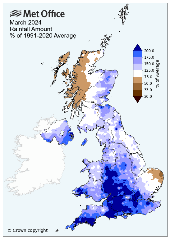
The UK experienced 27% more rainfall than an average March, with much of this concentrated in the south. A number of counties saw at least double the amount of rainfall they would expect for the month, including Cornwall, Dorset, Gloucestershire, Hampshire, Wiltshire and Worcestershire. 

Although Scotland experienced widespread rain throughout the month, it was drier than average, especially in northern and western areas.  

A map of the UK showing average rainfall amounts for March 2024. It shows it was very wet in the south and driest in Scotland.

A mild month 

The month started cooler than average, with some snow falling early on. But this cool weather was soon replaced with milder conditions for much of the rest of the month, with only brief cooler interludes at times.   

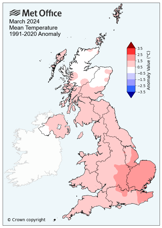
Overall, the provisional mean temperature for the UK was 6.7°C, 1.0°C above average. Southern England was much milder than areas further north, with a mean temperature of 8.2°C (1.4°C above average). Scotland was the coolest region, recording an average temperature of 5.0°C – just 0.6°C above average.  

England provisionally recorded the seventh-warmest March on record in a series from 1884, with an average temperature of 7.8°C.  

Met Office Scientist Emily Carlisle said: “Many will remember how wet March has been, with a succession of fronts and the influence of low pressure seemingly never too far away from the UK. Coming off the back of a wet winter and what has been a wet start to the year, many areas have very saturated ground, which has increased the sensitivity to rainfall events in recent weeks.”  

A map of the UK showing average mean temperatures for March 2024. It shows it was very warm in the South East and the majority of the country, but cooler in Scotland.

Sunshine in short supply 

Many of us have been looking forward to some welcome spring sunshine however, as you’d expect with the frequent rain, sunshine amounts have been in disappointingly short supply during March.  

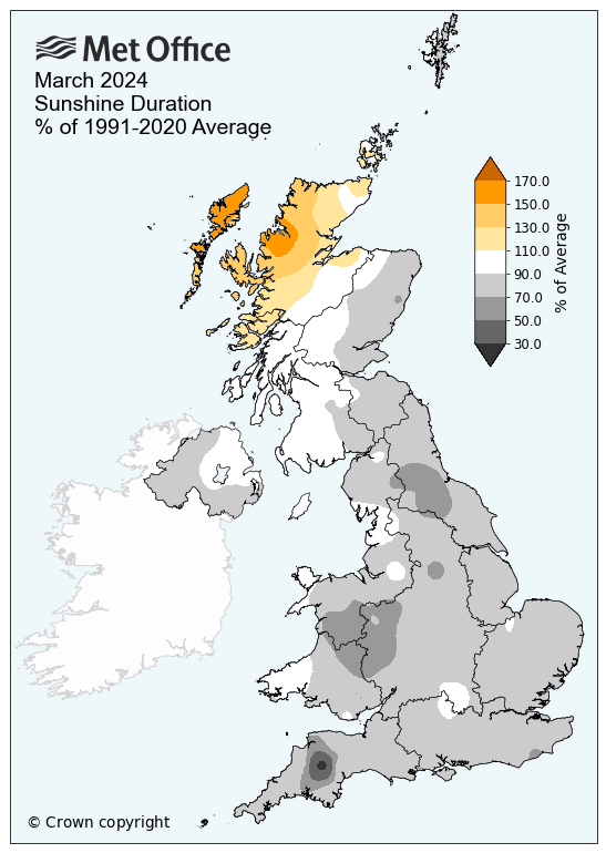
The UK recorded just 95.2 hours of sunshine for the month (87% of the long-term average). Scotland was the only region to have seen more than its average, with 4% extra sunshine hours than the average.  

A map of the UK showing average sunshine hours for March 2024. It shows it was very dull throughout the county, with Northern Scotland seeing the most sunshine.
Provisional March 2024 Mean temp (°C) Sunshine (hours) Rainfall (mm)
Actual  Diff from avg (°C) Actual % of avg Actual % of avg
UK  6.7 1.0   95.2 87  107.8 127
England  7.8 1.4   93.4 80 94.3 162
Wales  7.0 1.1  86.8 79 158.2 153
Scotland  5.0 0.6  101.4 104 112.7 90
N Ireland  6.6 0.6  88.9 88 129.2 149

Posted in Met Office News | Leave a comment

What’s the pollen outlook this year?

The Met Office launches this year’s Pollen Forecast today (Friday 22 March) which will run until mid-September.

One in five people in the UK suffer from hay fever, meaning spring can be the start of watering eyes, runny noses and keeping a keen eye on the pollen forecast, which is now available and provides a look at the pollen amounts and types in the air for the next five days.

This February was the warmest on record for England and Wales and winter too has followed this wet and warm pattern. This has an influence on the pollen season ahead.

Yolanda Clewlow is the Met Office’s Relationships Manager for Health and Air Quality, and the UK Pollen Forecast Manager. She said: “We’re constantly monitoring what’s in the atmosphere and what might be coming in terms of pollen in the air. We look at a very broad picture for the pollen outlook, including the weather in the previous year when pollen is formed on some plants to make a judgement on how heavy a season might be for pollen release. Rain, wind, temperature and sunshine all affect how much pollen will be produced and how much it will be dispersed.”

The Met Office works with the University of Worcester to monitor pollen levels. There are many factors at play when predicting levels, with much depending on how much pollen has formed on the plants and the weather at the time of release. Most people are allergic to grass pollen, which is generally released around mid-May to July.

Yolanda continued: “In terms of birch pollen, we are seeing the first grains in the atmosphere in the most southerly and easterly counties but overall, there’s currently generally low levels for tree pollen due to changeable conditions. We expect the season to be of mild to average severity depending on in-season weather.

“Grass pollen could start early, with some pollen airborne from late April. Average severity is most likely, but this will largely depend on the weather in April and early May. Warm sunshine and some rain is needed for good grass growth and pollen production. Dry conditions would inhibit growth.”

There are millions of hay fever sufferers across the UK. The Met Office pollen forecasts provide vital information to help reduce the impact pollen has on their health. 

Emma Rubach is the Head of Health Advice at Asthma + Lung UK. She said: “High pollen levels can be dangerous for people with lung conditions like asthma or COPD (chronic obstructive pulmonary disease), triggering symptoms such as breathlessness, coughing or wheezing. and could lead to hospitalisation or a potentially life-threatening asthma attack.

“To protect themselves, we would advise people with hay fever to use their preventer inhaler every day as prescribed, if they have one, and always have their reliever inhaler with them, in case symptoms do arise.  

“If you’re allergic to pollen, using steroid nasal spray every day can also help, together with non-drowsy antihistamine tablets to help reduce the allergic reaction. It is also a good idea to check pollen and air pollution forecasts in their local area, so they can avoid going outdoors as much as possible on high pollen days.”    

The three types of pollen

The pollen season generally has three main pollen type phases:

  • Tree pollen – late March to mid-May
  • Grass pollen – mid-May to July (most people are allergic to grass pollen)
  • Weed pollen – end of June to September

“The first thing to do is to make sure you understand the type of pollen you’re allergic to and monitor the forecast,” said Yolanda.  

“That way, you know when the very high days of pollen are coming and you can take precautions to try and avoid the pollen. It’s not possible to avoid it altogether though so for some, it’s about taking that preventative medication and planning your day to try and avoid being out in the pollen at the peak times.”

Pets can also be affected by hay fever and in severe cases, vets can often prescribe medication to help furry friends through the summer.

Advice on dealing with hay fever is available as part of WeatherReady with the Met Office.

Pollen levels and climate change

With global temperatures increasing, the pollen season in the UK isn’t immune to the effects of a changing climate. Climate models suggest an increasing likelihood of warmer, wetter winters and hotter drier summers, which will influence the release of pollen into the atmosphere.

A study conducted by the University of Worcester looked at pollen trends in the UK over the last 26 years to better understand the relationship between these trends and meteorological factors. It examined a range of UK pollen sites, with a focus on the key pollen types: grass, birch and oak. 

Dr Beverley Adams-Groom, Senior Pollen Forecaster at the University of Worcester and lead author of the study, said: “Birch tree pollen is showing a trend for increasing severity, particularly in the Midlands region, but grass pollen is not showing an increase over time. Seasons for all pollen types are tending to start earlier and earlier but there is no evidence that season duration is changing. Where changes are occurring, these are largely related to the effects of global warming, with similar patterns seen from research in nearby countries.”

Get pollen alerts directly to your phone on the Met Office app, or visit the pollen forecast on the Met Office website.


Posted in Met Office News | Comments Off on What’s the pollen outlook this year?

Met Office scientists protecting our forests from pests and pathogens

Today is the United Nations International Day of Forests, and in this blog post we explore the importance of this work.

The Climate and Plant Biosecurity Climate Service, funded by the Department for Environment, Food and Rural Affairs (Defra), is a collaboration between the Met Office’s Vegetation-Climate Interactions team, Defra’s Plant Health Risk and Horizon Scanning team, the University of Exeter, Fera Science, the University of Warwick, Forest Research and The Royal Botanic Gardens, Kew.

Oak processionary moth caterpillars. This species is a non-native pest of woodlands. Picture: Adobe Stock.

Since 2006 the non-native and invasive Oak Processionary Moth has been spreading across England and Wales. Picture: Adobe Stock

The aim of the service is to provide analyses, tools and guidance to help manage the climate-related risks to UK plants, particularly trees and forests, from plant pests and pathogens.

Pest and pathogen outbreaks

Pests and pathogens present serious risks to our trees and forest habitats as well as the ecosystem services they provide. The number of new pest and pathogen outbreaks affecting trees has increased rapidly in recent years (see table, Source: Forestry Commission).

Year (since 1971)             New tree pest or pathogen outbreak

  • 1971      Dutch elm disease
  • 1983      Great spruce bark beetle
  • 1984      Phytophthora alni
  • 1995      Gypsy moth
  • 1997      Dothistroma needle blight
  • 2002      Phytophthora ramorum
  • 2002      Horse chestnut leaf miner
  • 2003      Phytophthora kernoviae
  • 2005      Bleeding canker of horse chestnut
  • 2006      Oak processionary moth
  • 2006      Phytophthora pseudosyringae
  • 2007      Pine tree lappet moth
  • 2010      Acute oak decline
  • 2010      Phytophthora lateralis
  • 2012      Ash dieback
  • 2012      Asian longhorn beetle
  • 2012      Sweet chestnut blight
  • 2012      Phytophthora austrocedri
  • 2014      Phytophthora sikiyouensis
  • 2014      Sirococcus tsugae
  • 2015      Oriental chestnut gall wasp
  • 2017      Elm zigzag sawfly
  • 2018      Eight toothed spruce bark beetle
  • 2021      Phytophthora pluvialis

Climate (variability and change) influences pests and pathogens in many ways, including i) the timing of life cycle events (such as emergence from egg to caterpillar), ii) the spatial distribution and spread, and iii) the introduction and establishment of non-native species.

Tools to help manage UK plant biosecurity

The UK Climate-Pest Risk Web Tool is one of the tools that has been developed by Met Office scientists Neil Kaye and Deborah Hemming (Vegetation-Climate Interactions team) in collaboration with biosecurity and forestry experts at Defra, Forest Research, Fera Science and the University of Warwick. It integrates ecological knowledge and models of known temperature thresholds for different pests/pathogens, with up-to-date climate observation datasets from the Met Office National Climate Information Centre.

Deborah Hemming, Scientific Manager of the Vegetation-Climate Interactions team at the Met Office, who leads this climate service, notes: “When tree pests and diseases become established, they can wreak havoc on our woodlands. Commercial forestry can be affected hugely, but they also affect the landscapes of our islands which many people love and cherish. In the 1970s, Dutch Elm Disease killed most of the UK’s stately elm trees with those plants remaining being small stands in isolated sections of hedgerow. Similarly, Ash Dieback since 2012 has decimated ash trees with similar devastating effect.

“When trees die, especially native broadleaf trees, there are impacts on landscape and wildlife. And in times of climate change there is also a reduction in the availability of carbon stocks because trees provide a hugely valuable ecosystem service by drawing down atmospheric carbon and locking it away. By joining forces with experts in plant biosecurity at Defra, ecological modelling at University of Exeter, forestry at Forest Research and ecological systems at Royal Botanic Gardens, Kew, we are able to provide scientifically robust and useful research, tools and services to help protect UK trees and forests now and into the future.”

The tool enables users to easily estimate the timings and locations of pest outbreaks across the UK, and inform actions to assess, survey, monitor and eradicate plant pests, helping to enhance UK plant biosecurity.

Simon Toomer, Curator of Living Collections at Royal Botanic Gardens, Kew, says: “As we develop strategies and plans to adapt and prepare our tree and shrub collections for changing climatic conditions, one of the most complex and least understood threats is that from pests and diseases. This research is going to help us understand how changes in general climate variables translate into changes in the specific conditions experienced by pest species, and how we may adapt our management accordingly.”

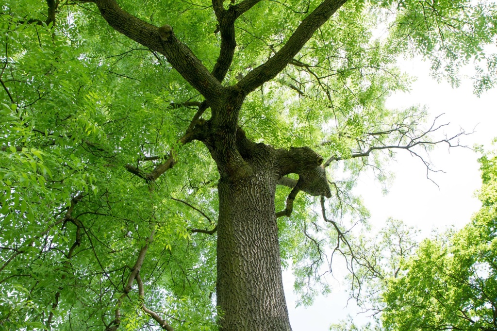
Healthy ash trees form an important part of the UK's tree canopy. Isolated trees are also a feature of hedgerows. Picture: Adobe Stock

Healthy ash trees form an important part of the UK’s tree canopy. Isolated trees are also a feature of hedgerows. Picture: Adobe Stock

Improving monitoring and modelling of microclimates

Pests and pathogens respond to microclimates within the habitats where they live. To improve the estimates of pest/pathogen risks, ecological modellers at the University of Exeter have developed mechanistic microclimate models to estimate temperature and humidity within relevant habitat locations e.g., under tree canopies, inside tree trunks or buried at various depths within the soil. In these habitats, microclimates can vary by 40-50°C and be significantly different to conditions observed at weather stations.

Ilya Maclean, Professor of Global Change Biology at the University of Exeter, says: “It is important to understand the climate as pests and pathogens experience it. This can be very different from the conditions measured by a weather station. My team is developing models that allow us to do this and the data we are collecting as part of this project will be invaluable in helping us improve our models”.

Daegan Inward, Senior Scientist at Forest Research, explains further: “We know that beetle outbreaks are often associated with sun-warmed stems, and understanding the under-bark microclimate is important to help predict the risk of insect establishment and population growth in Britain.”

Climate change and globalisation

To validate the microclimate models, in February 2024 the Met Office, the University of Exeter, Forest Research and Kew Gardens began a campaign of microclimate monitoring at five sites in different forest habitats across southern England (Cornwall, Dartmoor, Alice Holt, Kew Gardens and Wakehurst). The team installed a series of sensors to monitor temperature within the woodlands and inside tree trunks. The data collected will help improve the understanding and modelling of variations in the pest/pathogen microclimates, and therefore the estimates of biosecurity risks.

Defra Chief Plant Health Officer Nicola Spence said: “Climate change and globalisation are increasing the number and diversity of pests and pathogens we are exposed to, resulting in an ever-growing number of threats. This collaborative effort to develop climate modelling tools and improve our understanding of pest or pathogen climate interactions, will allow us to better plan for and improve our ongoing surveillance and monitoring. This work is crucial to adapt to a changing climate and better understand how the health and resilience of our trees could be at risk.”

Posted in Met Office News | Tagged , , , , , , , , , , , | Leave a comment

One in 250-year event underway high in the atmosphere.

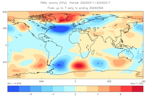
For the first time since records began in the mid 20th century , this extended winter period (November to March) is the first in our observational records to see three Sudden Stratospheric Warming (SSW) events. Met Office research suggests the likelihood of having three SSW events in one winter period is just a one in 250-year chance, although it is more likely to happen during an El Niño winter, such as this winter.

The record of SSW events goes back to the 1950s with the introduction of radiosonde balloons which are used to take observations high in the stratosphere on a routine basis. Since then, there has been typically one SSW every two extended winters. However, there are occasional runs of years with no warming events at all e.g. in the 1990s. There are also winters with two warmings such as the winter of 2009/10.

Professor Adam Scaife, Head of Long-Range Forecasting at the Met Office, said: “Although we have not seen it before, we recently documented the chances of an unprecedented three SSW events happening in one winter. Our research work, using multiple computer simulations, showed that this could occur about once in every 250 winters.”

Professor Scaife added, “Although this is very rare, we also found that the chance of multiple SSW events is increased during El Niño and so the chance of multiple events this winter is raised.”

3rd SSW winter

Forecast pressure for mid-March showing relatively high pressure over Iceland and low pressure over mid latitudes (Units: hPa).

A SSW is a disruption of the normal westerly air flow 10 to 50 km above the earth. This often makes the jet stream meander more, which can lead to the development of a large area of high pressure over northern Europe at the Earth’s surface. This can ‘block’ the Atlantic low-pressure systems which are responsible for the relatively mild, wet and windy weather that often occurs in UK winters. This blocking pattern increases the chance of cold, dry weather in the UK and mild, wet and windy conditions for southern Europe. However, the impacts of an SSW do not always equate to cold weather, for example, we have only seen intermittent drops in temperature around the two SSW events early this winter and typically around 70% of events are associated with a cold snap.

SSW is just one of a number of global drivers that can affect weather in the UK, the current SSW is consistent with the latest long-range outlook for March which suggests a continued increased chance of blocked, high-pressure conditions to the north of the UK and a southward shift in the Atlantic jet stream.

Posted in Met Office News | Tagged , , , , | Leave a comment

Wildlife banking on a warm spring

Today (1 March 2024) is the first day of meteorological spring. We cannot yet guarantee exactly what this spring will bring, but wildlife will be betting on another warm one, writes Grahame Madge – a Met Office climate spokesman and wildlife enthusiast – ahead of the United Nations’ World Wildlife Day on Sunday.

The red admiral butterfly can now be seen on virtually any warmish day in the UK. Previously it wasn’t an over-wintering species and it only used to occur here in the warmer months as a visitor from further south. Picture: Grahame Madge


For the UK, the five warmest springs since 1884 have all occurred since 2007. Wildlife is responding to this shift towards warmer springs by accelerating their own activities.

An index of spring – compiled from observations of the appearance of key spring wildlife species – is occurring many days earlier now when compared with the first half of last century.

The wildlife spring index shows the timing of biological spring events (the number of days after 31 December) in the UK. From 1891 to 1947 the Royal Meteorological Society provided the data, while from 1998 to 2022 it was provided by the UK Phenology Network (Nature’s Calendar, currently funded by the People’s Postcode Lottery, Postcode Green Trust). The Spring Index is calculated from the annual mean observation date of the following four biological events: first flowering of hawthorn; first flowering of horse chestnut; first recorded flight of an orange-tip butterfly; and first sighting of a swallow.


Already this year, at least one swallow has been reported in southern England; returning from Africa well ahead of the rest of its cohort. I have seen red admiral butterflies, bumble-bees and many chiffchaffs – a small usually summer-visiting songbird – in my corner of Exeter and sections of my walk to work have been lined with primroses. Anecdotally, these sightings are much earlier than I would expect.

However, my ad-hoc sightings in the margins of my dog-eared notebook are backed up by an army of wildlife fans diligently recording species across the UK through the Woodland Trust’s Nature’s Calendar scheme.

The recording of the timing of biological events is known as phenology. Two long-running nature surveys – monitoring four easily recorded species – have revealed that the average of time of appearance of these four species since 1998 is 8.7 days earlier than the average dates in the first part of the 20th Century. This is alarming, but not exceptional as other trends have been recorded too.

The dashed trend line in this graph shows that the UK spring has become more than 1.0°C warmer in the last 100 years.

A new course for the red admiral

The striking red admiral butterfly has always been a familiar visitor to parks and gardens the length and breadth of the UK. It used to be an exclusively migratory butterfly arriving on our shores after crossing the English Channel. But warmer winters are now altering this insect’s behaviour. Our winters are now becoming warm enough for it to overwinter as an adult to emerge on warm days in winter or early spring.

The warming of our climate is leading to a response from nature. The red admiral is an extremely abundant and seemingly adaptable insect, so it is unlikely to suffer any population consequences from this behaviour; at least at a species level. However, you have to wonder about the fate of those individuals encouraged to take their first flight of the year in winter, only to be hit by frost a few days later. What happens to them?  My colleague Dr Mark McCarthy a Met Office climate statistics expert noted: “While frosts and cold spells in winter are falling, the date of first/last frost haven’t actually shifted all that much. So, although there are fewer frosts overall the risk of a ‘false spring’ in winter can increase the exposure to spring frosts later in the season. So, for parts of the environment and the agricultural and horticultural sectors there can be increased frost risks even with a declining trend.”

What happens when nature can’t rely on a warm spring?

Many species are making the most of warmer winters and springs to gain an ecological advantage and make the most of the changing seasons. In fact, they are banking on the UK’s climate statistics showing that winter and spring are becoming warmer, on average. But these trends are derived from seasonal averages of temperatures observed over a standard three-decade period. Occasionally, the actual temperature can be a long way from the long-term average and wildlife can be caught out by a colder-than-average spring. This happened in 2013.

The spring of 2013 was the coldest in the UK in 50 years. Some species were severely impacted. Although not a common event, springs as cold as 2013 happened more frequently in the late 19th and early to mid 20th Century.

The stone-curlew is one of England’s rarest birds, with a small and vulnerable population in southern and eastern England. Picture: Adobe Stock


In 2013 I worked for the RSPB, and we were being besieged by members of the public reporting odd birds turning up in gardens desperate for food and respite from the cold. The greatest concerns for a conservation organisation were the fates of those species whose populations had become severely depleted by other factors. The number one species of worry was for the stone-curlew, a species of wading bird thinly spread across parts of the agricultural landscapes of southern and eastern England. The birds spend the winter around the Mediterranean and arrive back on their nesting sites in early spring. Farmers were reporting numbers of these birds which had succumbed to the cold because of a lack of food. At the time the RSPB’s conservation director Martin Harper said: “I can’t remember a spring like this – nature has really been tested by a prolonged period of very cold weather.”

During parts of March 2013, the average temperature in the UK dipped to their lowest levels.


Climate change is affecting many species of wildlife. Some will adapt and others won’t. But even those with potential to adapt may be confounded by other factors, and populations which are already depleted will be less resilient to climate change impacts.

Posted in Met Office News | Tagged , , , , , , , , , | Leave a comment

The risk of wildfires in a changing climate 

Fires can be a natural and positive part of the healthy functioning of many ecosystems. However, the pattern of large or unusual fires – known as wildfires – is changing, and there is scientific consensus that climate change is promoting the conditions on which they depend, such as the frequency and intensity of fire weather.  

Fires mostly result from the interaction between climate conditions (such as temperature, moisture, and lightning), vegetation (fuel availability and dryness) and people (through land-use change, ignition, and suppression), and changes in these factors are leading to shifts in fire patterns in many regions of the world.  

It is widely known that the overall global burned area is decreasing, as explored by one report from Science magazine in 2017. This is mainly driven by land-use change from natural savannah and grasslands to agriculture. However, changes in land use can act as a driver for fires in different areas such as tropical forests, and in other regions such as high-latitude forests wildfires are increasing more in line with fire weather and fire season length. Extreme weather, a warming climate, and a build-up of dried-out vegetation acting as fuel, can also result in fires that are larger, more intense, or more frequent than normal, which can lead to the destruction of habitats (wildlife and vegetation) and negative impacts on society (destruction of infrastructure, displacement of people, and air pollution), as well as impacting carbon sinks. 

A negative cycle 

Wildfires and climate change can be part of a negative cycle. Fires can contribute to climate change through releasing carbon from soils and vegetation but are also affected by climate change through hotter and, in places, drier conditions.  

Climate change can lead to plant life drying out more quicky, which creates more flammable vegetation to burn. In turn, this burning contributes to climate change by the release of carbon and the destruction of natural carbon sinks, such as forests. The effects of climate change on wildfires have been apparent in many regions of the world in recent years. For example, climate change more than doubled the likelihood of extreme fire weather in Eastern Canada in 2023 (WWA), and extreme wildfires are moving into unexpected places – like the Arctic, wetlands, peatlands and rainforests that would not previously have been expected to burn easily (UNEP 2022). The vegetation in these are places is not adapted to fire and these locations also hold huge amounts of carbon. Fire’s overall contribution to the carbon cycle though is complex, including carbon uptake in plant regrowth, phytoplankton blooms in the ocean, storage of burnt carbon in soils, as well as variable effects from aerosols.  

It is important to note that climate change will not impact all environments in the same way. In some areas climate change may lead to changes in precipitation and fuel availability, which may decrease flammability, but in other areas climate change may increase fires (e.g., extreme fires in Europe). Higher temperatures alone will not necessarily lead to more fires in all cases; however, our climate system is finely balanced, and small changes can have significant consequences. At 2 °C of warming, models calculate that more areas globally would be at risk of higher fire danger compared to today. Overall, the changing and warming of the climate has increased the scale, intensity, and impact of extreme events in many regions across the globe. 

Met Office research 

The Climate Science for Service Partnership Brazil (CSSP Brazil) research project aims to build strong partnerships between research institutes in the UK and Brazil. As part of this project, scientists from the UK and South America have worked together to develop a seasonal fire probability forecasting service. This delivers forecasts of fire probability for South America several months in advance and enables communities to prepare for these events and mitigate some of the risks posed.  

Dr Chantelle Burton, climate scientist at the Met Office, said: “We are already seeing the impact of climate change on weather patterns all over the world, and this is disrupting normal fire regimes in many regions. It is important for fire research to explore what is changing, what effect this could have on people and the environment, and what communities need to do to prepare.” 

Follow the #GetClimateReady hashtag on X (formerly Twitter) to learn more about forests and climate change. 

Posted in Met Office News | Tagged , , , , , , , | Leave a comment

A precautionary approach required to avoid large-scale collapse of the Amazon forest

The Amazon is a complex dynamical system with extraordinarily diverse terrestrial and aquatic ecosystems which are home to more than 10% of Earth’s biodiversity, as well as 40 million people.

It is one of the most critical elements of the Earth’s climate system, with the forest acting as a giant “air-conditioner”, lowering land-surface temperatures and generating rainfall in the region. as well as exerting a strong influence on the atmosphere and circulation patterns, both regionally and globally. It also acts as an important terrestrial carbon sink, absorbing more carbon from the atmosphere than it releases and storing an amount of carbon equivalent to 15-20 years of global CO2 emissions (150-200 Pg C), helping to limit atmospheric concentrations and accelerated global warming.

Pied tamarin
The pied tamarin is one of the world’s most threatened primates. Confined to a small part of the Brazilian Amazon rainforest, the Critically Endangered monkey is affected by several factors, largely linked to deforestation. Picture: Shutterstock

Large parts of the Amazon forest, however, are projected to die within this century due to climate and land-use changes, which could trigger cascading effects and push Earth’s climate to a substantially warmer and unpredictable state. It remains uncertain whether a large-scale dieback of the Amazon could actually happen within the 21st Century though the possibility has raised significant global concern.

A new study led by Dr Bernardo Flores of the Federal University of Santa Catarina and including a team of collaborators from Brazil, Europe and the USA, Critical transitions in the Amazon forest system, has synthesised existing evidence for five potential critical thresholds in the Amazon forest. In the context of climate science, a critical threshold refers to potential tipping points in the earth’s system or related processes which, if passed, can cause sudden, dramatic or even irreversible changes to some of the earth’s largest systems, such as the Antarctic ice sheet or the Amazon rainforest. The resulting socio-economic impacts could be very large, and crossing of one critical threshold may then make others more likely to be crossed. Understanding the impact of tipping points is an important element of climate change risk assessment.

Tipping point potential

Partly funded by the Climate Science for Service Partnership (CSSP) Brazil and AmazonFACE, the study has assessed the existing evidence combined with the most plausible ecosystem trajectories and spatial climatic variability, identifying areas within the Amazon forest with higher tipping point potential by the year 2050. AmazonFACE conducts crucial work on the existence, magnitude and duration of CO2 fertilization in the Amazon, which the new study highlights as a key uncertainty in the Amazon crossing a critical threshold.

Flores said: “Findings show that the forest is becoming increasingly exposed to warming temperatures, droughts, deforestation and fires, even in the west of the region that was previously remote to these pressures.”

Mechanisms that previously maintained the Amazonian forest’s resilience to large-scale tipping points are now weakening, increasing its vulnerability to change. Intensification of climatic variability and disturbance regimes in the region over the coming decades may expose an additional 10 – 47 % of the Amazon forest biome to tipping events. In such scenario, the system could cross the tipping point in accumulated forest loss, triggering a large-scale dieback of the Amazon, and being replaced by either degraded forest, savanna or degraded open-canopy ecosystems. This would result in the region becoming a major source of greenhouse gases rather than a carbon sink, risking efforts to keep global warming below 1.5oC.

Flores continues: “Compounding disturbances are increasingly common within the core of the Amazon. If these disturbances act in synergy, we may observe unexpected ecosystem transitions in areas previously considered as resilient, such as the moist forests of the western and central Amazon.”

Opportunities

However, the study reveals opportunities for action to help reduce the pressures on this iconic system and the essential ecosystem services it provides. Findings suggest a list of thresholds that, if well managed, can help maintain the Amazon forest within a safe operating space, avoiding a catastrophic dieback. These depend on ending forest loss and boosting forest restoration at the local scale, but also on global efforts to reduce greenhouse-gas emissions. The consequences of losing the Amazon forest, or even parts of it, imply that we must follow a precautionary approach.

Co-author Professor Richard Betts MBE, of the Met Office, comments: “After 25 years of research, the potential for a tipping point in the Amazon has gone from a theoretical concept to a real and imminent threat. We still have the chance to avoid it by both stopping deforestation and halting global warming by phasing out fossil fuels, but both of these need to happen urgently.”

Article: Flores et al. (2024) “Critical transitions in the Amazon forest system”, Nature, DOI:10.1038/S41586-023-06970-0.

Posted in Met Office News | Tagged , , , , , , , , | Leave a comment