Grid reference NN165711
4 km NE of Achriabhach, Highland, Scotland
Coverage
We have 185 images in grid square NN1671
Contribute
Explore centiquare NN165711
Explore gridsquare NN1671
Surrounding area
Maps
 Map © Crown Copyright")
TIP: Click the map for more Large scale mapping
Tip: Click the map to open the coverage map
A sample of 12 photos from 185 for NN1671 - View this square in the Browser >>>
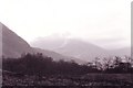 |
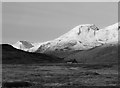
Ben Nevis
by martin more
Ben Nevis seen at around 4am from a camp near Achriabhach. Looking east-north-east. Taken Easter 2000 during an expedition.
|
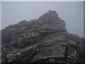 |
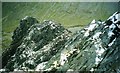
Cairn on the Great Tower
by Callum Black
A misty, wet day on Tower Ridge. This cairn is at the top of the Great Tower, close to the top of the ridge. All that lies between here and the summit of Ben Nevis is the Tower Gap (and a little more climbing...)
|
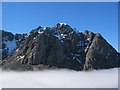 |
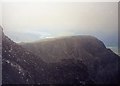
Ben Nevis - North Face above Cloud Inversion
Taken from the slopes below Carn Beag Dearg at 11:39 on 5th April, 2003.
|
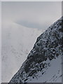 |
Observatory Buttress
From the base of Indicator Wall. Carn Mor Dearg beyond.
|
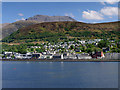 |
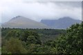
Fort William, Cow Hill and Ben Nevis
by David Dixon
Although Fort William is often described as a "Gateway to Ben Nevis", the summit cannot be seen from the town because the view is blocked by Cow Hill. To get a view of Ben Nevis from this direction, you have to go onto Loch Linnhe.
|
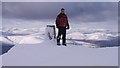 |
Ben Nevis trig
by Jonathan A
9th April 2006 the day after my 30th birthday! I set up a Amateur radio station up on the summit just off camera near the old Observatory part of SOTA (summit on the air). The Temperature was -6.
|
 |
Ben Nevis and Carn Dearg
Cliff at the summit of Ben Nevis, with Carn Dearg beyond. In the far distance Loch Eil and the pulp and paper mill at Corpach.
|
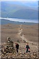 |
The Tourist Path up The Ben
by Mick Garratt
|
 |
Ben Nevis from the East
by Richard Webb
View from frozen bogs near Meanach with the North East Buttress clearly visible on the right. Note the curious circular rock formation on the north side of Glen Nevis.
|
 |
Ben Nevis from the Caledonian Canal
by Jim Barton
The Ben, brooding in cloud and still harbouring a snow patch in one of the N face gullies, seen from the canal towpath approaching Loy.
|
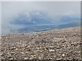 |
And the cloud lifted ...
by Mike Quinn
... but only for a few seconds - revealing Loch Lochy, some 10 miles to the north.
|
 |
Tower Ridge and the Douglas Boulder
by Iain Lees
|
Explore more images in this square: | View Filtering options | View all 185 images page by page >>> |
|