Grid reference SO050067
near to Merthyr Tydfil/Merthyr Tudful, Wales
Coverage
We have 61 images in grid square SO0506
Contribute
Explore centiquare SO050067
Explore gridsquare SO0506
Surrounding area
Maps
 Map © Crown Copyright")
TIP: Click the map for more Large scale mapping
Tip: Click the map to open the coverage map
Sample images Breakdown list taken pre 2000 [1]
A sample of 12 photos from 61 for SO0506 - View this square in the Browser >>>
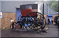 |
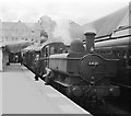
Trevithick Industrial Estate, Merthyr Tydfil
by Chris Allen
On the occasion of the 200th anniversary of Trevithick's Pen-y-Darren locomotive. The photograph includes the replica of trevithick's 1803 London steam carriage. Not sure I would fancy sitting so high up and with one of... (more)
|
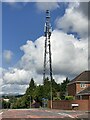 |
Communications mast
by Alan Hughes
|
 |
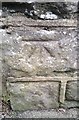
Ordnance Survey Cut Mark
by Adrian Dust
This OS cut mark can be found on the wall north side of Penyard Road. It marks a point 219.176m above mean sea level.
|
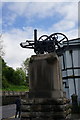 |
Monument to Richard Trevithick (set of 2 images)
by Ian S
Merthyr Tydfil.
|
 |
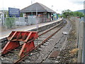
Merthyr Tydfil railway station
by Flying Stag
This is the 1405 Saturday only branch train to Hirwaun, where a connection will be made with a train to Neath. The original station shown here was demolished in the 1970s and the current station lies to the south west.
|
 |
Merthyr Tydfil railway station, Mid Glamorgan
Opened in 1996 by British Rail at the end of its line from Cardiff via Pontypridd, the line stopped 200m short of the original 1853 Vale of Neath (later Great Western Railway) station which covered most of this site. The GWR 1853 terminus... (more)
|
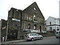 |
The Miners Arms
A town centre pub situated in the basement of a ruined church, on Church Street, Merthyr Tydfil.
|
 |
Concrete spheres in Beacons Place, Merthyr Tydfil
by Jaggery
Near Merthyr Tydfil railway station and Tesco Extra. Link
|
 |
Monument to Richard Trevithick
by RAY JONES
Replica steam engine
|
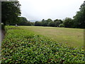 |
Thomastown Park Recreation Ground
by Eirian Evans
|
 |
St Tydfil's Hospital, Merthyr Tydfil
by John Lord
|
 |
Ordnance Survey Cut Mark
by Adrian Dust
This OS cut mark can be found on the wall post of Bryn Heulog, Bryntirion Road. It marks a point 192.673m above mean sea level.
|
Explore more images in this square: | View Filtering options | View all 61 images page by page >>> |
|