|
|
|
Historical Seismicity of Montenegro |
|
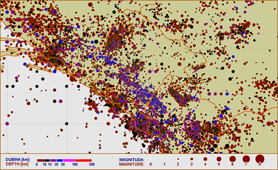
During XX century, seismic activity at the Montenegro territory and its surroundings was characterized by intense seismicity. Several thousand strong and very strong earthquakes occurred in this region during that period. Some of them were recognized as destructive and catastrophic ones. The numerous old archives describe broader Balkan region and Montenegro coastal area as a territory with high level of seismic risk. Epicentral map lead us to conclusion that Montenegro coastal area is characterized with much higher seismic hazard than inland part, not only of Montenegro, but also of the broader region. It is very important to emphasized seismic zones of Ulcinj, Budva, Gulf of Kotor and Skadar Lake that generated very strong earthquakes in near or distant past (13th June 1563 - Gulf of Kotor, 25th July 1608 - Gulf of Kotor, 15th April 1979 - Adriatic Sea, 24th May 1979 - Adriatic Sea).
Deep seismoactive structures can be recognized on map, e.g. large tectonic trench which is placed in the Dinarides direction, from northern Albania, via Podgorica, Danilovgrad, Bratogost at the western part of Montenegro, and further to the west of the Bosnia and Herzegovina. On the epicentral map this tectonic trench can be noticed by position of relatively deep hypocenters (blue circles).
|
 |
|
|
|
|
|
Earthquake activity for the Montenegro territory and its surroundings from 1901 to 2010
|
|
|
|
The earthquake of 15th April 1979 at 07:19 AM (local time) had Richter magnitude of 7.0 and caused catastrophic destruction. The whole Montenegrin coastal area during this earthquake was shocked by the intensity of IX degree Mercaly scale. Epicenter of earthquake was located in the Adriatic Sea, between Ulcinj and Bar, on distance 15 km from the coast. This earthquake took 101 lives in the Montenegro and 35 in Albania. Several towns were destroyed, namely Ulcinj, Bar, Petrovac, Budva, Tivat, Kotor, Risan and Herceg Novi, as well as 250 villages. By the end of 1979, 90 strong earthquakes were recorded with Richter magnitude 4.0 or bigger, over 100 earthquakes with Richter magnitude 3.5 - 4.0 and almost 10.000 weak shakes.
Southwest of Montenegro was destroyed many times from XV to XVII century. Also, in the 1905 the southeast part was stroked by Skadar earthquake (north Albania). On the epicentral map we can notice pretty large seismic induced activity in the region of the artificial lake created by the dam “Piva” which is 220 meters high and situated in the northwestern part of the Montenegro. The main part of the seismic activity in this region is related to the oscillation of hydrostatic pressure of the reservoir water at the limestone masses in the basement, during the charging and discharging of the lake. Number of registered earthquakes varies in very wide limits. During calm seismic year, Montenegro seismological observatory registers about 400 earthquakes, with Richter magnitude 1.2 or bigger. During seismic active years, that number can increase to over 30.000 earthquakes with Richter magnitude 1.0 or bigger.
|
|
|
|
|
|
|