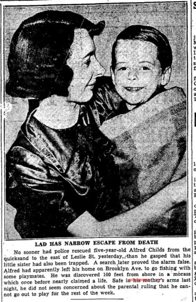
Children play with human bones, Toronto Star, May 6, 1959
Children play with human bones, Toronto Star, May 6, 1959
Children play with human bones, Toronto Star, May 6, 1959
Children play with human bones, Toronto Star, May 6, 1959
A long time ago, before most of us knew anything about pandemics, social isolation (quarantine) and social distancing, Toronto knew epidemic disease too well. Travellers bought it here: some were sick when they arrived, others appeared healthy but were already infected. But these weren’t tourists or people returning home after a business trip or a holiday oversea. These were what some term “economic refugees”. They were Irish fleeing the Potato Famine, hoping to find food and a home, desperate, some already beginning to starve. There was no Canadian Border Agency to stop them. They had no visas, they just came.
The Instigator
On August 20, 1845, the curator of Dublin’s Botanic Gardens. David Moore, discovered the potato blight Phytophthora. The wind or a careless botanist carried the spores of this American mould (an oocyte, not a fungus) across the Atlantic to Europe. Since potatoes spread vegetatively, the Irish potatoes were genetically alike: clones. Several varieties of potato were grown in Ireland, and the very worst of them — lumpers — were what the peasants ate. With no genetic diversity, the lumper variety that the Irish ate had no resistance to the unknown pathogen. Potato blight withered the foliage in the field, turned the spuds in the ground into a gooey, stinking inedible mass and even rotted the tubers in storage.
The potato was the staple food for poor people across Western Europe by this time. But the Irish poor were particularly reliant on it. Potatoes provide everything except calcium and vitamins A and D, which are readily available from milk, and many Irish families kept a cow and, if a little more prosperous, a pig. A simple diet of potatoes and milk did provide a healthy diet for people with little access to other foods, such as fresh fruits and vegetables.
Potatoes are easy to grow. A large crop can be grown on a tiny plot of land. Few tools are required, just a spade and a pot and a peat fire to cook your spuds on. Potatoes produced more food per acre than any other crop Irish farmers had grown before. They produced more calories per acre. Rye was the only grain that could be depended on to ripen in the short, rainy summers of Northern Europe that extended from the North Sea to the Ural Mountains. Four times as many people could live on potatoes from the same amount of soil that produced rye. Potatoes could be planted in the fallow fields required for the cultivation of rye. One acre could feed eight people. A working man could live on three kilos of potatoes a day, supplemented by milk. He could eat 16 potatoes at a sitting.
Aerial view of the Lazy Beds on North Rona, Ireland, by Nanooki, 2016, Public Domain
Potatoes came to be propagated in lazybeds, a kind of raised row of self-draining potato hills, throughout Ireland. Lazybeds could be prepared on any type of ground regardless of stones, soil quality or even how level it was. The ridges of lazybeds show up on aerial photos of long abandoned fields in Ireland.
The Irish tenant farmer raised a pig not to be eaten but to pay the annual rent. Most tenant farmers sold other crops, such as wheat and oats, to pay the rent. Landlords had grown wealthy exporting these cash crops to England. Food exports continued without slowing throughout the Famine. The British government could have banned the export of grain during the Famine, saving many lives. They didn’t.
Only in Ireland that did the potato became the sole subsistence crop. Disaster struck Ireland in 1846 when a blight struck the potato, robbing the common people of sustenance and hope. In 1846 winter was particularly severe. This was the mid-nineteenth century Little Ice Age. Starving people foraged through snowdrifts for weeds, roots or anything edible. People stole turnips, sheep and goats. Pigs disappeared. Dogs and cats disappeared. People ate nettles and other wild plants in order to survive. Beggars wandered the roads, sleeping in ditches and under bridges, in rags. In the footsteps of famine followed cholera and typhus, sweeping millions of Irish away like a tide sweeps sand off rocks.
“Had only one child or a few children been so afflicted…aid would have been immediately forthcoming from relatives, neighbours, even strangers. But there were thousands of them, and they were everywhere, inside and outside hovels, in the towns and along the roads. They no longer spoke, much less cried; they just stared with a gaunt unmeaning vacancy, a kind of insanity, a stupid, despairing look that asked for nothing, expected nothing, received nothing.”
Bridget O’Donnell and her children
Grosse Île
Officers Quarters, Grosse Île
Nearly 30,000 came Irish came to Canada in 1845. This was more than twice those arriving in 1844.
The blight did not strike again in 1847, but by then many had nothing left. They had sold everything they had for food. They ate their seed potatoes and could not any to plant. In 1848 the blight would strike again.
The landlords were strongly motivated to send their tenant farmers to North America. If a tenant was driven into the Poor House by starvation, the landlord had to pay 12£. The landlord could put a family on a coffin ship for only 6£.
It usually took five to eight weeks to reach North America. But in 1847 late sea ice slowed the trip. Canada was not the destination of choice for most Irish Catholics. They wanted to go the U.S. But, aware of the rising tide of poor and sick Irish, the American government raised a tariff on the immigrant ships and passed a rule making the ship master responsible financially for his immigrant passengers for up to two years. So, the ships headed for Canada.
In 1847, 90,000 Irish landed at Quebec.
The quarantine station at Grosse Île
Ships anchored in the Gulf of St. Lawrence to drop their passengers at the quarantine station on Grosse Île. Immigrants needed a health certificate in order to go on. “Coffin ships” were hulks (“old tubs”) used in the lumber trade out of Quebec. With holds full of pine, they floated high and were seaworthy. Without lumber they were sieves.
Irish coffin ships
“The fever fleet” with Irish crowded below deck without water, food or toilets. These were the poorest of Ireland’s poor; the workhouse or the landlord paid their fares just to be rid of them. The fare was one or two pounds, but people didn’t have enough food and starved on the way or died of typhus. Many subsisted on “rat stew”. 40,000 died on the ships or shortly after debarking. Their bodies were usually thrown into the sea. Starvation, cholera, typhus and other diseases killed as many as over two million Irish. Most lie in unmarked graves, unrecorded, on the shores of the St. Lawrence, Lake Ontario or in the cities of the Great Lakes, in the lakes or in the sea itself.
Those who governed Canada was not uninformed. They knew by April of 1847, according to an article published in the Quebec City newspaper Le Canadien, that 100,000–possibly 200,000–Irish immigrants would come up the Gulf of the St. Lawrence that year, nearly two months before the first ships arrived. They knew that 28,000 Irish in absolute destitution had embarked from Liverpool and Irish ports. Yet Doctor Douglas, in charge of the quarantine station on Grosse Île, was not given the extra funds he requested. So, on May 4, 1847, he opened up his hospital with his usual staff of just three. Consequently, the hospital and the whole island was swamped by sick immigrants who died in the woods, on the beaches, in sheds and tents, virtually unattended. The Famine did not discriminate. Grosse Ile itself had a Catholic and a Protestant chapel.
Memorial cross, Grosse Île
The first Irish Memorial on the island can be seen as the boat approaches the island. The Ancient Order of Hibernians put up a 50-foot high Celtic Cross on August 15, 1909, in memory of the Irish buried on Grosse Ile. The base of the cross has inscriptions on 3 sides – in Gaelic, English and French. Both the English and French translations have a less bitter inscription than that of the Gaelic. The Inscription in both French and English read:
...to the sacred memory of thousands of Irish who, in order to preserve their faith, suffered famine and exile, and, victims of typhus, ended their sorrowful pilgrimage here, comforted and strengthened by the Canadian Priests. Those who sow in tears reap in joy.
The Gaelic inscription reads:
Children of the Gael died in their thousands on this island having fled from the laws of the foreign tyrants and an artificial famine in the years 1847-48. God’s loyal blessing upon them. Let this monument be a token to their name and honour from the Gaels of America. God Save Ireland.
The Irish Stone
The Black Rock, Irish Commemorative Stone, Montreal, courtesy of Coastal Elite from Halifax, Canada – The Black Rock: Irish Commemorative Stone, Montreal, 2017, CC BY-SA 2.0, https://commons.wikimedia.org/w/index.php?curid=90571606
At Montreal passengers changed to barges and steam ships, stopping to unload dead and dying.
In the centre of a railed-in spot of land at Point St. Charles, within a hundred yards or so of the Victoria Bridge, that wondrous structure which spans the broad St. Lawrence, there is a huge boulder, taken from the bed of the river, and placed on a platform of roughly hewn stone; and on that boulder there is this inscription:
TO Preserve from desecration THE REMAINS OF 6 THOUSAND IMMIGRANTS, Who died of Ship-fever, A.D. 1847-8, This stone is erected by the WORKMEN OF MESSRS. PETO, BRASSEY, and BETTS, Employed in the Construction of the Victoria Bridge, A.D. 1859.
As the immigrants moved up the St. Lawrence and into Lake Ontario, ports along the way tried to hustle them on. Though the Government knew in advance for several months that thousands of destitute Irish were coming, little was done. There was not enough food, beds, doctors, medicine or shelter. Saving money was more important that saving Irish lives, particularly Catholic ones. Lord Grey stressed in a communiqué to Governor General Lord Elgin said: “The importance of enforcing the strictest economy in affording such assistance, if not rigidly guarded, may have the effect of inducing the emigrants to relax in their exertions to provide for themselves.”
The Government only provided a daily ration of three quarters of a pound of bread and meat. A pound of raw beef has about 600 calories. A half pound of whole wheat bread has about 450 calories. Their diet allowed just over 1,000 calories a day. The Government also restricted shelter in the board of health immigrant sheds to a maximum of six days or even less. Many perished who might have lived had politicians and officials provided the extra funding requested by local authorities. Instead, they continuously pushed the immigrants farther up the river to no set destination.
Toronto 1847
A portrait of Michael Power, the first bishop of Toronto. This is a colourized version of a black and white portrait painted posthumously, after his death. By Good Old Pete – Own work, CC BY-SA 4.0, https://commons.wikimedia.org/w/index.php?curid=116575690
In Toronto, a Roman Catholic bishop did his best to prepare for the looming disaster. In 1841 the Catholic Church divided Upper Canada into two dioceses. Michael Power, an Irish Canadian born in Halifax, became Toronto’s first Catholic bishop. His father was a sailor; his mother kept a boarding house. He and many of his priests and parishioners as well as many other Torontonians prepared themselves to do what they could. Toronto had only 21,000 residents then. 38,560 immigrants were to come to Toronto that year.
Looking across Toronto Harbour to the City of Toronto from where the fisher folk lived on Toronto Island, Pictorial Times of London, 1846
The Jane Black was the first famine ship from Ireland to arrive in Toronto. She arrived from Limerick on May 23, 1847.
The Provincial Secretary, Dominic J. Daly, instructed Mayor W.H. Boulton to build hospitals and sheds for the migrants. He promised that the City of Toronto would be reimbursed by the Province of Upper Canada, but Daly also pointed out in his directives, on June 7, that municipalities were responsible for direct aid through their mandated Boards of Health. The Immigrant Sheds or “Fever Sheds” were near the Toronto General Hospital at King and John Streets. Even those who were very sick were only allowed to lie there for 6 days. Then they went to a convalescent home near Bathurst and Front, walked down the roads leading out of Toronto to find work and sustenance or died on the way, lying unburied in fields and under hedges.
Thus began a flood inland. Before June 7, 1847, only 2,592 migrants had landed in Toronto, less than seven percent of the season’s total migrants came to Toronto. By late June 1847, city officials knew that sick migrants were not being landed in Montreal or Kingston (or ports along the way). Instead, they were being passed on to Toronto, which one local described as “a general Lazaretto” or pest house.
On June 8, the City of Toronto landed 700 men, women, and children. Of these 250 (adults) were described as “indigent”; they arrived from Kingston at the “expense of the Government”. Local journalists noted these poorer migrants came from the south and west of Ireland. The adults in “good circumstances” came from Ulster and England.
Landing place and wharf at the foot of Simcoe Street, 1841.
Those who managed to make it to Toronto had to disembark at Reese’s Wharf, near the foot of Simcoe Street, where the Metro Toronto Convention Centre is now. Edward McElderry, the local Emigration Agent and representative of the Government of the Province of Canada and Constable John B Townsend, the Clerk of the Toronto Board of Health, processed them in a make-shift shed. Simcoe Street docks: the “quay at Toronto was crowded with a throng of dying and diseased abjects; the living and the dead lay huddled together in horrible embrace,” reported The Times of London.
They arrive here to the extent of about 300 to 600 by any steamer. The sick are immediately sent to the hospital which has been given up to them entirely and the healthy are fed and allowed to occupy the Immigrant Sheds for 24 hours; at the expiration of this time, they are obliged to keep moving, their rations are stopped and if they are found begging are imprisoned at once. Means of conveyance are provided by the Corporation to take them off sat once to the country, and they are accordingly carried off “willy-nilly” some 16 or 20 miles, North, South, East and West and quickly put down, leaving the country to support them by giving them employment….It is a great pity we have not some railroads going on, if only to give employment to these thousands of destitute Irish swarming among us. The hospitals contain over 600 and besides the sick and convalescent, we have hundreds of widows and orphans to provide for. — Larratt Smith
No one was immune. When the typhus –ridden ships arrived to disembark refugees from the Potato Famine, clergy including Catholic Bishop Michael Power and Anglican Bishop John Strachan and the rector of Little Trinity19 (who died of fever), doctors, many government officials and volunteers there for them. As the Bishops and other priests bent over to hear every word and administer the Last Rites, the fleas and lice that spread typhus moved from the dying to the living.
A Toronto doctor lamented:
“Victim after victim is offered at the shrine of duty… The physician is compelled almost to exist in an atmosphere highly impregnated with poisonous miasma; and in the discharge of a most but imperious duty, which his obligations forbid him from betraying, in innumerable instances pays for his devotion with his life…. During the imported fatal fever which has ravaged this country, we have had to deplore the decrease of many valued members of the profession.”
As June passed hundreds more immigrants came, and the Board of Health came under heavy pressure to meet the needs of the sick migrants while coming up with money for medicines, beds, and larger buildings. Infectious patients should not be admitted to the General Hospital where they could spread pestilence to Torontonians.
The City passed sanitary regulations to set up Emigrant Sheds to quarantine the victims of typhus and cholera. The Board of Health contracted the building of sheds on the grounds of the General Hospital. They were at first 50×10’ with open-side and with 2 rows of seats, “to protect the emigrants therein from the sun’s rays”. The first in the city, were established at the north-west corner of King and John for cholera. Other sheds were set up near Bathurst (site of Lamborghini dealership) for typhus.
Toronto Board of Health,
SANITARY REGULATIONS,
ADOPTED BY THE BOARD OF HEALTH,
JUNE 19, 1847.
First—That all Emigrants arriving at this Port by Steamers or other Vessels be landed at the Wharf at the foot of Simcoe-street, commonly known as Dr. Rees’ Wharf, and there only. And the Master of any Steamer or other Vessel violating this Regulation, will subject himself to the penalties prescribed by the City Law in that case, made and provided.
SECOND—That all Emigrants arriving at this Port, at the public charge except only those who come hither to join their friends or connections residing in, or in the immediate neighbourhood of this City, be forwarded to their intended destination by the very first conveyance, by land or water, which the Board of Health or the Emigrant Agent may provide for that purpose. That after the means of conveyance, as aforesaid, shall have been provided for them, no such Emigrants shall be permitted to occupy the Emigrant Sheds, or to receive the Government allowance of provisions, except only in case of sickness of the Emigrant or his family, and except in such special cases as may be sanctioned by the Board of Health.
THIRD—That provision being made for all such Emigrants during their necessary detention in the City, no such Emigrant will be allowed to seek alms or beg in the City, and anyone found doing so, will be immediately arrested and punished according to the City Laws, in such case made and provided.
FOURTH—All Tavern-keepers, Boarding or Lodging—Housekeepers, and other persons having Emigrants staying in their premises, are required to make immediate report to the High Bailiff, or other Officer on duty at the City Hall of any sick person who may be staying in their houses; and any Tavern, Boarding or Lodging-Housekeeper, who shall neglect to make such report of any sick person who may be in their premises, will, upon conviction, be fined conformably to the Law.
FIFTH—That the Medical Officer in charge of the Emigrant Hospital, be required to visit the Emigrant Sheds, morning and evening of each day, for the purpose of examining and removing to the Hospital all sick Emigrants, who may require medical treatment, and that the said officers be also required to visit all Steamers, or other Vessels which may arrive at this Port with Emigrants, immediately on the arrival of such Steamer or other Vessel, for the same purpose as above stated.
Published by Order of the Board of Health, Charles Daly, C.C.C. Clerk’s Office, Toronto, June 19th, 1847.
By the end of June, the Board of Health moved the General Hospital from King and John Streets. Its former buildings became the temporary home of the Emigrant Hospital. On July 9, 1847, the Toronto Mirror newspaper reported:
The state of the emigrants daily becomes worse and worse. On Wednesday, the Steamer Sovereign brought up 1,000 souls. This is a horrible traffic in human blood…what the ultimate results are to be, we shudder to contemplate: but if, in December such an extent of utter want of food prevails, whence is sustenance to come, in May, June and July, and should the potato no longer be looked forward to, as a means of relief? This is a question that should come home to the heart of every man who has a heart.
Forced to leave the City of Toronto, thousands of Irish immigrants spread out east along the Kingston Road, north on Yonge Street and west on Dundas Street. They found whatever help they could on their way. Some found work and stayed in the towns and villages along those roads. Others kept going until many ended up in the U.SA.
Leslieville, 1868
The Famine did not discriminate. Michael Power died on October 1, 1847 of typhus. He was 42. His grieving diocese buried him under the altar of St. Michael’s Cathedral, still under construction. In November 1847, Edward McElderry, the emigration agent who had met all incoming Irish refugees at Reese’s Wharf, died of typhus.
St. Paul’s Roman Catholic Church, built 1824, replaced in 1889. The church was on Power Street on the east side of south of Queen Street East.
To Leslieville
The Famine and Black ‘47 changed Toronto and Leslieville forever. By 1851-52 the Irish were Toronto’s largest ethnic group. Toronto had a large Irish Catholic element, but an even larger Irish Protestant contingent.
Many Irish Catholics emigrated to Leslieville during and after the Irish Potato Famine of the 1840s. The Fogartys, Finucans, Flynns, Larkins, Ryans, Hollands, Kavanaughs and others lived between Curzon and Leslie, north of the Kingston Road. Here they had small market gardens or slaughterhouses of their own, but Irish Catholics also took on the jobs no one else wanted. Working people did not put their economic security in “one basket”. The whole family worked at whatever they could find. They laboured for low wages in market gardens, cut ice, fished and did the unskilled jobs in brickyards.
St. Paul’s Church, Power Street, November 23, 1922 Roman Catholics worshipped at the first St. Paul’s Church (completed in 1826) at Queen and Power streets. This is a later building still standing today. There is a memorial to the victims of the Irish Potato Famine in front of the church.
St. Paul’s Separate School, Queen Street East., south side, between Power and Sackville Street. This building was torn down and replaced by a new school on Sackville Street.
SAINT MICHAEL’S CEMETERY, 1855 Toronto’s first Roman Catholic Cemetery was beside St. Paul’s Church which was established as a Parish in 1822. This cemetery was rapidly filled as a result of the many deaths following 1847 Irish potato famine. By the mid-1850’s another catholic cemetery was needed to serve the growing number of Parishes in Toronto. Purchased in 1854 by the Bishop of Toronto, Rt. Rev. Armand Francois Marie, Comte De Charbonnel, St. Michael’s Cemetery was opened in 1855 at the present location in Deer Park, then well north of the City of Toronto. His successor, Bishop John Joseph Lynch, enlarged the cemetery in 1866. To meet the needs of the growing catholic population Mount Hope Cemetery was opened in 1900 in north Toronto. Originally St. Michael’s Cemetery was administered by the Rector of St. Michael’s Cathedral. The Toronto Catholic Cemetery Association assumed the responsibility in 1961. Over the years some 29,000 were buried in the ten-acre cemetery. Location, just off Yonge Street, south of St. Clair Avenue.
Until 1878, the Catholics of Leslieville walked down to St. Paul’s on Power Street for mass or St. Paul’s sent out priests to celebrate mass in their homes or in the Catholic school. There was only one Catholic graveyard in Toronto: St. Paul’s at Power Street and Queen. Leslieville Catholics buried their dead there until, in 1855 the graveyard at St. Paul’s became too full for even one more body and was closed. And that’s how the bones of Leslieville residents ended up in a schoolyard in Corktown.
a creek … also started near the sandpit and ran through the gardens of Cooper’s, Bests and Hunters, crossed the road by the Leslie Postoffice. Here it joined a small creek that drained the nursery, and both crossed Leslie street under a bridge that has since been filled up by intersecting sewers. The Globe, January 18, 1918
Not much left to see of the creek and most of us don’t know it was there. But like all ghosts, it still can haunt us even many years later.
1211 Queen St. East – curb heaved up by frost and T.S.R. pole – May 4, 1915
This photo of 1211 Queen Street East shows a ghost of Leslie Creek.
Leslie Creek (now underground) crossed Queen Street and this curb was once a bridge, May 4, 1915
Leslie Creek originated in springs on the slope of the hill in the area of Strathcona Avenue and Eastview Park.
Goad’s Fire Plan, 1884, Plate 31 This was the year Riverside and Leslieville became part of the City of Toronto.
Leslie Creek, 1884. Leslie Creek is on the left, Hastings Creek is on the right. Sometimes they joined before entering Ashbridges Bay and sometimes they stayed separate. Both ran into Ashbridge’s Bay where the Loblaw’s Superstore parking lot is today. It was a cove called “The Gut” where fisher folk moored their boats.
It crossed the railway tracks where Gerrard Square’s parking garage is now.
Leslieville creeks 1909, labelled
According to Elsie Hays, an old East Ender that I interviewed, it was a small brook that ran through an orchard west of Galt Avenue. She caught minnows in it when she was a child (before World War One). It crossed Gerrard where there is a shallow dip in the road to mark it.
Two branches of the creek came together and crossed the GO Train tracks (GTR) east of Marjory Avenue where it took a turn left. One branch of Leslie Creek was dammed in the late nineteenth century to form Maple Leaf Skating Rink at Pape and Gerrard, behind the Maple Leaf Tavern. There are remnants of a ravine west of Marjory Avenue south of Gerrard. Then the creek swung diagonally southeast to cross Dundas at Dagmar.
1902 map showing Leslie Creek
It continued south to cross Jones Avenue at #61 Jones Avenue where there was heavy basement flooding.
Flooded cellars on Jones Avenue were nothing new, but this must have been exceptional. Globe, April 26, 1918
It ran behind the stores on the north side of Queen Street (George Leslie’s house and selling grounds) and crossed at 1211 Queen Street East.
1211 Queen St. East, the house has since been torn down, May 4, 1915
1211 Queen St. East – curb heaved up by frost and T.S.R. 00
From there It continued south, curving east to enter Ashbridge’s Bay at the foot of Laing Street where there was a cove called the Gut.
The Gut is where the Loblaws Super Store and City of Toronto Works Yard are now.
A map of Ashbridge’s Bay showing Leslie Street, the old shoreline and the marsh. Don’t be confused. South is at the top of the map and north is on the bottom — the opposite of what we are used to.
The Duke of York Tavern, May 4, 1915
The Duke of York Tavern, May 4, 1915
A Graphic Presentation of Toronto’s Real Estate Activity, Toronto Star, May 1, 1912
Graphic Presentation of Toronto’s Real Estate Activity, Toronto Star, May 1, 1912, p. 8-9
The Real Estate Map, Toronto Star, May 1, 1912
Graphic Presentation of Toronto’s Real Estate Activity, Toronto Star, May 1, 1912 p 10
Graphic Presentation of Toronto’s Real Estate Activity, Toronto Star, May 1, 1912 p. 8
Graphic Presentation of Toronto’s Real Estate Activity, Toronto Star, May 1, 1912 p 9
Key to the Map
The Neighbourhoods
York Mills
Willowdale
Weston
Upper Don Valley
Upper Don Valley
Swansea, Humber Bay, Mimico, New Toronto
Scarborough
Richview
New Toronto
Mimico
East Toronto, The Beach
Long Branch
Leaside
Lambton, Mount Dennis
East York
East End Subdivisions
Downtown
John Doel’s tavern
William Mackenzie and his rebels met in John Doel’s tavern to plan (poorly) their 1837 Upper Canadian Rebellion.
Biography of John Doel and his son William Henry Doel, for whom Doel Avenue was named.
William Henry Doel, Justice of the Peace, pharmacist, with a store and home at what is now Broadview and Dundas Street.
William Henry Doel was adamantly against slavery and enlisted in the U.S. Army Medical Corps during the American Civil War. He often assisted with operations, providing pain relief where he could.
Part Two: The Lost Doel Avenue
13 & 15 Doel Avenue April 29, 1953 This duplex is still standing though renumbered as part of Dundas Street East.
18 Doel Avenue, April 29, 1959 This house is also still standing, but the front has been changed beyond recognition. Some of the neighbouring houses retain the spindly pedestals and cornices in this photograph. None of the surviving pedestals or the posts they sit on are quite as off kilter as those in the photo.
Goad’s Fire Atlas Plan, 1924, 106 (Pape to Craven south of Gerrard) showing Doel Avenue (now part of Dundas Street East).
1924 Goad’s Atlas detail. That’s Jones Avenue on the left. Doel Avenue runs east from Jones Avenue. The houses are numbered (small numbers) as are the lots (larger numbers). The subdivision plan # is 591.
1955 Realtor’s map of Metropolitan Toronto (shows Dundas Street route through East End)
Doel Avenue looking east from Jones Avenue April 7, 1953
Doel Avenue looking east from Curzon Street, April 7, 1953
Doel Avenue looking east from Leslie Street April 7, 1953
Doel Avenue looking east from opposite #22, April 7, 1953
Doel Avenue looking east from opposite #79, April 7, 1953
Doel Avenue looking east from opposite #103, April 7, 1953
Approval to extend Dundas Street eastward, Globe and Mail, June 27,1950
Rolph Clark Stone April 1951
Rolph Clark Stone April 1951
Rolph Clark Stone April 1951
Rolph Clark Stone April 1951
Rolph Clark Stone April 1951
Rolph Clark Stone April 1951
Rolph Clark Stone April 1951
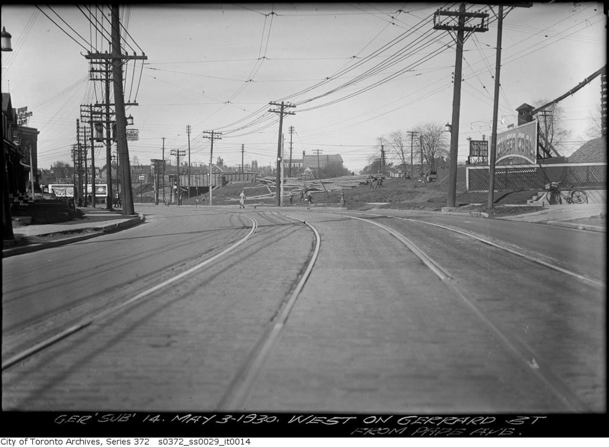
Morley Avenue and Gerrard Street fill operations, April 28, 1912
Morley Avenue and Gerrard St fill April 28, 1912
Looking east across Woodfield Road (then called Morley Avenue) towards Coxwell. Ashbridges Creek is in the deep ravine. A culvert has been installed under Gerrard Street to carry the creek south.
City of Toronto Locomotive No. 6, Morley Avenue fill, July 18, 1912
Workers will install a cement artificial creek about 18-30 metres below the surface. They will then fill in the ravine with sand.
Filling in Ashdale Ravine, Morley Avenue (Woodfield Road), July 18, 1912
A miniature steam locomotive (a dinky), and miniature rail cars (dinky cars) will carry sand dug out from the underpass on Coxwell Avenue along a temporary narrow gauge set of tracks to Woodfield Road.
Dinkies for Civic Car Line Toronto Star, August 18, 1911
Dinkies at work, Canadian Courier, October 18, 1911
Gerrard car line construction, Toronto Star, November 16, 1911
The culvert crosses Gerrard where the Lahore Tikka restaurant is today.
Looking west along Gerrard Street from Woodfield Road over the filled in Ashdale Ravine, July 15, 2019 photo by Joanne Doucette
The photo from just before the Pandemic was shot looking west along Gerrard Street across the landfill and over the buried Ashbridge’s Creek.
Gerrard St E construction, October 11, 1911 (Colourized)
Ashbridge’s Creek is now two creeks: the creek in the concrete sewer pipes and a groundwater creek flowing through the soil and sediment outside of the concrete sewer culverts.
Cement mixer and labourers, Gerrard Streetcar line, July 6, 1912
Cement mixer and labourers at work, Greenwood to Coxwell Avenue, Toronto Star, November 8, 1910
Morley avenue (Woodfield Road), Globe, December 28, 1912
The creek began in springs near Michael Garron Hospital.
Flooding Gerrard and Coxwell, Toronto World, November 10, 1913
It flows across Danforth Avenue, across the tracks at Rhodes Avenue and diagonally under the Roden school yard.
Lost Creeks 1909 Topographical map with labels
It crosses Woodfield Road, half way between Fairford and Gerrard.
Believed to be an early photo of Ashbridges Creek from around 1912, just before it was put under ground in pipes.
From there it continues on a diagonal to cross just west of Highfield. It flows south, under the Duke of Connaught school yard, and crosses Queen Street where the Russell streetcar barns are. From there the hidden groundwater creek makes its way south to the lake.
Route & Car barns, Toronto Star, December 11, 1912
One fare system, Civic Streetcars, Toronto Sunday World, February 8, 1914
Civic car line, Toronto Star, December 16, 1912
First Gerrard Streetcar, December 18, 1912, leaving from the foot of Redwood Avenue, heading east.
Ticket, Civic car line, Toronto Star, December 19, 1912
Toronto Civic Railways Car No. 3 – February 24, 1913
Cherry Beach looking over a rolling Border Terrier to the Leslie Street Spit
East Gap at Toronto Island – 1953
Sand pump east of Eastern Gap – Oct. 18, 1935 A pump is mounted on the dredge. Sand is sucked up at one side of the barge to deepen the Eastern Gap. At the same time, the sand sucked up is discharged through the long pipe to be deposited near the natural sand bank, building it up to create what we now know of as Cherry Beach.
Sand pump east of Eastern Gap – Oct. 18, 1935 This process had been used by the City of Toronto since the 1890s and accelerated during World War One and the creation of the Eastern Industrial District, now known as the Portlands.
Sand pump east of Eastern Gap – Oct. 18, 1935 The Eastern Gap had to be constantly dredged to keep it open for traffic as the offshore currents brought in sand eroded from the Scarborough Bluffs.
Sand pump east of Eastern Gap – Oct. 18, 1935, looking west towards Ward’s Island. The dog park is in this area now and the remains of the lighthouse and jetty remain, albeit with more debris and sandbar willow, goldenrod and other plants, both native and non-native, reclaiming the construction debris for Mother Nature and the pups.
Sand pump east off Eastern Gap – Nov. 23, 1935
Sand pump east of Eastern gap – Nov. 23, 1935
Beach near sand pump east of Eastern Gap – Nov. 23, 1935
Sand pump east off Eastern Gap – Nov. 23, 1935
Queen Street East crossing looking north – [1890s]
Queen Street East at the Grand Trunk Railway crossing by Degrassi Street. View is looking north-west on Queen Street East.
The north side of Queen Street East near Degrassi Street, facing the Grand Trunk Railway’s Riverdale Station.
The north side of Queen Street East facing McGee Street, adjacent to the Grand Trunk Railway’s Riverdale Station, visible on the left of the image.
The north side of Queen Street East at the Grand Trunk Railway crossing by Degrassi Street. View is looking north-east on Queen Street East. Visible in the background is the Dunlop Rubber factory.
Queen Street East and Degrassi Street. View is looking north-west between 1920 and 1926
While researching material for an upcoming book on the history of Toronto’s golf courses, I found myself with a huge amount of material even for one small golf course — that on Mugg’s Island. Every writer has to know how to cut and what to leave in and then find an editor to cut even more! Some suggest that I should just “stick to golf” and leave out some of the more controversial aspects of sports history such as anti-Semitism, racism and sexism. Some suggest that to explore these is just “identity politics”. Even the largest social media site will not allow me to publish what I’m putting here today as they consider it offends community standards. But I’m plunging ahead because I need your feedback. Read on!
Toronto Island – January 1, 1917
Mugg’s Island, January 1, 1917
Mugg’s Landing, the vaudeville show, Brantford Daily Expositor, October 3, 1888
“It was a group of campers, in fact, who gave Mugg’s Island its name. In the 1880s four carefree bachelors – Chester Hughes, Jack Crean, Warring Kennedy and Jack Lye (who later became the Monarch of Mugg’s) – pitched their tent near one William Burns’ icehouse. The lads used to row, paddle or sail to work each day. One time, when rowing back from the city, they spotted a sign floating on the water, which had been tossed out after a play at the “Royal” that had closed. They towed the cast-off sign to their tent site and proudly erected it. The name of the play – and subsequently of their camp and its wild little island – was “Mugg’s Landing.”[2]
North from Mugg’s Landing, April 8, 1911
In the 1890’s John George “Jack” Lye, and his friends got permission to build a cabin on Mugg’s Island. The young men also built their own nine-hole golf course there – cutting holes in the sand with their jackknives just as Toronto Golf Club members were doing in the East End. The Mugg’s Island golfers were young, but not poor boys. They were the sons of Toronto’s elite, some of whom belonged to the Toronto Golf Club, like Colonel Sweny and the Cassels, also had summer cottages on the Island. Lye recalled, “A group of young fellows who chummed around together, including our leader Warring Kennedy and myself, were asked by Warring’s dad, Mayor Kennedy, to build a camp on the island and to keep away undesirables. This we undertook to do.”[3]
Muggs Island, 1921
However, after World War One, Mugg’s original stopped coming, leaving “King John” Lye to rule Mugg’s Island alone. The golf course he and his friends laid out had not been used since the young men went off to war in 1914-1918. Some, such as Chester Hughes, never came back, dying in the trenches. Their course disappeared into the tall grass and poison ivy. Recalled young golfer George Hevenor, “It wasn’t really golf. We just chipped balls out of sand into tin cans.”2Later, as a member of the Summit Golf Club, Hevenor won the club championship four times. Alongside representing Canada on two occasions as a member of Canadian Seniors Golf team, Hevenor also became a director of the Royal Canadian Golf Association. Not bad for a kid whose early experiences of the game were fostered on Mugg’s Island.
However, the story was far from over. Islanders have a well-earned reputation for being persistent. If at first you don’t succeed, try and try again – at least six times!
In 1928 a spokesman for Stanley Thompson, proposed a nine-hole public course on Mugg’s Island at a cost of $45,000. The course could also be expanded to 18 holes by extending the layout across Long Pond using a pull-boat to get golfers across, but plans fell through.
Centre Island’s Manitou Hotel, December 8, 1945 TPL Collection
In 1930 William James Sutherland, secretary of Centre Island’s Businessmen’s Association, again proposed building a nine-hole course on Mugg’s Island to the City of Toronto Parks Committee. Sutherland owned the Hotel Manitou “for Gentiles of refinement” and the proposal was on letterhead with that slogan on it. Alderman Sam Factor immediately tackled the anti-Semitism. By this time the Jewish population of Toronto was about 50,000, and not to be ignored. Other city politicians opposed the proposal. Nevertheless, the City of Toronto Parks Commission negotiated with golf architects Millar and Cumming to lay it out.
Sam Factor, newly elected alderman, Globe, January 2, 1929
That spring the T.T.C. opened a miniature golf course at Hanlan’s Point. It lasted only one season.
Three years later “Gentiles Only” signs went up at Balmy Beach and Jewish and Italian men and women fought Nazis and Swastika Club members in a public park — the infamous Christie Pits Riots. That year Hitler became Chancellor of Germany and the first Nazi concentration camp, Dachau, opened.
Gentiles only Toronto Island sign Toronto Star, March 29, 1930
Toronto Star, August 2, 1933
Anti-semitic riot at Christie Pits park – August 16, 1933
Discriminating Signs Banned on Island, Globe, February 4, 1934
By 1936 when the Toronto Island Ratepayers’ Association met in Hotel Manitou and Sutherland again lead the move to build a nine-hole course on Mugg’s Island, Sam Factor was Toronto’s only Liberal Member of Parliament. Lobbying for the course continued through 1937, but anti-Semitism left a sour taste that the City of Toronto just wouldn’t or couldn’t swallow as World War Two loomed on the horizon. However, other golf clubs also barred Jews as well as Black Canadians and other visible and not so visible minorities.
Toronto Star, June 23, 1937
In 1939 George McCordick proposed building a 3,000-yard nine-hole course and a clubhouse on Mugg’s Island. The Parks Committee turned him down. By this point “King John” Lye was old. The golf course he and his friends laid out had not been used since the young men went off to war in 1914-1918. Some, such as Chester Hughes, never came back, dying in the trenches. By 1944 when King John Lye died there were few traces of their Mugg’s Island course left.
In 1949 Parks Commissioner Walter Love began negotiating to buy the old York Mills golf layout for a municipal golf course.The Parks Commission considered other sites, including Mugg’s Island, but a bridge would be needed to Centre Island and the plan fell through.
In 1956 the new Metropolitan Toronto took over control of the Toronto Islands. There was again a proposal that Mugg’s Island be turned into a golf course and, again, it got nowhere.
Miniature golf, Centre Island, June 1964
In 1963 Metro Parks Commissioner Thomas “Tommy” Thompson created an amusement park at Centre Island with a miniature golf course. This mini-putt still operates.
In 1884 when the area was still Leslieville there was no Brooklyn Avenue and it is not listed in the 1885 Polk’s City Directory or the 1886 Polk’s City Directory. A real estate company owned by James Armstrong and John J. Cook sold most of the property on the street. Brooklyn Avenue was named for a small creek that ran down through it, across Queen Street and down to Ashbridges Bay. Brickmakers followed the banks of these rivulets to look for deposits of the blue clay that they could use to make good bricks. Brooklyn Avenue ran through two brickyards. John Russell owned the brickyard on the west side of Brooklyn Avenue and David Wagstaff owned the brickyard on the east side.
John Russell Globe, July 5, 1902
James Armstrong, Brooklyn Avenue, pavement, Globe, May 4, 1886
Lots sold on Brooklyn Ave, Globe, June 24, 1886
Lots sold Brooklyn Ave, Globe, February 15, 1887
Lots sold Brooklyn Ave, Globe, March 26, 1887
Lots for sale, Armstrong & Cook, Globe, November 8, 1887
Lots for sale, Globe, February 18, 1888
lots for sale, Globe, July 21, 1888
Lots for sale cheap, Globe, August 27, 1892
James Armstrong, Armstrong & Cook dead, Globe, October 13, 1919
Both John Cook and James Armstrong died very wealthy men. James Armstrong, Armstrong & Cook, will, Globe, December 4, 1919
Realtor mourned John J Cook, Armstrong & Cook, Globe, June 5, 1933
The women of the family rarely get a mention. She was an exception and must have been an exceptional woman. Mrs John J Cook obituary, Globe, March 28, 1935
Maps
1851 map showing the area before the construction of the Grand Trunk Railway (now the GO Train line). The Holy Blossom Cemetery is on Pape Avenue.
1860 map shows the new Grand Trunk Rail line. George Leslie’s nursery is in the lower right, but he had not yet made his fortune and purchased the Widmer property on the west side of Jones Avenue or the Beaton property on the right.
Brooklyn Avenue doesn’t yet exist in 1884
Goad’s Atlas Plan, 1884
Plan of the City of Toronto 1885 Brooklyn Avenue area. Three creeks ran through the area. Holly Creek on the left crossed Gerrard and Carlaw Avenue. Leslie Creek in the middle gave Brooklyn Avenue its name — “brook” meaning a small creek and “lyn” from “linn” — A waterfall or cataract, or a ravine down which its water rushes https://en.wiktionary.org/wiki/linn#English The creek on the right is Hastings Creek.
1888 Plan of the City of Toronto and Suburbs by Penson, showing a new street: Brooklyn Avenue
Assessment Roll, Brooklyn Avenue, 1897
1890 Assessment Roll p. 47
1890 Assessment Roll p 48
Often property owners were slow, sometimes very late, in paying their property taxes. Brickyard owners and those with connections at City Hall made a practice of this at times. John Russell found that sometimes too late was really TOO LATE. When he didn’t pay his taxes on one of his many brickyards, the City of Toronto seized it for back taxes and sold it to create an industrial park on Carlaw Avenue that still stands today albeit re-invented as condos and boutiques. Russell fought it all the way to the Privy Council in London, England, but lost. Below is a list from the Toronto Star of November 4, 1897, of those property owners who were in default of their taxes. Many were absentee landowners, holding on to lots as investment opportunities.
Tax arrears, Toronto Star, November 4, 1897
Assessment appeals, Armstrong & Cook, Globe, June 9, 1897
From 1836 to 1837 workers had straightened and planked the Kingston Road. It became a toll road, providing a reasonably good route for transporting products in and out of Toronto. Here, in 1842, Scottish gardener and tree grower, George Leslie, leased 20 acres of land from Charles Coxwell Small for a 21-year term. George’s landlord, Small, a member of the Family Compact and Clerk of the Crown, was the owner of extensive lands in the area. (Coxwell Avenue is named after him.) Small may have thought he got the better of the deal when he found someone foolish enough to lease his 20 acres of mucky swampland on the shores of Ashbridge’s Bay. The Toronto Nurseries was built on a tamarack-covered swamp (Larchmount Avenue recalls this). These 20 acres of rich black mud were the core of his nursery which would expand to 200 acres, the largest in Canada. George Leslie did not buy that land until the lease ran out in 1863. Then Small demanded an exorbitant price from Leslie and apparently got it. George Leslie valued that soft, rich dark muck and others recognized its worth, as shown in the Annual Report of the Bureau of Forestry for the Province of Ontario.
The memory of the tamaracks and reeds remained for decades. Marigold Gardens, the subdivision on Toronto Nurseries land, was nothing but “bulrushes and swamps”. Ward 8 News. “Short Stories of Leslieville” in Ward 8 News, February 9, 1979. Marigold Gardens is one street in the former Leslie Gardens subdivision built by realtor and contractor H. Addison Johnston.
Leslie Nurseries 1884 I’ve added notes and marked where the creeks were.
George Leslie attributed to John McPherson Ross ca 1907. John McPherson was a poor Scottish boy when George Leslie took him on as an apprentice. He rose to become foreman of the Toronto Nurseries and Leslie’s right-hand man. After George Leslie died, his sons made unwise investments, became embroiled in scandal, and lost the Toronto Nurseries. Most of it become housing, but a small portion along Eastern Ave continued under the ownership of John McPherson Ross. Caroline Avenue at the west side of Leslie Gardens is named after George Leslie’s first wife.
George Leslie died on June 14, 1893. George Leslie left a large estate with considerable real estate, including properties on Queen Street East, on Jones Avenue, on Curzon Street, on Eastern Avenue, and on Leslie Street, worth almost $115,000 in 1893. Not long after George Leslie died most of the Nurseries was sold. Before long most of the land was mortgaged to the Gooderhams and sold off around 1910. Some Leslie descendants still remember the grudge against the Gooderhams who “took” their land; others remember how like prodigal sons, John Knox and his brother George Leslie Jr., between the two, spent like millionaires, gambled, drank and womanized. The Leslie family’s loss was another family’s fortune.
Success Came by Giving People Made-to-Order Homes, The Canadian Builder and Carpenter, April 1916
H. Addison Johnston had made a name for himself building high-end homes in the Beach. He gained a reputation quality — “honestly built”… “genuine Johnston-built homes.” Toronto Star, March 1, 1919
The economy was still in the grip of a depression and Toronto City Council was hesitant about incurring more costs to provide work. Councillor Gibbons nailed it when he said, “These men are going hungry. We have been at this since last September and nothing done.” The municipality had few choices: make-work projects, welfare (the dole) or hungry, angry veterans who had already demonstrated that they could and would riot. But Council took a risk and agreed to put the sewers for Leslie Gardens out to tender. Addison Johnston was a canny man and an experienced builder and developer. Toronto Star, February 2, 1922
Leslie Gardens sat on the easternmost section of George Leslie’s Toronto Nurseries. A semi-bungalow was a house with a second story with slanted walls to the rooms –not full head-height walls. Globe, December 16, 1922
Globe, January 24, 1923
The Roaring Twenties was beginning to roar finally after the economic downturn that followed World War One. Globe, February 27, 1923
Leslie Gardens School construction, Globe, March 20, 1923
City Council approved laying the sewer system for Leslie Gardens at a cost of $63,618. Globe, April 17, 1923
Addison Johnston’s house-a-day plan explained. Larchmount was a new street in 1923 and built up quickly as was the rest of Leslie Gardens. Johnston used pre-fabricated or kit homes and an assembly line approach to putting them up. The fact that they were put up quickly does not mean that the construction was shoddy. However, because Leslieville Gardens was built on an old marsh at the edge of Ashbridge’s Bay, some of the houses may have settled and/or may have problems with wet basements. The black wet marsh mud was great for George Leslie’s nursery but didn’t necessarily make for the best residential building sites. Globe, May 10, 1923
Sales Larchmount Avenue Globe June 4, 1923
Globe, July 31, 1923. A building boom took off in the spring of 1923 after a short but sharp post-war depression and houses at 66, 68, 72 and 84 Larchmount Avenue sold quickly.
Looking east on Moseley Street with the Leslie Gardens Service Station on the left.
“The market for small house properties continues to be very active.” Toronto Real Estate News Aldridge and Leslie Gardens, Globe, July 21, 1923
This is a photo of the Leslie Gardens gas station on Eastern Avenue and Mosley Street, just west of Leslie Street. The view is looking east towards Leslie Street. The Leslie Garden’s Service Station’s address was 780 Eastern Avenue
42, 60 and 70 Larchmount Avenue were sold. The lots were narrow with 16 feet of frontage on the street but long at 100 feet. Toronto Star, July 26, 1923
photo from the 1970s
Globe, July 31, 1923
Leslie Gardens Service Station, Imperial Gasoline, ca. 1929
Toronto Star, August 13, 1923. Most of the new home buyers worked in the factories along Eastern Avenue and up Carlaw. To supplement their income and pay a portion of the mortgage, many let rooms or took on boarders.
Globe, August 17, 1923
Leslie Gardens, 1970s
The school was completed but the Board of Education needed to level the playground and parking area. Globe, October 31, 1923
Leslie Gardens, 1970s
Leslie Gardens school opens, Globe, December 4, 1913
Leslie Gardens School, 1923 (probably on the opening day) and Bruce Public School, 2014
Leslie Gardens 1924 included the east side of Caroline Avenue, Larchmount Avenue, Berkshire Avenue, Rushbrooke Avenue, Marigold Avenue (now Marigold Gardens) as well as the triangle of land at Eastern and Leslie Street.
Building the infrastructure of the Roaring Twenties, Toronto Star, January 18, 1924
photo from the 1970s
Leslie Gardens house for sale, Toronto Star, June 13, 1924
Leslie Gardens School was renamed Bruce Public School, June 28, 1924
Globe, July 1, 1924
Leslie Gardens, 1970s
Globe, October 2, 1924
Leslie Gardens, 1970s
For rent Globe, October 29, 1925. Some of the houses in Leslie Gardens were built for investment income and rented out.
Leslie Gardens, Toronto Star, March 11, 1926. In the early days of subdivision development, an investor or group of investors or sometimes a real estate company bought up a block on land and sold sections of 6-12 houses to builders. This was not true for Leslieville Gardens. Most of the houses there were built for and by Addison Johnston. However, 570 feet of street frontage was a sizeable amount of land enough for 20-30 houses.
Union Station and the Viaduct Toronto Star, December 31, 1924
Union Station and the Viaduct Toronto Star, December 31, 1924
Union Station and the Viaduct Toronto Star, December 31, 1924
Canadian Railway and Marine World September 1913
Toronto Star, Friday, July 11, 1924
Viaduct work, destruction of stores, Queen & De Grassi. – December 9, 1925
Viaduct work, destruction of houses, Strange St.. – December 9, 1925
Viaduct work, fill on east back of Don. – December 24, 1925
Viaduct, Riverdale, trestle for fill. – October 7, 1926
Construction Toronto Viaduct Toronto Star Oct 9 1926
Construction Toronto Viaduct Toronto Star Oct 9 1926
Viaduct construction Globe, Oct. 20, 1926
The first train on the new viaduct, Globe, September 24, 1927
Viaduct opening, Canadian National Railways crew: Brakeman Ryckman, Baggageman Cox, Conductor Huff, Engineer Brown, Fireman Franks. – January 21, 1930
A pulmonator, 1913 being used to revive a victim
Carbon monoxide poisoning, McGee Street Toronto Star, December 30, 1941
Carbon monoxide poisoning, McGee Street Toronto Star, December 30, 1941
Old Coal furnace photo by Peter Baer ShareAlike 2.0 Generic (CC BY-NC-SA 2.0)
Carbon monoxide poisoning, McGee Street Toronto Star, December 30, 1941
Carbon monoxide poisoning, McGee Street Toronto Star, December 30, 1941
Carbon monoxide poisoning, McGee Street Toronto Star, December 30, 1941
Eastern Avenue Bridge, December 30, 1932
Do you enjoy reading local history? Would you like to know more about the past of your neighbourhood? If you do, please read this.
Most, but not all, people who research and write about the history of neighbourhoods do not have advanced academic degrees, such as the very Harry Potterish picture of Professor John Ashley Soames Grenville, historian, taken in 1950 (Public Domain) featured above. The local historian is, like me, an amateur not a professional.
Many academic historians look down on local historians as muddlers who don’t get the big picture. And sometimes that is true, but often not.
Local history is a very democratic kind of practice, drawing on community histories (e.g., in the local history collections of our branch libraries), family history, genealogy and oral history. The best local history relies on meticulous and careful use of original and secondary sources as well as ongoing discussion with professional historians. But local historians have limited resources. Not everyone has the money to get those letters behind the name. We do not have access to the records, the peer-review process, conferences and journals of the academic historian. We rely on sources and our works are published informally – on blogs, Facebook groups, etc. My peers are those who read my posts and blogs and respond. And I am very grateful to you. But I rely on sources and sources are not always right.
There are basically two kinds of sources – primary sources and secondary sources.
A Census is an example of a primary source.
Primary Sources
Primary sources are things like newspaper accounts, letters, marriage licenses, death certificates, baptismal certificates, tax assessment rolls, etc. They are usually reliable but have to be “handled with care”. Sometimes original sources contain simple mistakes. Sometimes the originator actually lied. Sometimes they didn’t know what they were talking about. Not so different than today. Usually, the records are biased in ways that we now recognize – racist, sexist, etc.
This is an example of a secondary source. The writer of the caption was not there in 1783 when King George presented the fire engine. Fire Engine, Maclean’s, September 1, 1929
Secondary Sources
Secondary sources are records written after the event. The writers rely on records that they might not understand or they may not have researched adequately. Or they too can intentionally distort the truth, often with “little white lies” that romanticize things – the “good old days”, etc.
The story of my family’s mixed MI’kmaq and European ancestry is oral history passed down by word of mouth through the generations depicted here. Family photos: Susan Brewer (nee Doucette), Thomas Leo Doucette and Agnes Lucy (nee Devenish) and Thomas Vincent Doucette.
Oral History
And then there’s oral history. Memories fail and stories passed down often begin to stray from the facts though there’s usually a core that can be verified through researching primary and secondary sources – which leads me back to where I wanted to go.
An original baptismal record confirming the Indigenous roots of my family
Why am I saying all this?
When the Leslieville Historical Society wrote up a plaque to the Underground Railroad two years ago, we made a mistake. The quote didn’t begin to appear until 2007. We relied on secondary sources, even a leading U.S. politician, and the Harriet Tubman Monument and other apparently reliable sources for the following quote:
A contemporary illustration of Harrriet Tubman
“Every great dream begins with a dreamer. Always remember, you have within you the strength, the patience, and the passion to reach for the stars to change the world.” -Harriet Tubman (1822-1913)
But, as a Toronto historian brought to my attention, Harriet Tubman said no such thing.
Here’s the back story. We did our best three years ago in terms of due diligence, believing our sources were valid and checking with various authorities, including some friendly folks with PhDs. We also ran the wording by the Ontario Black History Society which suggested some changes which we duly made. They shared generously of their time and sent representatives to the unveiling. While they gave us the go-ahead, the responsibility lies with us and more particularly me.
Here’s a quote from Harriet Tubman in a book from 1869 that we could have/should have used.:
“When I found I had crossed that line, I looked at my hands to see if I was the same person. There was such a glory over everything; the sun came like gold through trees, and over the fields, and I felt like I was in Heaven”.
Harriet Tubman
Sometimes, as when I wrote a small paragraph about Black World War one hero, Jeremiah Jones seven years ago, I did not have access to primary sources. I found nothing in the news of 1914-1920 about him and could not access his military records as they were not digitized yet.
So, I followed the lead of the CBC and noted that he was wounded at Vimy and Passchendaele. The journalist apparently relied on family history as recounted by a descendant, Adam Jones.
Jones was wounded at Vimy Ridge but not the other battle. (Yesterday I downloaded his military records online and double-checked.)
The Historian as Detective by Matt (CC BY-NC 2.0) FlickR
We work diligently to uncover lost histories but ask for fairness and respect for the work we get right and the service we provide to our communities. It is fair to ask for some courtesy when our sources fail us.
Public shaming is far from helpful and comes across as an attempt to silence. If local historians were to be silent, then the stories of ordinary families on ordinary streets would be lost. And I for one think that would be a shame because all families are extraordinary and all streets have stories to tell. We need to respect each other.
To quote a perceptive article:
“The academic historian is the discipline expert. They therefore have a responsibility to provide leadership. They should inspire amateur historians to increase their standards of scholarship. This needs understanding, trust and encouragement from academics. Not paternalism.”
This photograph is from the Schlesinger Library on the History of Women in America and has no known copyright restrictions.
Afterword
A Local Historian & Oral History
“Biography: Kathleen Adams, a graduate of Atlanta University in 1911, taught in the public schools of Atlanta for about 34 years, and also at the Carrie Steele Pitts Home, an institution for the care of orphans. She retired from teaching in 1957. A member of one of the prominent Black families of Atlanta, Mrs. Adams showed an early interest in history. She has preserved the history of her family in documents and memorabilia and has made tapes for the local historical society on the history of the Atlanta public schools. At the time of her interview, she was the historian and oldest active member of the First Congregational Church in Atlanta.
Description: The Black Women Oral History Project interviewed 72 African American women between 1976 and 1981. With support from the Schlesinger Library, the project recorded a cross section of women who had made significant contributions to American society during the first half of the 20th century.
Photograph taken by Judith Sedwick
Repository: Schlesinger Library on the History of Women in America.
In the distance can be seen the Canadian Chewing Gum factory, makers of Chiclets. The photographer took this shot from the railway line into the backyards during the construction of the raised railbed that they called “the Toronto Viaduct”.
This scene shows the raised rail bed under construction and the old rail bed next to it, as well as two women taking a dangerous but commonly-used shortcut.
Disputing their property taxes seemed like an annual game in the old East End, including Leslieville. Globe, Nov. 9, 1895
Rolph Clark Stone’s employee newsletter, November 9, 1948
Horse-drawn fire wagon with water tank, Bloor Street West. – 1912\
Fire Hall # 12 Bolton Avenue
Three of the many firefighters killed in the line of duty, The History of the Toronto Fire Department, 1924
Horse-drawn fire reel, Bloor Street at Queen’s Park Crescent. – [1912?]
Horse-drawn fire wagon with hose and water tank. – [1910?]
Three of the many firefighters killed in the line of duty, The History of the Toronto Fire Department, 1924
Three of the many firefighters killed in the line of duty, The History of the Toronto Fire Department, 1924
Horse-drawn fire reel, Avenue Road. – [1908?]
Horse-drawn fire wagon on Avenue Road. – [ca. 1908]
Horse-drawn fire wagon with ladder. – [ca. 1907] Item consists of one photograph, possibly showing North Toronto Fire Department on Montgomery Avenue. *** Local Caption *** Item consists of one photograph, possibly showing North Toronto Fire Department on Montgomery Avenue.
HORSE-DRAWN LADDER WAGON courtesy of Chuckman’s Other Collection
Palmolive site with Wrigley Bldg & Rolph Clark Stone background. Aug. 2, 1917. Library and Archives Canada.
North Wrigley Building, Dec. 5, 1916. Library and Archives Canada.
South Wrigley Building. No date. Probably spring, 1916. Library and Archives Canada.
Goad’s Atlas, 1923. Dundas Street was not built through the East End until the mid-1950s.
I wonder how many in our neighbourhood have Red Seal builders in their family trees?
There is a small clue in this rather mundane article from the Toronto Star of October 25, 1917.
Lewis Rootham was a contractor who built many of the houses on the lower of Woodfield, Connaught and neighbouring streets. But he wasn’t just any old kind of contractor: he was a Red Seal builder. (see article below)
Toronto Star, May 27, 1935
Some years ago, I had the opportunity to speak with one of his descendants and here is a transcript of part of that conversation:
“Lewis Rootham built the house in the early 1900s. He talked about the area being like old English countryside at first with grass and creek that ran into Ashbridges Bay. His dad and uncle used to swim there. He talked about Ashbridge who were said to be United Empire Loyalists with connections to royalty. The Ashbridges were deeded a lot of land, but my dad thought Jesse Ashbridge a bit odd because he cut the grass in the rain. My dad said the whole atmosphere of the neighbourhood changed with the relentless advance of civilization. He cited three major steps in the area’s development. First, stores opening on the south side of Queen Street, bringing more people to the street. Next, came the building of the TTC car barns and yard. That changed the atmosphere from that of the English countryside to mechanical. Then, the building of the big school north of the Ashbridges place, the Duke of Connaught, started a building boom. The Ashbridges kept 200 feet of frontage [on Queen Street]. He described the houses on one side of Woodfield Road (the Rootham house is at 42 Woodfield Road) as being low-class row houses, but said the other side had pretty good houses. He said his grandfather’s house was big, but unique in design because it had multiple levels. Master, living and front hall were on one level, but you went down two steps to dining and kitchen; up to bath and two bedrooms and up again to two more bedrooms. It was a great big house with only one bathroom. He remembers the fireplace as marvellous and the wood panelling and brickwork, all in classic English styling. He said times were tough later and his grandfather replaced the backyard with garages he could rent out to people with automobiles to have some money. He said the driveway was cinder and he was always getting hurt on it.”
I love collecting these old postcards. Most are from my collection though some are no longer in my file of old fragile paper things. Due to the rarity many go from that drawer in my desk to libraries and archives. Some I also give away as Christmas stocking stuffers for friends. I should also note that in many cases, rips, tears, fingerprints etc. have been carefully removed. In my youth retouching photos was one of my occupations. Joanne
Balmy Beach Toronto 1900
There was no colour photography as we know it at the beginning of the 20th century. Postcards were carefully hand-painted, usually by women. While this makes every postcard a little different, it also means the quality of painting varied greatly. Some were pretty slapdash; others meticulously done. Most of these postcards have lived quite a life after they left the painter’s easel. Some were put away in drawers and, in 2021, are pristine. Most were left in sunlight and yellowed as the cheap paper they were printed on acidified. Some were handled more or less lovingly, with worn corners, tears, fingerprints and smudges. Others were mailed and got worse handling and all too often have traces of postmarks on the front. It is one of the most inexpensive but enjoyable of hobbies.
Balmy Beach Club, Balmy Beach Park, foot of Beech Ave., 1900
This is the actual black and white photograph from which the postcard was produced and it is easy to see “how much was lost in translation.”
Postcard Balmy Beach Club 1920s
It seems that painter was not up to the challenge of the dog in the centre or was interrupted. I think of this as “The Ghost Dog of Balmy Beach”, gone but perpetually happy and wet.
Leslie House at Jones and Queen (north east corner) torn down Telegram October 20, 1923
Globe, May 6, 1893 showing a separate entrance for his office
George Leslie’s house at the north east corner of Queen and Jones (undated, but probably early 1920s). The verandah and main entrance faced on Jones. Originally the main entrance was on Queen Street.
The stores that replaced the Leslie house, 1986
Goad’s Map 1910. I have added labels.
Edvard Munch, Self-Portrait of the Artist with the Spanish Flu (1919)
More Flu deaths at the training camp at Niagara-on-the-Lake, The Gazette, October 14, 1918
Personal protective devices, home-made by medical staff themselves
Flu deaths in Ontario The Gazette, Oct. 14, 1918
Medical authorities warned the public…
…but early on the information was not always correct, undermining credibility
American anti-mask rally, 1919 Public Domain
Edvard Munch, The Scream
Sled dogs rescue man Globe, February 1, 1919
Andrew Coulter, 128 Curzon St Toronto Star, March 12, 1919
Andrew Coulter, 128 Curzon St Toronto Star, March 12, 1919
Many simply stayed home and coped as best they could
People wiped surfaces rigorously with strong disinfectants, Saturday Evening Post, March 29, 1919
Promises, promises
Statistics deaths in Toronto for 1918, Toronto Star, May 15 1919
In this the second wave, hospitals quickly filled up again and the shortage of nurses was again acute.
The Pandemic’s impact on the supply chain, Globe, January 2, 1919
Flu back in Toronto The Gazette, Jan. 12, 1920
Mixing different kinds of vaccines to combat the Pandemic, The Canada Lancet, April, 1919
The official voice of Canadian doctors, Canada Lancet, supporting vaccination, November 1919
Dr. Charles Hastings, appointed by the Province of Ontario and not answerable to Toronto City Council, strongly supported vaccinations
Anti Vaccination League, Toronto Star, November 18, 1919 Dr. Hastings, the City’s Chief Medical Officer of Health, supported compulsory vaccination. Vaccines against influenza had been invented but were not widely available.
Anti-vaccination Rally on the Steps of the Toronto City Hall
Globe, November 20, 1919
Globe, November 20, 1919
Edvard Munch, Self-Portrait of the Artist after the Spanish Flu 1919
Inside cover, Maclean’s, April 2, 1955: a cartoon criticizing people who diagnosed themselves and picked and chose new medicines according to their misconceptions
page 1033 of Ontario Sessional Papers, 1919, No.26-41 Public Domain
If you lived in Toronto in the fall of 1918, you probably had a great sense of hope for a better future. The Great War to end all Wars seemed to be coming to an end. The Allied forces, including Canadian battalions, were sweeping back Germans along the Western Front.
Canadians returning victorious from The Battle of Courcelette, September 1916, Library and Archives Canada
Yet the men in the trenches were worn out. Casualties, both dead and wounded, were still high. The country was split over conscription and recruitment and training were ongoing. Men packed into military camps and aboard troop ships to Europe just as returning soldiers, mostly wounded, packed ships heading home.
First aid being rendered to wounded at Courcelette September 1916
Conditions for civilians “Over There” were horrendous as refugees tramped the roads, families cowered in basements and starvation stalked the towns and countryside.
The Survey April-September 1920, p 350 Public Domain
And rumours of a new mystery illness had been appearing in letters from overseas and in the newspapers since the previous winter. China was diving into an epidemic and sick soldiers were beginning to die — Americans, British, Canadians, Australians, Indians, Africans, Russians, Germans, Austrians, Italians. The new illness seemed to be a form of the flu that once it took hold often progressed to a deadly pneumonia in an age without antivirals or antibiotics.
Globe, Jan. 5, 1918
Globe, January 17, 1918
In Toronto, cases of pneumonia began to appear here and there in the papers. Often the victims were young and healthy with no preexisting conditions. These cases were not yet identified as influenza. But those who read the paper knew something dark was on the horizon. The military would be the vector, flu’s main line across the globe and to Toronto.
Flu kills Ulster team player Toronto Star May 13 1918
Flu in Polish camp at Niagara Globe, Sept. 18, 1918
In mid September cases of influenza began to appear among the Polish soldiers at the Canadian Military training camp at Niagara-on-the-Lake. “Lieut.-Col. Le Pan does not anticipate any serious results from the epidemic.” Authorities seem to take the deaths of Josef Zabezyk and Kazinners Kolonaki, both Polish Americans, the first deaths, lightly. But were officials simply trying to reassure the public? This was wartime and the army authorities knew full well what was going on in Europe. Propaganda was “part and parcel” of war.
Some propaganda was worse than others,: a lot of it was sexist and much of it was racist, though Canadians of European ancestry wouldn’t have seen it that way at the time. Indigenous people maybe not so much. I wonder what the Cree syllabics say.
A week later the flu was in Toronto, but no deaths had yet been identified. Chief Medical Officer of Health, Dr. Charles Hastings, offered guidelines to help prevent infection and spread of the new illness. Some are familiar to us 103 years later: avoid crowds, wash your hands, get outside (breathe pure air). Others seem downright weird: breath through your nose, chew your food well, “don’t let the waste products of digestion accumulate” (don’t be full of shit), avoid tight shoes. But the Pandemic of 2020-2022 offers advice just as useless and more dangerous: inject yourself with chlorine bleach, take pills vets prescribe for cows and horses, don’t get the COVID vaccine, diagnose and prescribe for yourself and your family, etc.
Toronto Star, Sept 23, 1918
Toronto Star, Sept 23, 1918
By September, Toronto had its first official flu death. Some schools were in quarantine as were some military centres in the city. Dr. George W. Ross was prescient.
Keep Away From Coughers Take No Chances, Cough Drop ad to prevent flu, Public Domain
People tried everything they could think of including cough drops to prevent getting the flu. They opened windows on streetcars and in homes, but dark jokes began to spread.
We opened the winda
And in flu Enza.
Masks were initially not recommended and then medical recommended them and soon political authorities mandated them. And some resisted.
Illustrated Current News, 1918, Collection National Library of Medicine Public Domain
Flu, Maclean’s, Feb. 1, 1953 10 0
Public Domain
Pandemic deaths Toronto, Globe, October 3, 1918
Growth was exponential as Toronto entered the October from Hell.
Triaging in Toronto, Vancouver Daily World, Oct. 7, 1918
Flu makes orphan Ivy Avenue, Toronto Star, Oct. 11, 1918
October 12, 1918 Toronto’s Day from Hell
By October 12, the hospitals were triaging, turning away patients they thought might have a chance of survival or just accepting patients on a first-come-first-served basis. Doctors and nurses were not seeing those we would think would be least likely to survive: elderly, frail people and young children and infants. Those who were dying were, overwhelmingly, young and healthy men and women, in all neighbourhoods including older areas in the East End such as Riverside, Leslieville and Todmorden and new neighbourhoods spreading across the farm fields of the Ashbridges, Charles Coxwell Small, the Sammons, Cosburns and others. Even the new cottage communities along the Beach were not spared.
October 12, 1918, Toronto’s Day from Hell, began.
Influenza spreads across Toronto, Influenza deaths Toronto Star, Oct. 12, 1918
Some of the many deaths from influenza at the Niagara Military Camp and the Toronto General Hospital on College Street.
Like now, there simply were not enough trained and qualified doctors, nurses and other staff to care for the seriously ill. Voluntary in this case did not mean unpaid. Those doing the hands-on work of cleaning, feeding, and caring were then and now paid low wages and themselves falling prey to the Pandemic of their time.
Appeal for Volunteers Flu Toronto Star Oct 12 1918
The Gazette, Oct. 12, 1918
A temporary lockdown began.
Lockdown begins, Dr. Hastings, Toronto’s Chief Medial Officer, The Gazette, Oct. 12, 1918
Deaths rise Toronto, The Gazette, Oct. 12, 1918
Dr. Hastings arranged for supplies and beds for overflow facilities. Big business began to move to combat the Pandemic.
No more movies, The Gazette, Oct. 12, 1918
Calgary Herald, Oct. 12, 1918
Even the deeply religious no longer relied on prayer alone.
Baptist Convention cancelled The Gazette, Oct. 12, 1918 1
Record of influenza death at the Niagara Military Camp, October 13, 1918, Burial at St. John of Norway Cemetery
This man kept Thanksgiving by travelling to Toronto and playing billiards on arrival. He read the newspapers…and caught a chill.
Diary entries of Edward G.R. Ardagh, October 14-17, 1918, Archives of Ontario Public Domain
Globe, October 15, 1918
More emergency measures put in places and more volunteers called for.
Toronto Star, October 16, 1918
Ontario Emergency Volunteer Health Auxiliary, October 16, 1918 Archives of Ontario Public Domain
People began confronting those who refused to wear masks in public.
The Evening Star, October 16, 1918 Public Domain
A vaccine was available at the Mayo Clinic in Rochester, Minnesota. Dr. Mayo wasn’t sure if his jab would work for everyone and seemed unaware of side effects when he said, “We are not absolutely sure, except that we know the inoculation can do no harm.” Facilities couldn’t make it fast enough to give everyone the vaccine, but Dr. William James Mayo downplayed the flu, reassuring those who couldn’t get it or couldn’t afford it. Dr. Michael Mayo treats COVID patients today.
Dr. William James Mayo, Mayo Institution (now called the Mayo Clinic)
Dr. Michael Mayo, The Mayo Clinic, 2021
Influenza vaccine, Mayo Clinic, Toronto Star, October 16, 1918
You could buy insurance against influenza, but how high were the premiums?
Toronto Star, October 16, 1918
Globe, October 18, 1918
People quickly came up with new and supposedly improved masks.
Flu mask, Globe, October 18, 1918 Montreal inventor
Toronto Daily Star, 23 Oct 1918 chart
And the numbers continued to rise, but, like now, statistics were hard to gather. But arrangements could be made for free delivery of free sup0plies to the home.
Toronto Daily Star, 23 Oct 1918
Quack cures and fake news abounded, mostly by word-of-mouth. Although the main stream media accepted ads like this, reporters were careful to adhere to the journalistic standards of the day. By and large, their stories were accurate.
Toronto Daily Star, 23 Oct 1918 false news remedy
A lot of people repurposed their Ultra-Violet home machines in 2020-2021. They bought them to disinfect the tubing, parts and masks of their CPAP machines safely and quickly. But many CPAP machines were also repurposed to become ventilators with new computer chips and the addition of oxygen.
Ultra violet machine, Globe, October 28, 1918
They believed the First Wave had crested and November would be better.
This series of photographs will take you on a trip from downtown Toronto to Main Street on the new Toronto Viaduct, a raised railbed that lifted the train high above the city streets, eliminating several of the most dangerous level crossings such as the one at Queen near DeGrassi Street.
Plan of the Toronto Viaduct (raised railway line) to Logan Avenue, 1913
Leslieville businessman, teacher and contractor won the race to become Mayor based in part on his commitment to get the long-awaited Toronto Viaduct built. He kept his promise.
Creator: Alfred J. Pearson Date: December 5, 1926 Archival Citation: Fonds 16, Series 71, Item 4646 Credit: City of Toronto Archives http://www.toronto.ca/archives Copyright is in the public domain and permission for use is not required.
s0372_ss0079_it0118 001
s0372_ss0079_it0117 001
s0372_ss0079_it0113 001
s0372_ss0079_it0112 001
s0372_ss0079_it0111 001
s0372_ss0079_it0110 001
s0372_ss0079_it0108 001
s0372_ss0079_it0109 001
s0372_ss0079_it0107 001
s0372_ss0079_it0106 001
October 6, 1926, looking east from Woodbine Avenue
Grand Trunk Railway, International Flyer running between Montreal and Chicago; looking east between York Station & Woodbine Ave TPL
Main Street bridge, looking east, April 26, 1915
York Station, from the Main Street bridge looking east
It was a fine autumnal morning (October 4th) when I put my equipage in motion from Queenston towards York, accompanied by a friend and a favourite pointer.
Map from Travels in Canada and the United States in 1816 and 1817, 1818
The diary of traveller Lieutenant Francis Hall as he travelled from Queenston (near Niagara-on-the-Lake) to York, published in 1818. This British army officer had served in some of the bloodiest fighting of the Napoleonic Wars with in the 14th Light Dragoons.
Officers of the 14th Light Dragoons
Hamilton Hotel, Queenston (Niagara-on-the-Lake, Ontario), painted in 1913 by Owen Staples
Twelve Mile Creek (St. Catharines, Ontario) painted 1913
American Woodcock, 1835, by John James Audubon
Forty Mile Creek later became Grimsby, Ontario, postcard from 1910
Stoney Creek, photo, 1933
The Bay, Hamilton
Humber River, looking south to Lake Ontario. Toronto, Ont., by William Arthur Johnson, 1867
Credit River, 1796, by Elizabeth Posthuma Simcoe
LAKESHORE Boulevard West, looking west across Humber River, showing Charles Nurse’s hotel, south side Lakeshore Boulevard West, west side Humber River, 1891
Near Toronto (Swansea) by Mary Collenya Russell Morgan
Looking north from near Lighthouse, Centre Island as it was in 1817 by William Armstrong
Looking south towards Gibraltar Point, showing firing of salute, 1793 by Elizabeth Posthuma Simcoe
Queen Street East – Old track – October 1, 1913 Looking west to Logan Avenue (Coca Cola sign on side of drugstore)
Queen Street East – Old track – October 1, 1913
Rolph Clark Stone Oct 1, 1948
Leslie Grove Playground October 1, 1913
The Canadian Engineer, Vol. 27, (October 1, 1914)
Lost Creeks 1909 Topo map with labels
The bridge to Leslieville through Riverside, over the Don River: Queen St bridge September 28, 1910
Queen St bridge September 28, 1910
Queen Street – King Street – Don River bridge looking east Sept 28 1910
John McPherson Ross painted a landscape scene looking east along Queen Street over “Ashport”, the tiny creek at today’s Vancouver Avenue. The old 1811 Ashbridge House is in the distance. This digital painting was done using a black and white photograph of the original painting from about 1910.
Rainy day, Austin Avenue, September 28, 1916
There are lost bridges (buried under fill and pavement in Leslieville. One of those lost creeks crossed at the end of Austin Avenue. City of Toronto Creek Locations 1912
Goad’s Atlas 1903
Looking east along Gerrard Street from the top of the railroad bridge at Carlaw Avenue. The boys are sledding on the banks of that little creek that crossed Austin and Badgerow. Another branch of the same creek crossed Gerrard just east of the firehall. Photo – February 20, 1904
This photo shows the bridge over that little lost creek.
Gerrard At Carlaw, 1964 – Unknown Photographer
Allen “Teddy” Morris from the Canadian Football Hall of Fame
Thanks for pulling this information together. It appears that Allen Morris, listed as the son of policeman Gordon Morris of 59 Austin Ave in the 1911 and 1921 censuses, was Canadian football Hall of Famer “Teddy” Morris, real name Allen Byron Morris, who won 3 Grey Cups playing for the Toronto Argonauts (1931-39), and 3 more Grey Cups as their head coach (1945-49), becoming one of the giants of Toronto sports of the middle third of the twentieth century. I research Argonauts history and am working on a biography of Morris. He was famous for being tough as nails despite a small stature – they called him “Little Iron Man” – and it sounds like he grew up in a tough neighbour hood.
CNR Riverdale Station looking north September 23, 1926
Globe, September 23, 1914
Don River, Riverdale – September, 1945
Don River, September 1945
Canadian Furniture World and The Undertaker, September, 1915
Canadian Furniture World and The Undertaker, September, 1915
Pape Avenue looking north from Eastern Avenue – March 25, 1957
Location, location, location. Pape Avenue stretched south to the shore of Ashbridge’s Bay at Eastern Avenue.
1884 Goad’s Plan – Willow Street is now Pape Avenue from Eastern to Queen Street
(some modern street names have been added to help viewers orient themselves)
Willow Street Auction sale property, Globe, September 26, 1885
Pape Avenue looking north from 8 – March 25, 1957
Ashbridges Bay, by John Wilson, 1900, looking west towards the city of Toronto near the foot of Leslie Street
Sandbar Willow, USDA, 2011
Beaverpond Baskettail dragonfly (from the Master Naturalist course I attended at Lakehead University’s Orillia campus)
Bumblee pollen basket on leg
Women’s Basketball, Globe April 18, 1895
Ashbridge’s Bay with tall grass and willows, looking east towards the foot of Leslie Street from around the foot of Pape near Eastern Avenue.
Anibhnaabe families, including the KIchigos, frequented Ashbridges Bay up until World War I, according to oral history. Basket Makers, Mount St. Hilaire, Quebec, ca. 1870
Mi’kmaq child and woman weaving a basket, Whycocomagh, Nova Scotia, no date
(where some of my ancestors came from and no doubt weaved baskets — JD)
Hanging Baskets George Leslie, Globe, May 31, 1873
Basketmaker, Globe, Sept. 25, 1925 (Fleet Street is now part of Lakeshore Blvd. through Leslieville. Some of my ancestors came from Sussex in England where baskets like these, called trugs, are made. JD)
Willow renamed to Pape, Toronto Star, June 25, 1925
The gardener for whom Pape Avenue was named.
Willow Branch changing room Leslie Beach Globe & Mail, 07 July 1938
“You don’t know what you’ve lost till its gone…” Joni Mitchell
Ashbridge’s Willow, photo by Joanne Doucette, May 18, 2009
The First Land Grants. The road at the bottom of the map is Queen Street, first known as Kingston Road. It is the surveyor’s base line from which they laid out the grid of lots. The road at the top is Danforth Avenue. The double lines running north to south are sidelines dividing the area into three sections. Each section is subdivided into 5 lots numbered from east to west with the name of the man who owned that farm. The Don River is at the west and what is now Victoria Park marks the boundary between the Township of York and Scarborough. The sideline between 5 and 6 is Coxwell Avenue.
The First Land Grants. The road at the bottom of the map is Queen Street, first known as Kingston Road. It is the surveyor’s base line from which they laid out the grid of lots. The road at the top is Danforth Avenue. The double lines running north to south are sidelines dividing the area into three sections. Each section is subdivided into 5 lots numbered from east to west with the name of the man who owned that farm. The Don River is at the west and what is now Victoria Park marks the boundary between the Township of York and Scarborough. The sideline between 5 and 6 is Coxwell Avenue.
Close up of the 1878 County Atlas Map of the Township of York. I’ve turned the map on its side so that west is at the top, east is at the bottom; south is at the left and north is at the right. The map is somewhat distorted but clearly shows the layout of the various farms. Each of the farms between Greenwood and Coxwell were owned by the Ashbridge’s family and men who married into the family e.g. Sam Hill, a farmer and ice dealer.
1878 Country Atlas with modern overlay. I’ve turned the previous 1878 County map so that could overlay a grid with modern streets shown. It then becomes quite clear how our street system is based on the farm boundaries.
City Engineers Map 1892 Showing the boundaries of the City of Toronto as “City Limit” in red. The lot lines still show, but streets hadn’t been built on them yet. The lot lines were the farm boundaries and had muddy lanes the farmers used to access their fields. Coxwell Avenue is a rough dirt road.
The First Land Grants. The road at the bottom of the map is Queen Street, first known as Kingston Road. It is the surveyor’s base line from which they laid out the grid of lots. The road at the top is Danforth Avenue. The double lines running north to south are sidelines dividing the area into three sections. Each section is subdivided into 5 lots numbered from east to west with the name of the man who owned that farm. The Don River is at the west and what is now Victoria Park marks the boundary between the Township of York and Scarborough. The sideline between 5 and 6 is Coxwell Avenue.
In the 1896 map, E.H. Duggan, a real estate developer, now owns the farms between Woodfield Road at the east of the Ashbridge Estate and Coxwell Avenue. He has subdivided the area directly west of Coxwell Avenue that includes Rhodes and Craven, holding it for future development.
Erie Terrace is not yet built on. Houses show on the map as little black rectangles. Rhodes Avenue is very faintly marked between Gerrard and the railway tracks. Upper Gerrard exists as does lower Gerrard but they are both not much more that rutted dirt trails. If you look carefully at the very bottom of the map at the lower right you can see an estate marked “E. Simpson”. A knitting mill was built there in the 1860s by one of the most enterprising and important business men in the area, Joseph Simpson (1824-1898). I will write a separate story about this intriguing Jewish businessman from Charleston, South Carolina who panned for gold in the 1848 California Gold Rush and came to Canada as a “draft dodger” because he did not want to fight for the Confederacy. Ernest Simpson, the E. Simpson on the map, was his son.
E. Henry Duggan, Vice-President, Ontario Industrial Loan and Investment Co. advertisement, Arcade Guide and Record, Toronto, Canada (1884), Developer of Coxwell, Rhodes and Craven
1893 Goad’s Atlas map showing the farm boundaries.
In the 1893 map Reid Avenue (now Rhodes Avenue) has been laid out north of the track. The subdivision has been registered (the numbers in the oval). South of the tracks no road has been opened up yet Erie Terrace (Craven Road) is now a registered subdivision (see the number) and has been divided up into tiny lots on its side. Coxwell Avenue has also been subdivided all along its west side to Danforth Avenue. Duggan intentionally developed Erie Terrace as a “shacktown” with tiny houses on tiny lots and no infrastructure. At the same time, he held back the farm to the west, intending it to be developed later for more lucrative lots with more substantial houses. That is why the west side of Erie Terrace (Craven Road) was not built on.
Enter a captionOpening Erie Terrace (Craven Rd) west of Reid Ave (Rhodes Ave) Toronto Star, May 29, 1906
1903 Goads Atlas map.
In this 1903 map, Erie Terrace is not yet built on. Houses show on the map as little black rectangles. Rhodes Avenue is very faintly marked between Gerrard and the railway tracks. Upper Gerrard exists as does lower Gerrard but they are both not much more that rutted dirt trails. If you look carefully at the very bottom of the map at the lower right you can see an estate marked “E. Simpson”. A knitting mill was built there in the 1860’s by one of the most enterprising and important business men in the area, Joseph Simpson (1824-1898). I will write a separate story about this intriguing Jewish businessman from Charleston, South Carolina who panned for gold in the 1848 California Gold Rush and came to Canada as a “draft dodger” because he did not want to fight for the Confederacy. Ernest Simpson, the E. Simpson on the map, was his son. Joseph Simpson grazed his own sheep where Gerrard Square is today. Only the best wool was good enough for his Toronto Knitting Mills.
1894 Map showing the 1884 City of Toronto annexations in the East End. The area in yellow is still in the Town of York and could not be systematically developed for housing until it was part of the City of Toronto because there were no water mains, sewers, fire or police services.
An 1891 map given away by the Bank of Commerce showing the Ward boundaries.
In 1909, after a referendum, the City of Toronto annexed the areas marked with pink, as well as the Village of East Toronto which lay between the two pink areas on the right of the map.
The First Land Grants. The road at the bottom of the map is Queen Street, first known as Kingston Road. It is the surveyor’s base line from which they laid out the grid of lots. The road at the top is Danforth Avenue. The double lines running north to south are sidelines dividing the area into three sections. Each section is subdivided into 5 lots numbered from east to west with the name of the man who owned that farm. The Don River is at the west and what is now Victoria Park marks the boundary between the Township of York and Scarborough. The sideline between 5 and 6 is Coxwell Avenue.
Duggan has developed Ashdale Avenue as a slightly more upscale working class street than Erie Terrace (Craven Road). The backyards of the houses on Ashdale extend to Erie Terrace. There are no houses, therefore, on the west of Erie Terrace — just a few sheds. The houses are little rectangular squares. The ones in yellow (all of them) are made of wood or are roughcast (stucco and wood). Erie Terrace is on the right. There are, of course, shacks scattered all over “Shacktown” but they were not considered even houses by the those who drew up this map for fire insurance purposes. So they are not marked. Morley Avenue is Woodfield Road. Applegrove became part of Dundas Street in the 1950’s.
The subdivision and lot numbers are clear on this 1910 map, making it easier to research the history of individual houses. Robin Burgoyne of Caerwent House Stories is that expert on this.
1907 Dominion of Canada topographical map. Coxwell Avenue is beginning to fill in with houses and Rhodes Avenue is built up too. Erie Terrace has houses on the one side.
1923 Dominion of Canada topographical map. The neighbourhood west of Coxwell is beginning to look more like that of today. East of Coxwell is not yet build up yet although real estate agents were trying! The big open area between Greenwood and Woodfield Road south of Gerrard will, in1925, become the Ulster Stadium. The Duke of Connaught School is marked S for school as is Roden School north of Gerrard between Ashdale and Hiawatha. The streets are lined with bungalows and larger houses. There are still a few shacks, probably being remodelled and added to, but Coxwell-Gerrard is no longer Shacktown.
Street name changes Toronto Star, Jan. 24, 1924
A 1947 Dominion of Canada aerial photo.
Goad’s Map 1910. I have added labels.
I know many people may not enjoy maps. So I put this one last map in as a reward for those who don’t like maps but read this post anyway.
A “Flat Earth” map from the 19th Century. Some days I do hope angels are holding the whole thing up!
Well, to paraphrase as Leonard Cohen sang, “Everything has a crack in it, that’s how the light gets in…”
Ring the bells (ring the bells) that still can ring
Forget your perfect offering
There is a crack in everything (there is a crack in everything)
That’s how the light gets in
From Anthem by Leonard Cohen
It appears I was “snookered” along with a whole lot of other people on the quote on our plaque.
“Every great dream begins with a dreamer. Always remember, you have within you the strength, the patience, and the passion to reach for the stars to change the world.” -Harriet Tubman (1822-1913)
It appears that Harriet Tubman did not say the words attributed to her on the plaque.
Thanks to Toronto historian Kathy Grant, I’m aware of the problem with the plaque wording.
Here’s the back story. We did our best three years ago in terms of due diligence, believing our sources were valid and checking with various authorities. However, this was before the word was out there on the Net that this was very likely not Harriet Tubman’s words even though a scholar discovered that the quote didn’t begin to appear until 2007. http://www.harriettubmanbiography.com/harriet-tubman-myths-and-facts.html
Here was one of our original sources for the quote:
Barbara Lee, Renegade for Peace and Justice: Congresswoman Barbara Lee speaks for Me, 2008 see p. 125
Our own [belated] search for original 19th century sources came up with nothing, no evidence that Harriet Tubman said this or anything like this. However, there is an eerie echoe from another leading Black American:
How easy, then, by emphasis and omission to make children believe that every great soul the world ever saw was a white man’s soul; that every great thought the world ever knew was a white man’s thought; that every great deed the world ever did was a white man’s deed; that every great dream the world ever sang was a white man’s dream. — W.E.B. Dubois, W.E.B. Dubois, Darkwater: voices from within the veil, 1920, p. 2
The sentiments in the quote purportedly from Harriet Tubman are still true though the quotes we have from her are generally pithy and too the point.
Harriet Tubman, on bringing people to Canada from Scenes in the Life of Harriet Tubman By Sarah Hopkins Bradford.
But the real value of the plaque is not that quote but the recognition of the people and families who came here and made their homes here after escaping slavery. Their lives were hard, marked by tragedy all too often.
March 21, 1876 The Times
But from the earliest days here in Toronto, members of Leslieville’s black community like the Cheney family were involved in the Underground Railroad. Globe, April 29, 1851
I can personally vouch for the research on that and am more than happy to share the sources with anyone who is interested. If it brings a little more light to this history through this particular crack, then good.
“When I found I had crossed that line, I looked at my hands to see if I was the same person. There was such a glory over everything; the sun came like gold through trees, and over the fields, and I felt like I was in Heaven”.
Harriet Tubman, Scenes in the Life of Harriet Tubman by Sarah Hopkins Bradford, 1869
PS We should say up front that the quote is “attributed to Harriet Tubman”.
We hope you will be able to join us for at 11:30 a.m. on November 19, 2019, at The Logan Residences, 899 Queen Street East. The Leslieville Historical Society and The Daniels Corporation will unveil a plaque recognizing the Underground Railroad and the families who made their way to freedom, forming a black community here from the early 19th century.
Here is the wording of the plaque:
“Every great dream begins with a dreamer. Always remember, you have within you the strength, the patience, and the passion to reach for the stars to change the world.” -Harriet Tubman (1822-1913)
Many families came to Toronto in the1800s to escape slavery, violence and oppression in the American South. They courageously followed the dangerous path to freedom via the Underground Railroad and some settled here, near the corner of Queen Street East and Logan Avenue. While a few returned south after the Civil War (1861-1865), many remained, helping to forge the identity of Leslieville today.
This plaque commemorates these families: the Barrys, Cheneys, Dockertys,Harmons, Johnsons, Lewises, Sewells, Whitneys, Wilrouses, Winders, Woodforksand others who came here from Kentucky, Maryland, Virginia and other States.
BY THE LESLIEVILLE HISTORICAL SOCIETYWITH THE DANIELS CORPORATION AND THEIR PARTNER STANLEY GARDEN
2019
In 1793 Upper Canada passed law banning the import of slaves (first such law in British Empire (9 July). The Abolition Act decreed slave children born in Upper Canada from this day forward are to be freed when they are 25. In the 1840s and 1850s a series of American court decisions and laws tightened slavery’s grip and made escape even more dangerous. Increasingly, refugees from slavery headed to Canada, many using the secret network known as The Underground Railroad, but most travelling alone or in small family groups with no help from anyone, using the Northern Star to guide their way.
By the mid-1860s 60 to 75 black people lived here, out of a population of Leslieville’s population of about 350. We honor their contributions to our community where their descendants still live and work today.
1909 Map of Township of York and City of Toronto East Toronto (north of Benlamond)
1909 Map of Township of York and City of Toronto East Toronto (south of Gerrard but not including the Beach)
1909 Map of Township of York and City of Toronto- Woodbine to Victoria Park
1909 Map of Township of York and City of Toronto Leslieville and Riverside
1909 Map of Township of York and City of Torontonorth shore of Ashbridges B
1909 Map of Township of York and City of Toronto Midway (north)
1909 Map of Township of York and City of Toronto Midway (south)
A ghostly Riverdale Collegiate stands behind an orchard. Workers with pick and shovel fill in the Devil’s Hole or Devil’s Hollow, a ravine cut by Hastings Creek and widened and deepened by brickmakers. Nearby Harriet’s Hill shows how deep the hole really was and even the bottom of the gully there has been filled in with brickyard waste — broken bricks and cinders. Riverdale Collegiate itself was built of those deep red bricks from the local brickyards.
1910 map with my labels.
There is an urban legend that Myrtle, Ivy and Harriet Streets were named after local women (true) who argued so much that they could never meet so the streets don’t meet (not true). The deep ravine called “the Devil’s Hollow” had more to do with keeping the streets from meeting. The women were all members of local brickmaking families who actually seemed to have got along quite well.
This is likely along Hasting’s Creek near Riverdale Collegiate. Note the orchard at the top of the bank. The Clay Worker, November, 1906.
The area was still quite rural in 1907 when Riverdale Collegiate began as can be seen in this photo of Pape Avenue looking north from about the railroad tracks.
A cartoon appealing for British immigrants to come to Toronto. From the Globe, March 19, 1908.
Canada’s immigration policy was openly racist and specifically sought white Scottish, Irish and English immigrants to counter the feared “Yellow Peril” — immigration from China and, to a lesser degree, Japan. This is clearly and, none to subtly, reflected in the poem below. John Wilson Bengough (1851-1923) was one of Canada’s leading cartoonists.
British immigrants crossing the “Bridge of Tears” over the railway tracks at Union Station around 1911. It was called this because here people said goodbye to loved ones or cried because they had left everything they had to gamble on a new start in a new country. Everything they own is in their hands.
Most came in family groups like this. Mother has baby in her arms. Dad is at the back. Two teens carry the luggage and grandmother is at the back carrying another child. The grinning child on the right reflects the hope they had, but others don’t look so enthralled with Toronto.
At the same time that a Shacktown was growing outside the city, families like the Andersons built brick and brick-fronted houses like these west of Greenwood Avenue. The City of Toronto imposed stricter building requirements due to the danger of fire. The so-called “Fire Limits” required brick construction at least on the street facade and fire resistant cladding on the other walls. Much of that cladding was Insulbrick, a kind of asphalt impregnated with asbestos. There is still a lot of that material around, often covered with newer aluminum siding.
The Andersons, professional builders from Scotland, preferred to build solid brick, sturdy houses, like these three. Many of those still stand today near Riverdale Collegiate. (Photos courtesy of Guy Anderson)
After 1905 a Shacktown developed east of Greenwood Avenue on land that was still outside of the limits of the City of Toronto. A flood of impoverished British immigrants arrived here to start new lives only to find that while jobs were available (at least at first), there was no housing for them. So they bought lots at around $5 to $10 a foot of frontage and scrounged bits of lumber, old crates, tarpaper, tin and whatever could use to create their own homes. These are on Coxwell Avenue.
City of Toronto Building Construction Dates City of Toronto Works and Emergency Services, Technical Services, Survey and Mapping Services, Mapping Services. Produced by Patricia Morphet, September 2003 This map is on line at http://oldtorontomaps.blogspot.com/2014/06/contemporary-maps-with-historical.html
From Goad’s Atlas, 1913, Plate 100, showing Riverdale Collegiate. Curzon Street was later renamed Bushell Avenue north of Gerrard. Bushell may have been named after a brickmaker named Bushell who was killed in World War One. After that bloodbath the City of Toronto renamed a number of small streets after particularly courageous men who died. Another such street is Dibble near Eastern Avenue and McGee.
December 22, 1919 Boys playing hockey on Hastings Creek. Hastings Creek crossed the Danforth just east of Jones and cut a ravine at Ravina Crescent in “The Pocket” and another gully, known as the “Devil’s Hollow” between Jones & Greenwood.
The creek continued south through the Hastings’ farm (Hastings Avenue to Alton Avenue) and across where Greenwood Park is to enter Ashbridge’s Bay between Leslie Street and Laing Street. The City filled the ravine in a number of times and finally buried the creek in the sewer system in the early 1920’s.
A staff member at the East End Garden Centre recalled when her grandfather caught fish in this pond. Others have told me of their grandparents tobogganing down the hill or skating on the pond.
Cattle and pigs were driven along roads leading into Leslieville from very early in the 19th century. The men and boys who managed the cattle en route were called “drovers”. Later they were brought in by train. When they reached Leslieville the animals were let loose to graze on the nutritious meadow grasses along Ashbridge’s Bay.
Some were even fed on the leftovers from the Gooderham Worts Distillery. Then they were slaughtered by butchers in the many abattoirs that were feature of Leslieville’s economy. Of the cattle that were fed on whisky mash, it is said that they died happy.
This is looking west along Jones Avenue just north of Riverdale Collegiate. Heavy industry lined the track, including a pork packinghouse on the west side of Jones where pigs where slaughtered. The stench was incredible especially on hot days, making nearby houses and the high school even more uncomfortable in the days before air conditioning,
This map was published in 1908 and is based on surveys done in 1907.
Hastings Creek has now been put underground as part of the sewer system. The penciled in line just east of Leslie Street may indicate the path of the sewer. By this time the creek was heavily polluted with industrial and human effluent. But public health was coming into its own by the 1920’s and chlorination of drinking water, immunizations against infectious diseases, pasteurization of milk, and the invention of new drugs like penicillin began to revolutionize society in ways that we often don’t recognize today. Nonetheless, the teenagers of Riverdale paid a heavy price in the First World War and Great Flu pandemic that followed. I hope the short history of the Riverdale Collegiate site that I have written will help all of us appreciate young people more through understanding the area that they grew up in.
Globe, Sat., Aug. 31, 1907 On the former exterior south wall, now inside an atrium, a 1965 Toronto Board of Education plaque. This is what it says: “In co-operation with the Riverdale Business Men’s Association, the Toronto Board of Education persisted in building a school on Gerrard Street, named Riverdale Collegiate Institute. The original school, consisting of a principal’s office, library, auditorium, four classrooms and two science rooms, was occupied in 1907.” Contrary to some sources such as Wikipedia, Riverdale Collegiate Institute was first called Riverdale High School NOT Riverdale Technical School. Riverdale Technical School, founded in 1919 on Greenwood Avenue north of Danforth Avenue was renamed Danforth Technical School.
Colourized postcard, 1907
Photo from The Report of the Dept of Education 1910 By the second and third years, classes had to be held in the cloak rooms. The first addition was completed in 1910 and consisted of the assembly hall and the eight classrooms to the north and south of it.
Photo from Report of the Dept. of Education, 1914. Additions were built in 1914, 1922, and 1924, in accordance with the architect’s original plan for the expansion of the school.
Architect’s blueprint showing planned extension to Riverdale Collegiate. City of Toronto Archives.
Postcard of Riverdale Collegiate after 1924 when additions were added to enlarge the school further. This is likely from an architect’s drawing prepared for that extension to the school.
CC BY 2.5, https://commons.wikimedia.org/w/index.php?curid=1201756
THE END
The Agricultural Wealth of York County viewed From the Saddle of the Bicycle.
1895 Mights Toronto Directory
It is questionable if one out of every ten of those in this city who possess bicycles really appreciates a quarter of the opportunities for enjoyment which it places within his reach, and it is certain if he does that he makes little attempt to improve them.
With the average rider the question of largest moment seems to be that of covering the greatest amount of space in the least possible time, and in the runs into the country which he takes once or twice a week the terminal point of his trip, and the desire to reach it as soon as possible, usually possesses his mind to the exclusion almost of everything else. He is carelessly conscious, perhaps, of a pretty country through which he may be passing, but he is so indifferent to such matters that no considerations of this kind would tempt him to deviate from the straight road leading to his goal.
Toronto Bicycle Association, 1892
Toronto Bicycle Association, 1892
Toronto Bicycle Association, 1892
Toronto Bicycle Association, 1892
1890 Toronto Bicycle Club
There are many, too, who are not constantly attempting to make or break a record, and who in their leisurely journeys succeed in obtaining all the benefit and delight which a healthy exercise and charming surroundings can give them, but who always keep to the same beaten track over which they repeatedly pass, oblivious to the fact that there is a wealth of scenic beauty lying all about them if they would only rouse themselves to seek it out.
Royal Canadian Bicycle Club 1899
There are indeed few cities which contain in their outskirts so many delightful spots as does Toronto.
Ravine Toronto
To the north, the west and the east are successions of wooded ravines, and, running along the hilltops above them shaded and, in the main, well-made roads, from which may be obtained in hundreds of places outlooks over lake and stream and meadow too beautiful for the brush of any painter adequately to portray.
All the enjoyment, whether real or fancied, which can be gathered from contact with nature and from communion with her in the secret recesses of her home, are obtainable by the people of Toronto if they would but care to know what they possess. To the bicycle rider, especially during the long summer days, these charming places should be as familiar almost as the street on which he lives. A number of the points will be indicated in other articles, and in the meantime, several of the favorite runs on the wheel will be spoken of.
Detail, 1898 Cyclists Road Map of the County of York
A POPULAR TRIP.
Among the popular trips from the city is that along the Kingston road to Whitby, to which place and back again a fair rider can “wheel” without fatigue in one day.
Globe, Jan. 13, 1894
The road throughout almost is good; here and there occasionally heavy, and in some places cut up by the traffic which passes over it, but in general such as no bicyclist can reasonably complain of.
Michael Hannaford, Scarborough Heights, 1883
The most difficult part of it, by reason of the hills which have to be climbed, is that from the Woodbine to Highland Creek, but this, too, is the prettiest portion, containing many charming bits of scenery, and having in view the broad, blue stretch of the lake to the right.
Kingston Rd, looking south-west, Norway School
Leaving the Woodbine, what is, perhaps, the least agreeable piece of the journey is immediately met with.
Wagons collided on hill on Kingston Road, Toronto, Ontario. April 7, 1918. Library and Archives Canada
This is the half mile hill at Norway, which is certainly full of ruts at the present time and anything but pleasant wheeling especially to experienced riders. A good shower of rain, however, remedies this, and also lays the heavy dust; and when in this condition no better place could be found for practice in hill-climbing.
To the left of this hill, along which the electric road to Victoria Park runs, the deep and thickly-wooded ravine presents as charming a bit of scenery as could well be wished for, but at this point the rider is usually too much occupied to give it the attention it deserves.
Half-Way House, Kingston Road. – [1920?]
At Norway the climb and the ravine both terminate, and an excellent run is offered to a considerable distance beyond the Halfway House, almost eight miles from the city.
Globe, Jan. 13, 1894
On the short stretch from Norway to this point the road is gradually rising till the rider can command a view of the lake from the elevation of Scarboro’ Heights and especially on a fresh summer morning, before the heat of the day brings fatigue with it, the sight presented is worth a hundred-fold the labor of the run. The strong, fresh breeze from the water, carrying with it the odor of the fir trees over which it blows from the shoe; the awakening voices of the new day and the half-solitude of the country make up a condition of things the pure delight of which those who have never experienced it are unable to imagine.
Globe, Jan. 13, 1894
At the Halfway House the rider usually halts for refreshment, and, perhaps, for breakfast or dinner. Many there are, too, who in the morning or evening run out here for the short trip, and when this is the case it is not unusual for them to seek the lake shore and enjoy a dip in the water. At this point, however, the land is some hundreds of feet above the level of the water, and the descent to the shore is somewhat of a task. From the Halfway House to Highland Creek numerous hills are met with, and one of them especially taxes the strength of the riders to surmount, but once over this part of the road the run to Whitby is easy and rapid.
Toll house Rouge River Kingston Road, April 25, 1896
The return trip is especially pleasant by reason of the fact that a great portion of it is down grade.
Cycling club in Swansea, Toronto, Canada, 1899
A CROSS-TRIP
Instead of gong on to Whitby from the Halfway House, the rider, if he chooses, can take the side line across to the Don and Danforth road, and run by it to Woburn. This road is on the whole superior to the Kingston road, being built of excellent gravel, and not being cut up so much as the other, over which a far greater amount of travel continually goes. If the bicyclist should take this road, however, he would do better by running up Broadview avenue where he meets it, take the sidewalk as far as it goes, and soon on through Little York, than by way of Norway, as he would by doing so avoid the heavy climb at the half-mile hill. From Little York half way to Scarboro-station a long ridge of gravel on the centre of the roadway, placed there for purposes of repair, renders this part not quite as good as the rest of the way, but with reasonable care a path on either side can be picked out by the rider.
1890s Danforth
These two roads, however – the Kingston and the Don and Danforth – are well known and continually travelled by bicyclists.
LITTLE YORK TO WEXFORD
House in Milne Hollow 1884
A trip that offers many attractions and can be accomplished in a few hours is from Little York straight north to the pleasant hamlet of Wexford, about three and a half miles’ run, and, after crossing the bridge over the C.P.R., west along the side line to Millen’s Hollow, nestling beneath the hills which enclose the east branch of the Don, up the opposite bank, and along for some miles further to the west fork of the Don, and on to the second concession, which is a mile and a quarter from and runs parallel with Yonge street; due south along the second concession to Moore Park road, and by way of Reservoir Park to Yonge street.
This run is principally over clay roads, and there is no more accommodation, by the way, than is afforded by forest shade and the pure water from the farm house pumps, but the trip is only a matter of from fifteen to eighteen miles and can be covered leisurely in two hours.
Artwork on Toronto, 1898
The roads are excellent during dry weather, except at the passages of the river, where the rider will find it to his advantage to dismount, at least in descending into the valleys, as the highway at these spots is steep, circuitous and rocky. After rain the road will be found less easy and pleasant to run on, as the farmers’ waggons are apt to cut it up while the clay is soft. The whole road, however, is full of interest to a visitor from the city, and the crossings at the river are picturesque in the extreme.
Artwork on Toronto, 1898
The run form Little York to Wexford gives one a fairly good idea of the excellence and wealth of the County of York as an agricultural section. The houses of the farmers are substantial brick structures, erected with some attention to style and possessing pleasant and tasteful surroundings. The growing or ripening crops evince the richness of the soil, and the sleek and contented stock show the care which they receive at the hands of their owners. The same condition of things, indeed, prevails all along the route, broken only by the wide and untillable valley of the river.
At the point at which the Don is reached jut about Millen’s Hollow the river makes almost a half circle, opening up a wide stretch of valley, along which between the branches of the trees one catches glimpses of the running water. It is indeed a pleasant place, seated in the shade, from which to enjoy the cool breeze and pretty picture, after a sharp run.
C. E. Doolittle editor, Wheel Outings in Canada and C.W.A. Hotel Guide, 1895
IN MILLEN’S HOLLOW.
In the hollow beneath is Millen’s factory, in which blankets and other woollen goods are made, and where the families who live there rejoice in coolness in summer and shelter from the blasts of winter. The road up the opposite bank can be made in the saddle by a good rider, but the average man will find more comfort and quite as much satisfaction in walking. The road to the other fork of the Don is somewhat sandy in places, but otherwise good.
Artwork on Toronto, 1898
Once across the other valley and on to the second concession there is a fine road and a beautiful run to the turn to Moore Park.
From the highway the rider catches a magnificent view of the southeastern portion of the city over the ravines running through Rosedale, and the eye travels with pleasure over house and garden and church steeple and away across the lake, dimly descrying the line of coast on the other side.
Toronto Bicycle Club, 1890
The sidewalk, of generous size and in good repair, which was laid down along Moore Park road during boom days, makes good way for the rider, and he takes it without hesitation, knowing that in that spot he is little apt to meet any pedestrians. A stop at Reservoir Park for a cup of water, a short run down Yonge street, and a two-hours’ pleasant ride is brought to a conclusion.
The Leslie Hotel (right) was a corner store on Nov. 5, 1948. A doctor’s home is on the left where the drugstore is today. It was built on land that had been part of William Wood’s property, The section of Carlaw Avenue just north of Queen had also been part of The Leslieville Hotel’s grounds.
WOOD’S HOTEL
Where Carlaw Avenue now cuts through north of Queen Street there was situated on the north side of the Kingston Road a hotel called “Woods Hotel.”
Close up of Carlaw and Queen from the 1884 Goad’s Atlas. Note that Carlaw Avenue does not go through north of Queen. The buildings on the left were probably the stables for the Leslieville Hotel which is the red (brick) building across the street from the Presbyterian Church. The zoo, conservatory and other buildings are to the east of the hotel and like the stables are made of wood (yellow on the map).
A row of tall poplar trees shaded the front. In the yard behind the hotel, was a small zoo. Peacocks, guinea hens, a couple of monkeys and a number of dogs of different nationalities.
An old darkey, who, gossip said, was an ex-slave was the custodian of the animals, and he was also the porter of the hotel.
For more about the use of derogatory terms and the role of racism see the background section.
The hotel people cut down six of the tall trees which were at the front and shaped the stumps in the form of chairs, and they were really easy and nice to sit in.
There was also a large wooden watering trough for horses. I remember watching a fight in front of the hotel and one of the men knocked the other into the watering trough and held him there until he was thoroughly soaked. It seemed to wash all the fight out of him.
A detail from a City of Toronto Archive photo, August 31, 1983 Where the Shoppers’ Drug Mart is today was a grocery store. The Leslieville hotel was a variety store in 1983.
Celine’s Garden Restaurant, closed 2015 Photo by J. Patterson
Courtesy of Toronto Pubs https://torontopubs.wordpress.com/2016/12/12/the-thirsty-duck/
About the use of the term “darkie” in the article.
I debated within myself whether to censor this out of the quote. The racism of Sam Herbert’s day was open and largely unrecognized, being so widely held as it was. Today racism is generally more subtle but it would not surprise many of us if we heard similar terms tumble out of the mouth of the former president of the U.S.A. Not all shared (or share) that prejudice or used its poisonous language. George Leslie, the gardener who dominated Leslieville, others like John Logan and William Woods, owner of the Leslieville Hotel, shared Reform (Liberal politics) with its strong anti-slavery element.The Toronto Anti-Slavery Society was formed in 1851 and included supporters from “Over the Don”. Leslieville’s thriving Black community participated in this struggle. Ice merchants like Henry Lewis of Leslieville, hotel keepers like James Barry of Leslieville, other entrepreneurs, farmers like the Sewells, and others. They organized to assist refugees and fight slavery, even enlisting in the Union army.
Some of the first Black residents appeared in the 1830’s in what was to become Leslieville. Around 1834 or 1835, an English settler named Charles Watkins built a tavern near the northwest corner of Boston Avenue and Queen Street East, just east of where the Leslieville Hotel was to be built around 1876. Watkins liked farming more than running an inn so he rented the inn out. The first landlord, Sandy Watson, kept the inn until about 1847. Then James Shaw rented the place and it became known as Shaw’s Hotel. It was one of the first taverns in Leslieville. According to John Ross Robertson:
Mr. Shaw was very fond of horses, and it was one of the sights of the neighbourhood to see the black hostler, an old escaped slave known as ‘Doc’, trot out Mr. Shaw’s team to water every morning.John Ross Robertson, Landmarks, Vol. III, p. 320
“Doc” was Lewis Doherty (or Dockerty), an American who escaped here with his family. The picture below shows Lewis Doherty holding a horse in front of Shaw’s Hotel (northwest corner of Queen Street and Boston Avenue). Many in the Black community here worked in the hotels, especially with horses.
About William Woods and The Leslieville Hotel
William Woods had experience running a grocery store and then a hotel downtown before he started his own and it appears from the beginning that his hotel was different from most of the day.
The numbering of houses on streets in Leslieville did not begin until door-to-door mail delivery begin. The Post Office had Queen numbered in 1886. This time line shows how William Woods was listed in the Directory each year, but the listings reflected the cataloging done the previous summer.
William Woods, proprietor of the “Leslie Hotel,” Kingston Road, was born in King’s County, Ireland, and came to Canada in May 1853. For seven years [or until 1860] he occupied a position in the house of Robert Reford, establishing himself in the grocery and liquor business at the corner of Caroline and King streets afterwards. From this locality he removed to the corner of Sackville and King streets, remaining there till he bought and took possession of the above hotel [in Leslieville] in 1876. History of Toronto and County of York Ontario. Vol. I. Toronto: C. Blackett Robinson, Publisher, 1885, 489 – 490.
He actually began as a grocer in Leslieville before getting a hotel license. In 1876 William Woods opened the Leslie Hotel near today’s Carlaw and Queen. His hotel, named “The Leslieville Hotel” had rooms, a meeting hall that could hold 200, a restaurant and a bar.
Cherry Hill Tavern, old four-poster bed. – September 23, 1928
[William Woods] bought and took possession of the above hotel in 1876. In connection with this hotel he has a garden and conservatory and also owns a lot near the lake for the use of guests desirous of boating or fishing. His premises have a frontage of 81 x 230 feet.History of Toronto and County of York Ontario. Vol. I. Toronto: C. Blackett Robinson, Publisher, 1885, 489 – 490.
A time line showing 972 Queen and it’s neighbours through the years.
He is listed in the 1881 Census as a hotel keeper. One of the permanent residents of the hotel was James Barry, born in Africa sometime around 1820, probably the porter and zookeeper in Sam Herbert’s article. [The Census was careful to record if a refugee from slavery was born in the U.S. Barry may have been one of the last to be carried on a slave ship to America.] Fanny Wright was a domestic, probably the hotel’s housekeeper. All were members of the Church of England.
Tavern keepers offered food, drink and shelter to travelers and their horses, but taverns were also social centers. Taverns and inns were not just places to get drunk. Militia musters, fairs, agricultural society dinners, election banquets, political meetings, church services, dances, and parties were held in taverns.
EAST YORK.
Mass Meeting of Electors in Leslieville.
A mass meeting of electors of East York was held on Wednesday in the hall adjoining Wood’s store, Leslieville. Mr. Alex. Gibb was called to the chair, and opened the meeting with a few remarks, and concluded by calling upon Mr. G.W. Badgerow, the reform candidate for the Riding, who after a few preliminary remarks, in which he expressed a hope that his opponent would put in an appearance in order that they might have a free discussion of the questions now before the country, said that these questions were altogether different from those which were decided upon by the electors upon the 17th of September last…The meeting closed with three cheers for the Queen, a similar honour being given to each of the candidates. Globe, Nov. 18, 1879
A large number of the electors of East York assembled at Wood’s Hall, Leslieville yesterday. Among those present were Messrs. Geo. Badgerow, M.P.P., W.H. Doel, J.O., George Leslie, Jr., Alexander Bigg, W. Woods, F. Farendon, J. Mallendine, J.M. Ross, George Martin, John Strader, T. Holland, J. Farrell, Julian Schmidt, Jr., Wm. Perry, J. Taylor, and others.
Mr. Woods occupied the chair.Globe, March 24, 1882
Some hotels, including some Leslieville hotels, but not THE LESLIEVILLE HOTEL offered illegal pleasures such cockfighting, dog fights, poker and prostitution.
…the man who owned a fighting dog was better known than the Mayor of the city. A story of the old days, when there was a battle royal every Saturday night between the adherents of the Orange and Green or a mix-up betwixt the volunteer firemen and the bluecoats, will earn a footing quicker than an invitation to the house to lubricate.Toronto Star, April 6, 1901
One function that was unique to William Woods’ hotel was the use of his hall for court cases, which may lead to a certain amount of animosity against him among Leslieville’s rowdies.
Wood’s Hall, next to the Leslieville Tavern likely had some kind of stage and was used for a wide variety of purposes. It would not, however, have been the formal court room pictured here.
THREATENING AT DON MOUNT. – Thomas Pierce was brought up before Mr. John Hamilton, J.P., at Wood’s Hotel, Kingston Road, on Friday evening last, charged with threatening to assault Gus Williams. He was bound over to keep the peace towards the complainant. Globe, Sept. 1, 1879
A DON MOUNT WIFE-BEATING CASE.
A man named Charles Ashby, who had been drinking for some time, is charged with having committed a most flagrant assault upon his wife Elizabeth on Saturday and Sunday, and from his kicks and blows her face and body were covered with bruises.
The inhuman treatment she has received from the hands of her husband, together with the effect of an illness which followed immediately after the birth of her last child some time ago, have apparently contributed to reduce her to a sate of partial mental aberration.
County Constable Woods attempted to serve a summons on the husband yesterday, as it was intended that an investigation should be made into the facts last night at Wood’s Hall, Kingston road, but he could not be found. Later on a warrant was issued by Mr. Doel, J.P., but the attempt to make a service met with a like result. It was then seen that Ashby had escaped.
In view of the necessity of providing for the poor woman, she was brought up last evening at Wood’s Hall on the charge of insanity. Dr. Carroll testified that he had known Mrs. Ashby since last January. His opinion as a medical man, was that with proper treatment she would recover, but if neglected she would become worse. She was melancholic, and without proper attention she might become suicidal.
The poor woman was attended last evening by two of her boys and her little girl. Questions were put to her by Mr. Doel, a few of which she answered, but the others appeared to be beyond the grasp of her mind and to them she was silent.
She was then committed to gaol [jail] as a lunatic and will be brought up before Judge Mackenzie on Wednesday next. Her children, it is expected, will be well taken care of by the neighbors.Globe, August 5, 1879
Woods himself was assaulted again and again over the years, but managed to retain his sanity and his livelihood, having more resources and far more status than many victims of violence.
The rowdies had their revenge on William Woods over the years.
At the Criminal Court yesterday, before Mr. Justice Falconbridge, Frederick Collins, charged with perjury, was dismissed, the witnesses failing to appear. Michael Roe, charged with wounding William Woods … asked time to prepare his defense, when the case was postponed until the next Assizes and the prisoner allowed bail of two sureties at $400 each. Globe, Feb. 3, 1880
William Woods testified against one member of a gang that was involved in a brutal murder, kicking a lone man to death behind his home on McGee Street. This was gang violence, young men fueled with liquor and jealous of any attention other men to “their women”. One gang was based in Leslieville; the other west of the railway tracks. A local athletic star, rower Hugh Wise and one of his friends, were falsely accused of the murder and sent to penitentiary for manslaughter based on the testimony of William Ashby and another man who had originally been convicted of the murder but once in prison changed their stories and alleged that Wise and his friend and done the deed.
WHO MURDERED WM. LONG?
Ashby, the Crown Witness, Charged with Perjury at the Trial.
The Long murder case, which was thought to have been finally closed by the committal of Wise and Phillips to the penitentiary, has been re-opened at the Police Court by the preliminary investigation in the case of Wm. Ashby, accused of perjury at the trial. Robert Tyson, official stenographer, testified that the document put into court was a correct transcript of the evidence given by Wm. Ashby at the trial of Wise and Phillips on the 18th of January last. The copy was produced, and the question, “Had you a piece of railroad iron with you on the night of the row?” and Ashby’s answer in the negative were read by Mr. Murdock.
Robert Dickey, sworn, said he was in the Leslieville Hotel on the night of July 12th, about 8 o’clock, when Ashby and Cooper, with two other young men, came in and had a couple of drinks. Ashby then sprang upon the end of the bar counter, and witness saw something sticking out of his pocket and seized the article and drew it partially out, but Ashby pulled it away from him.
IT WAS AN EEL-SKIN,
and on the end, but on the inside, was a heavy piece of iron. Ashby wound the skin two or three times round his hand, and swung it in the air, after which he restored it to his pocket and left the hotel.
William Woods, bar-tender at the Leslieville Hotel, corroborated the evidence of the previous witness.
…Wm. McFadyen said that after Long had been assaulted he heard Ashby say to a party ofyoung men, but not to himself personally, that he (Ashby) had “put the boots to the son of a —–.”
Hugh Kelly said that he was present when Long was being beaten, and Ashby aimed a vicious kick at the prostrate form of Long, and hit Wise, who was endeavouring to shield Long. Wise did not say “there’s life in the —— yet,” and throw Long to the ground, and kick him again. William Long was in the bar-room of the Leslieville Hotel the day after the row, and heard Ashby say, “I’m only a little fellow, but I had more to do with it than any of you; and if it had not been for Wise he would have got more than he did.” Globe, Feb. 16, 1883
Criminal gangs don’t like those who testify against them.
The number of licensed hotels for Leslieville’s small population was large. Many catered to summer visitors and those who came out to enjoy the races at the Woodbine track (Coxwell and Queen). To serve liquor, an inn had to have been licensed. As noted, the north side of Leslieville was in the Township of York until 1884 while the south side was in the City of Toronto. Liquor licences were issued by both for the areas in their jurisdiction. Both taverns licenses on a yearly basis. The innkeeper or hotel keeper had to show that he had the necessary number of rooms ready to accommodate travelers. A saloon was not required to have rooms while a shop license was a license to sell liquor but not for consumption on the premises.
There were legal places to drink and lots of illegal ones too – and lots of rowdies to make a pub owner’s life interesting.
LESLIEVILLE. ROWDYISM IN THE VILLAGE. The other night some young men from Toronto gave an entertainment and dance in Gowan Hall. After the dance was over, almost three o’clock next morning, they amused themselves by breaking fences and gas lamps on the Kingston road, and breaking over County Constable Wood’s door. The constable was awakened, and it is said learned the name of two of the rowdies; and on Saturday afternoon he laid an information, and obtained warrants of arrest from W.H. Doel, J.P. for John Forbes and James Ryan. Globe, April 26, 1880
Rowdies brawling in the street. Public domain
FIGHT.
Two men near the railroad track, Kingston-road, fought yesterday morning, and they bit, gouged, and kicked each other like barbarians. Globe, April 29, 1882
A DISGRACEFUL FIGHT.
Yesterday afternoon about five o’clock a disgraceful scene occurred on the Kingston-road. Five rowdies, natives of Corktown, including a well-known character nicknamed Paddy the Lash, were driving towards the city, and when opposite the residence of Mr. Russell, Sr., came to words, stopped the waggon, dismounted, and had a rough and tumble fight, kicking, biting, and gouging each other, rolling over and over on the road. Finally they were separated Globe, May 15, 1882
Little Trinity Church at 425 King Street East ca 1950
William Woods was a man of some status in the community, elected as a County of York public school trustee and a devout Christian, active in the Little Trinity parish in Corktown.
Leslieville
Mr. Wood, school trustee, at an interview with the directors of the Exhibition Association yesterday, obtained permission for the pupils of the Leslieville Public and Separate Schools and the Norway Public School to visit the great show to-day. The could news could not be made known to the children before closing school on account of some neglect or irregularity on the part of the servants of the Montreal Telegraph Co. Mr. Wood having sent a telegram in time but which was not received.Globe, Sept. 16, 1881
The closing exercises of the school in Section No. 6 took place yesterday afternoon under the direction of Mr. Lannin, the master…Before distributing the prizes, the children were addressed by Dr. Carroll and Mr. Vennell. The following comprise the list: A Bible from Mr. Woods for the greatest number of verses from Scripture recited, Hallie Sawyer; a Bible from Mr. Woods for best specimen of handwriting, Willie Wallace; by Mrs. Manson, two prizes for recitation – 1st, John Taylor; 2nd. George Manson. Globe, July 8, 1882
There were only two licensed hotels on the north side of Kingston Road (Queen Street East) in Leslieville — The Leslieville Hotel (William Woods) at Carlaw and Queen and The Puritan Hotel (Catherine Greenwood) at Greenwood and Queen. Joseph Trebilcock ran George Leslie’s post office and corner store at Curzon and Queen and applied for a license as a liquor store. Only two of the old hotels from both sides of Queen Street in Leslieville remain: the Duke of York (1870) and The Leslieville Hotel (approximately 1876).
GRANTING OF SHOP AND TAVERN LICENSES.
Notwithstanding the resolution of the Board of License Commissioners for East York to supply the list of successful applicants first to a country paper and withhold it from the city dailies, the Riverside reporter of THE GLOBE has got the names of the successful ones in his district. They are as follows: Taverns – B. Tomlin, T. Farr, J. Mallindine, Riverside; W. Woods, Mrs. Greenwood, Leslieville; Charles Heber, Dutch Farm; Ira Bates and John Ross, Norway. Shop licenses – John Coombe and James Murray, Riverside. The applications of Messrs. Trebilcock (Leslieville) and A. Tiffin (Riverside) will receive further consideration by the Commissioners on Saturday next. Globe,April 20, 1882
George Leslie’s store at the northwest corner of Queen and Curzon became a liquor store as well when Joseph Trebilcock got his license.
TAVERN LICENSES
The following tavern and shop keepers of this vicinity took out their licenses on Thursday and paid the necessary fees: John Ross and Ira Bates (Norway), Terrence Farr, John Mallindine, B. Tomlin, John Coombe, James Murray (Riverside), William Woods and Joseph Trebilcock (Leslieville), Andrew Henderson, Catharine Greenwood, Kingston-road. Globe, April 29, 1882
By 1884, the north side of Queen Street and the rest of Leslieville had been amalgamated into the City of Toronto. The City’s liquor laws required each hotel to have at least six fully-furnished bedrooms for rent. Some owners did not bother to rent the rooms, getting their income from the bar only, and keeping the rooms only to comply with their license. The hotels in the Township of York (north side of Queen Street) were notorious. Since they were outside the City of Toronto, Toronto’s police were absent, but the County Constables were stretched thin and rarely patrolled the area. William Wood’s “The Leslieville Hotel” was a real hotel with rooms, a public hall and a bar, but some were simply the front room of a house with a rough bar installed.
And the rough housing went on.
A CHARIVARI – A gang of young men and boys disturbed the peace of the residents in St. Matthew’s Ward [this included much of Leslieville] on New Year’s Eve by parading the streets with a charivari band for the purpose of serenading a newly married couple residing in the neighbourhood. P.C. Crawford took down the names of several of the offenders. Toronto Daily Mail, Jan. 2, 1885
FOSTER’S FOOLISHNESS– Toronto Daily Mail, Jan. 2, 1885 a man named Foster entered the Leslieville hotel about eight o’clock Thursday night, and made things lively by assaulting the proprietor [William Woods] and several other persons. P.C. Crawford was sent for, but on his arrival the ruffian had made good his retreat. Proceedings will be taken against him. Toronto Daily Mail, Jan. 2, 1885
EAST YORK LICENSES.
A meeting of East York License Commissioners was held yesterday afternoon, when the following liquor licenses were granted: — York Township __ William Brunskill, Ira Bates, David B. Birrell, George Empringham, Sarah Hackett, Michael O’Sullivan, William Woods and Teresa Wall, taverns. Markham Township – Robert Ash, beer and wine; Catharine Button, Annie Milley, John Torrance, taverns. Scarboro’, Norman Burton, Daniel Beldon, George Corfield, Wm. Keeler, Joseph Moon, taverns; J. Davies, six months, beer and wine. Markham Village, T G Percy, Edwin C Hall, John Jerman, taverns. Richmond Hill, Benjamin Baillinger and John Balmer, taverns. Colin A McKinnon and James Gates, York Township, refused. Globe, April 29, 1887
Leslieville men had a reputation for fighting with their feet, kicking their opponents when they were down:
A fight occurred in Jones’ hotel [E.A. Jones hotel, formerly Morin House, now the Duke of York], on the Kingston road, Monday night, during which a Leslieville bricklayer named Allcock was badly kicked about the face. Constable Patterson, one of the mounted policemen, arrested Gus Hamilton as the guilty party yesterday morning.Globe, September 21, 1887
William Woods was a devout Anglican, a school trustee and a prominent man in Leslieville and he didn’t welcome the kind of illegal activity that many men (and some women) came “over the Don” to find. It seems he paid for this with many a beating until one final brutal assault ended his career as a hotel-keeper.
Jeremiah Johnson, cab-driver, was arrested and lodged in Agnes street station yesterday evening for assaulting William Woods, of Kingston road, and inflicting serious bodily injury on his person. A man named James Dorsey was arrested on the same charge. Globe, Dec. 29, 1887
A Serious Case from Norway.
Before Mr. Wingfield and Mr. Doel, justices of the peace, at the Court-house yesterday, Jennie Novel, Jeremiah Johnston, John Brumagin and Alice Mason were tried on a charge of feloniously wounding William Woods at his hotel at Norway on the 27th December. The charge is that the prisoners visited Woods’ hotel, with others, and beat him with a loaded whip, broke a number of bottles and glasses, and drank liquor which they found in the place, without any provocation on the part of Woods. The damage done was to the extent of about $60 or $70. Novel and Johnston were committed for trial. The others were remanded pending some further arrests which will probably be made in connection with the case. Mr. N.G. Bigelow conducted the case for the prosecution. Messrs. Patterson and Murdock appeared for the prisoners. Globe, Jan. 7, 1888
True Bill Found Yesterday.
The grand jury found true bills in the following cases: Robert Neil, alias Robert Thompson, for the murder of John Rutledge; Emerson Dollery, Alexander Romain, Adam Scholes, Thomas Drynan, Robert Kirk and Henry Jackson, feloniously wounding James Richard; Jeremiah Johnston, James Norval, Gus Hamilton and Michael Rae, unlawful injury to property; Jeremiah Johnston, James Norval, Gus Hamilton and Michael Rae, feloniously wounding William Woods. Globe, Jan. 24, 1888
After this beating, obviously seriously injured, William Woods gave up the hotel business.
Temperance
Hard drinking, binge-drinking and chronic alcoholism were perpetual problems. Alcohol was cheap and life was hard for many. Many women came to see drinking as an assault on their families, robbing the family of the husband’s pay and health. By this point, William Woods might well have agreed with them. He sold the Leslieville Hotel to the Women’s Christian Temperance Union (WCTU) for Leslieville’s very own Temperance Hall. It was conveniently located right across the street from the Presbyterian Church, a bastion of temperance. The pastor, Rev. William Frizzell fought against liquor and organized his congregation to do so. (Globe, January 22, 1887)
Queen Street East Presbyterian Church
Temperance gave women a sense of power in their lives at a time when they were still disenfranchised politically.
There were plenty of targets for their anger: licensed and unlicensed taverns, saloons and liquor stores, as well as bootleggers.
Group of WCTU meet in Toronto 1889
They had the support, not only of the churches, but the working man’s paper, The Toronto Star:
MANY DISREPUTABLE EATING HOUSES
Low Whisky Dives That Are Operated Under City Licenses
Rendezvous of Thieves and Shameless Women—No Pretense Made to Respectability—Few Victuals Sold, But Immense Quantities of Liquor Disposed OF at All Hours of the day and Night—The City Council to Blame.
The present license system in Toronto has much to answer for. To it is due the existence of some of the most objectionable resorts in the city. Under its cloak the liquor law and other laws against immorality are publicly or semi-publicly violated.
When I speak of the license system I have reference to the system by which men who have frequently been convicted of the illegal sale of liquor can secure the sanction of the city to run resorts with no pretence to respectability.
As it is now an application need only be made to that august body known as the Property Committee of the City Council and permission is secured.
A year or two ago a faint bluff was made that the issuing of these licenses was under the control of the police because the police were asked for a report before the application would be considered. But in most cases where the report was unfavorable, the request was granted, for there were always ward heelers enough around to force the goodly representatives of the people at City Hall to give their consent.
Lately, however, even the report from the police is not asked for. The result is that at the present time the city is beginning to swarm with beer and whisky dives that bear the very innocent name of “all night restaurants.”
There are a few decent and respectable places where meals can be had at any hour of the day or night. There are many where a dollar is turned over in liquor to every cent that is made of victuals.
Nor is this the most objectionable feature of the places. They are the resorts of fallen and degraded women and men that have almost by their acts severed themselves from the human race.
In these holes the frequenters of the police court are found in numbers.
There are, of course, grades in these places, but the highest grade of these liquor dives is altogether too low for a city that lays claim to morality as does Toronto.
The other evening I went out on a tour of investigation. At the door of a York street establishment a young woman was sitting in order that the approach of the police might be made known to the people on the inside.
I was allowed to pass the sentinel without being challenged and on stepping inside I found what was once a store divided on the one side with stalls. On the other side was a short counter.
There was not enough food in sight to feed a dyspeptic pug dog though the place is supposed to be an eating house.
Each of the stalls contained a table and four chairs and all of these were fairly well occupied.
The sight was disgusting. There were men and women in various stages of intoxication, drinking beer and telling the vilest sort of stories.
In the motley throng were young men who have served terms of imprisonment for crimes that they were led into by frequenting resorts of this kind: young men who are not yet recorded in the calendar of crime, but who are in a fair way to have the distinction before many months have passed.
The women, some young, some older, for the most part were of that class that has fallen as low as it is possible to fall. Without reputation, shame, or honor, they assemble in such places as this to gather what pleasure they can out of brutal pastime.
I crossed the road and went in to see a man who for so long kept a dive on Elizabeth street. There were not as many people there that evening as there sometimes are, but it is hardly necessary to say that they were the sort of people that respectable citizens would not care to entertain.
Another old-timer runs a similar place on King street west. His patrons are of a better class. His is the sort of establishment where “respectable” young men entertain ladies of doubtful reputation.
A very fair meal can be had, and all the beer that is necessary to wash it down. Private rooms are provided for ladies and their escorts and no questions are asked.
Still another old-timer has a place on Adelaide street near Simcoe. It is placarded all over with bills announcing that oysters have arrived, but if a past record counts of anything he will not trust to oysters to bring him an income.
In his time, he has contributed more than a moiety to the provincial and civic coffers in the way of fines.
He formerly ran an establishment on York street and though he is not at the old stand, the old stand is there doing business as usual.
And another old-timer is back in our midst. He has a restaurant on Queen street, west of the avenue. He has not long been there, but long enough to be caught selling liquor and fined.
He and his better half did not when they lived together enjoy that domestic felicity which is conducive to happiness. The result was that she applied to Magistrate Denison for an order of protection and was granted her request.
Her husband was cast upon the cold world and she continued the business. She had been well instructed while she submitted to her husband and when he was ordered to quit the place, she continued right along to sell liquor. She was fined for so doing.
Recently she moved from Yonge street to King street east, where she is now to be found. Then there is another woman who was proprietress of a restaurant on York street for some years. She left the rather doubtful place and now she is selling liquor on Queen, a few blocks west of Yonge. She may not be there herself all the time, for when last I heard of her, she was doing time across the Don, because she could not pay a fine.
It is quite impossible for the police to break up these resorts, while the present license system is in vogue.
Aldermen do not or should not know the vice of the dens that they license. They why should they undertake to issue the licenses? The matter should be left entirely in the hands of the police who know the character of the places as well as the people who run them.
It is a shame the one man, for instance, who has run a whisky dive in the city for many years should be granted an eating-house and a cigar license as he was granted them within the last fortnight.
It is a shame that similar licenses should year after year be granted to a dozen others whom I have located as having been convicted of law-breaking.
And just here there is room for another protest. When these dive-keepers are convicted Inspector Dexter out of the goodness of his heart postpones the cases from week to week to give the guilty an opportunity to scrape together their fine.
That is not the spirit of the law. The Ontario Government never intended that money should be extorted out of people guilty of violating the liquor law. The idea was to stamp out illicit selling and regulate the legal sale and this can best be done by vigorously prosecuting the offenders and giving them no time in which to pay their fines.
The community can well afford to pay the board of such people in jail.
Some years ago the good fathers of the city though they could manage pedlars’ licenses.
What was the result?
Just before the exhibition crooks from all over the continent were in the habit of coming to Toronto and procuring a license that give them the freedom of the city.
The vagrancy act, the great preventive of crime, was in this way rendered useless and Toronto was overrun with blacklegs.
Now the police regulate these licenses. As a result, pedlars are more respected and citizens are better protected.
The revolution brought about in this way could also be brought about with regard to these all-night eating houses. A few night restaurants are a convenience, but when the great majority of them has degenerated into grog-shops, haunts of thieves, institutions where all the vices are permitted, it is high time that something was done to bring about a change.Toronto Star, October 20, 1894
World’s WCTU convention held in Toronto in 1897, Toronto Public Library
In 1901 there were only five hotels left “over the Don”. The Toronto Star published an article on April 6, 1901 on Leslieville’s taverns. By that time, there was only one liquor store and five hotels left in Toronto’s East End “across the Don”.
By 1908 temperance supporters were moving to reduce liquor licenses across Ontario. They were well organized and well financed. They divided Ward One, including East Toronto, into seven districts. Charles Bully was in charge of Gerrard Street, east of the Don and north to city limits; E. O. Weston – Don River to Logan Avenue, between Gerrard and Queen Streets; Walter Davidson – Logan Avenue to Greenwood Avenue, between Gerrard and Queen Streets; and H. Radcliffe – Don to Greenwood Avenue, south of Queen Street. They elected a Finance Committee that included a representative of the Salvation Army. They were highly successful in restricting liquor in the City’s newly acquired suburbs east of Greenwood Avenue.
THE HOTELS ADJACENT TO THE RESIDENTIAL DISTRICTS
A Good Deal of Money Has Been Spent on Structures Where Some of People Will Ask The Commissioners to Cancel Licenses—Three Aspects that Worry the Board. The handling of the reduction question preparatory to the first of May, with reference to the hotels situated in the residential districts of Toronto, is the one which will give the License Commissioners a good deal of worry.
For this there are principally three reasons. The first one that the feeling throughout the city is that Toronto’s residential districts should be free of hotels and liquor stores, as was shown in the vote of January first, when Ward Six piled up the biggest majority in favor of reduction, as a protest against the forcing of a shop license in the residential district of Parkdale.
The second cause of worry to the commissioners is that there are no laws governing what is a residential district and what is not in the strict sense of the term. There are the civic by-laws, declaring certain locations to be residential, which means that in the future all factories and certain kinds of stores are excluded, but in a number of instances there are locations more residential than some of those declared so.
What License Act Says
Further, that is not the intention to limit the commissioners to the already declared residential districts is shown by the Liquor License Act which says:
“A petition signed by not less than 75 persons, being at least a majority in number of the electors in any polling sub-division, may be presented to the Board of Licensing Commissioners, for any city praying than any tavern license issued for any premises situated in the said polling sub-division be not renewed on the ground that the locality that the same are situate in is a residential and not a business locality…The third cause of anxiety to the commissioners is the fact that in cutting off the hotels in residential districts they will have to deal with four practically new hotels upon which upwards of $125,000 have been spent during the past few years.
Beginning at the east end of the city, in the newly-annexed district, there is not a hotel in the residential belt. One of the five existing houses is close to it, that of R. Harris, at the corner of Main street and Kingston road… Toronto Star, February 25, 1909
Many young people were persuaded to take THE PLEDGE.
In 1916 Ontario prohibited the sale of alcoholic beverages except native wine (generally considered vile stuff), for purposes other than medicinal or scientific. Doctors began writing prescriptions for liquor to their more desperate patients who carried the precious medicine home in brown paper bags. In 1919 The Volstead Act passed in the U.S. and the rum-running era began. Many Canadians smuggled liquor across the Great Lakes at night. Al Capone is rumored to have had a late-night rendezvous with local rum runners at Cherry Beach. In 1924 Ontario voted to keep prohibition, but the next year near beer, watered down beer, was allowed.
Prohibition was repealed in Ontario in 1926. The Liquor Control Act placed the sale of alcoholic beverages under government control. Liquor was and is sold in government liquor stores while the large brewers founded the Brewers Retail to sell beer.
A group of guys in drag poking fun at the WCTU. Source unknown.
In 1934 strong beer and liquor were again allowed in hotels and taverns under bizarre rules that ruled until only a few decades go. For example, you weren’t allowed to pick up your beer and walk to another table with it. Instead you had to get a waiter or the bartender to do it for you! Beer is now available in grocery stores (some). Women can enter a bar without a man and are not confined to a separate entrance for “Ladies and Escorts”. The silliness of some of this beggars belief, but people across Canada got to make fun of our now vanished obsession with keeping Ontario virtuous and dry. And, of course, most people were neither virtuous or dry.
An 1851 map with the lot numbers. The east-west street is Queen St. (Kingston Rd in 1851). Kingston Road turns north just east of Coxwell. A small settlement, called Small’s Corners, is at the corner of Coxwell and Queen clustered around a steam saw mill, a tavern and a tollgate. The north south street between Lot 8 and 7 will become Coxwell Avenue. Lot 7 was originally granted to Paul Wilcott and sold in 1801 to John Small. A larger village is clustered around Woodbine and Kingston Road. It was called the Village of Norway for the Norway or Red Pine that grew there so abundantly.
East of Coxwell Avenue, Goad’s Map, 1903.
Map drawn by Gordon T. Cassels, from The Toronto Golf Club, 1876-1976 by Jack Batten.
Plan of Toronto Golf Club old grounds, Golf, Vol. III, No. 1 (July, 1898)
Toronto World, December 5, 1890
Toronto World, December 5, 1890 continued
Toronto World, December 5, 1890
The Canadian Contract Record, Vol. 5, no. 13 (May 3, 1894)
Looking up the Dell from a private collection (date unknown)
Globe, June 16, 1894
The Osler Cup
The Punch Bowl and Plateau from a private collection (date unknown)
Globe, April 18, 1895
Weekly British Whig, June 6, 1895 (Kingston, ON)
Toronto Golf Club House, “Fernhill”, ca. 1895. The photo was reproduced in Athletic Life, Vol. III, No. 1, January 1896, p. 25. Photographer Josiah Bruce also took all the photographs in the Globe article of November 7, 1896. Toronto Public Library.
Daily Mail and Empire, July 11, 1896
Daily Mail and Empire, July 11, 1896
Daily Mail and Empire, July 11, 1896
Daily Mail and Empire, July 11, 1896
Daily Mail and Empire, July 11, 1896 Andy Smith was one of Canada’s top golfers
A. W. Smith
Globe, November 7, 1896
Globe, November 7, 1896
Globe, November 7, 1896
Globe, November 7, 1896
Globe, November 7, 1896
Globe, November 7, 1896
Globe, November 7, 1896
Globe, November 7, 1896
Golfers, 1896. Photo by William James. Andy Scott putting on the Toronto Golf Club grounds.
Golfers, 1896. Photo by William James on the Toronto Golf Club grounds
The WEEK, Vol. 13, no. 51 (Nov. 13, 1896)
The WEEK, Vol. 13, no. 51 (Nov. 13, 1896)
The WEEK, Vol. 13, no. 51 (Nov. 13, 1896)
The WEEK, Vol. 13, no. 51 (Nov. 13, 1896)
The WEEK, Vol. 13, no. 51 (Nov. 13, 1896)
The WEEK, Vol. 13, no. 51 (Nov. 13, 1896)
Toronto Star, July 23, 1898
Toronto Star, July 23, 1898
Toronto Star, July 23, 1898 looking north west. Foreground Gerrard Street. Williamson’s Ravine is visible as is the bridge where the fence ends on the left. The Toronto Golf Club House is on the top of the hill.
Toronto Star, July 23, 1898 continued
Toronto Star, July 23, 1898 continued
Toronto Star, July 28, 1898
Golf Magazine, Vol. III, No. 1, July 1898 Cover
Golf, Vol. III, No. 5, October 1, 1898, International Team, page 262
Golf, Vol. III, No. 5, October 1, 1898, International Team, page 263
Golf, Vol. III, No. 5, October 1, 1898, International Team, p.264
Golf, Vol. III, No. 5, October 1, 1898, International Team, p. 265
Golf, Vol. III, No. 5, October 1, 1898, International Team, p. 266
Golf, Vol. III, No. 5, October 1, 1898, International Team, p. 267
Globe, October 8, 1898
Toronto World, April 20, 1899
Toronto World, April 20, 1899
Archie Smith was the golf pro at the Toronto Golf Club — not to be confused with A. W. (Andy) Smith, the champion golfer of the Toronto Golf Club.
Cassels Avenue at the east side of the course is named for Walter Cassels who donated land to the Toronto Golf Club and was Captain (President)
Globe, June 11, 1901
Globe, June 11, 1901 continued The women members felt particularly threatened by the flying bullets of the In and Out Club and with good reason. The mound that was the barrier was too small and inadequate. The Toronto Police Force also practiced at this range near Small’s Pond.
Globe, August 30, 1901
Globe, September 11, 1901
Globe, September 11, 1901
Globe, September 11, 1901
Globe, September 11, 1901
Globe, September 28, 1901
George Cumming followed Archie Brown as Toronto Golf Club’s pro. He went on to be the Club’s “Old Man of Golf” and Professional for the next 50 years.
By well known Canadian artist C. W. Jefferys. Note the windmill in the background for pumping water up to fill the water tank (not visible) that supplied the Grand Trunk Railway’s steam locomotives. Also note the new extension to the north side of the building.
Toronto Star, Sept. 24, 1903
Looking south September 24, 1903 by C. W. Jefferys
Globe, May 11, 1904 Tea on the wide verandah is delightful.
Globe, October 4, 1904
Manitoba Free Press, Winnipeg, August 26, 1905
Manitoba Free Press, Winnipeg, August 26, 1905 continued
Dorothy Campbell, Hamilton, runner up, Toronto Star, September 26, 1906
Toronto Star, September 26, 1906
Toronto Star, September 26, 1906
Golfers and Caddie, 1907, by William James, Toronto Golf Club
The Canadian Courier, Vol. II, No. 6, July 6th, 1907
The Canadian Courier, Vol. II, No. 13 (August 24th, 1907)
Dorothy Campbell, 1908, Toronto Golf Club grounds, City of Toronto Archives
Globe, March 12, 1909 The Toronto Golf Club failed to negotiate a special deal on taxation with the City of Toronto, probably because it was political suicide for East End aldermen to support such a “goodie” for the privileged members of the Club.
Canadian Courier, Vol. VI, No. 6, 1909 Note the stile in the background. These little steps over fences, allowed pedestrian access across fields and roads.
Canadian Courier, Vol. VI, No. 6, 1909
Globe, July 3, 1909
Globe, July 10, 1909. The shanties of “Shacktown” on Coxwell Avenue are visible in the background. The presence of these unwanted neighbours violated the club members’ sense of privacy. The lower crust stared at the upper crust through the fence and, although many local boys found jobs as caddies, the gulf between the classes made the golfers uncomfortable. Privacy was an important value to those who played “the Royal Game” then and is still now.
Toronto Golf Club 1910 Canadian Ladies’ Championship
Goad’s Atlas, 1910, showing the location of the Toronto Golf Club House
Toronto Star, June 16, 1911
Summer, 1911, The City of Toronto’s Civic Car Line’s streetcar tracks being laid. This is looking eastward on Upper Gerrard at the bridge over Small’s Creek at Williamson Park ravine.
Building Civic Car line on Upper Gerrard Street — with Toronto Golf Clubhouse in background, Canadian Courier, Vol. X, No. 22, October 28, 1911
Civic Car Line Construction – Upper Gerrard Street, 1911 – Bowmore Hill
W. Perkins Bull, From rattlesnake hunt to hockey, 1934, p. 189
Toronto World, January 22, 1911
Globe, January 23, 1911
Globe, March 14, 1911 Harry Colt was a famous golf course designer.
Globe, April 29, 1911
Dorothy Campbell, Canadian Courier, Vol. X, No. 1, June 3, 1911
London Standard, October 9, 1911, London, England
London Standard, November 9, 1911, London, England
London Standard, Feb. 1, 1912
Toronto Star, Feb. 12, 1912
Toronto Star, Feb. 12, 1912
Globe, March 18, 1912
Toronto Star, June 18, 1912 Note the somewhat misleading wording regarding sewers, roads, telephone, hydro, etc. This is what comprised “every convenience” at the time. The ad says “Every convenience is already installed in around this property”. Nothing was actually installed on the property yet and the Civic Car line wasn’t finished so there were no conveniences except golf greens. $35 dollars a foot frontage was expensive in those days. Craven Road sold for $5 and free lumber.
Toronto Star, June 19, 1912 The Toronto Golf Club was stilling playing on its grounds while Frederick B. Robins and his sales people where taking buyers out to select lots. The property was already subdivided.
Detail, Toronto Star, October 25, 1912
Toronto World, December 26, 1912
Toronto World, December 26, 1912
The new course in Etobicoke and “The daddy of them all”.
W. Perkins Bull, From rattlesnake hunt to hockey, 1934, p. 189
George Cummings, Toronto Golf Club’s Professional for 50 years
Kingston Gleaner, December 9, 1916, Kingston, Jamaica. Canadian golf professionals spent their winters in the Caribbean working at courses there.
Afterword: After the Toronto Golf Club moved to Etobicoke
Toronto Star, October 15, 1926
Globe, January 27, 1927
Toronto Star, April 2, 1947
Goad’s Atlas, 1924, the southern part of the Toronto Golf Course Grounds is all built up as is the original few acres of 1876’s course at Queen Street East and Kingston Road.
Globe, April 14, 1922 This house still remains at the s.w. corner of Gainsborough and Upper Gerrard. Kelvin Park was marketed as “The Beach Annex”.
The Electric House today.
Aerial shot, 1947. Dominon of Canada photo.
TIMELINE
DATE
Time line to 1912 Toronto Golf Club (Toronto Golf Club)
1801
July 18 Paul Wilcott sold 200 acre property to John Small
1859
Scotland hosts the first Open Golf Championship
1869
James Lamond Smith introduced golf to Toronto
1873
Royal Montreal is the first golf club formed in Canada, and in the present is the oldest continuously operating golf club in North America.
1876 – 1879
James Lamond Smith, Captain (President) & founder
1876
Toronto Golf Club established
1876-1889
Toronto Golf Club played just north of the Woodbine racetrack on leased land
1880
Toronto Golf Club had 30 members
1880 – 1888
R. H. Bethune, Captain (President)
1881
Organization incorporated as “The Toronto Golf Club”
1886
Aug. 7 Woodbine fire destroys Toronto Golf Club clubs and other equipment
1889
Charles Hunter, Captain (President)
1889
Toronto Golf Club evicted & Course near Queen north of Woodbine subdivided for housing.
1889
Toronto Golf Club had 6 hole short course at Woodbine
1890 – 1891
Col. G. A. Sweny, Captain (President)
1892 – 1893
Sir E. B. Osler, Captain (President)
1894 – 1908
Judge W. Cassels, Captain (President)
1894
Women admitted
1894
Incorporated as the “Toronto Golf Club Association”
1894
Fernhill Land Company incorporated to manage the Fernhill property
1894
Fernhill Land Company purchased 30 acres Fernhill & Opened Club House
1894
Osler Cup presented to the Toronto Golf Club
1895 – 1910
William Troughton, Steward Toronto Golf Club
1895
Archie Smith, Toronto Golf Club Professional
1895
April Toronto Golf Club leased fields to the east, bringing course up to full 18 holes
1895
June Five Toronto Golf Club members charged with violating “The Lord’s Day Act”
1895
First Royal Canadian Golf Association annual tournament
1896
150 members (plus 125 lady associates)
1896
A. W. (Andy) Smith returned to Scotland
1899
Dec. 12 Five caddies charged under “Lord’s Day Act”
1899
May Clubhouse remodeled with an extension on the back known as “the new clubhouse”.
1900
George Cummings Toronto Golf Club Professional March 20 arrives from Scotland.
1900
George Cummings redesigned the course
1901
In and Out Gun Club
1905
George Cumming wins Canada Open
1909
Charles Cockshutt, Captain (President)
1909
A new charter and name is again officially “The Toronto Golf Club”
1909
City of Toronto annexed Midway
1910 – 1912
Col. G. A. Sweny, Captain (President)
1910 – 1912
J. Williams, Steward
1911
Jan. Toronto Golf Club purchased land Etobicoke Creek
1912
Oct. 12 Farewell dinner Club House
1912
Dec. 16 Civic Car line opened
1912
Jan. F. B. Robbins & Henry Pellatt buy Toronto Golf Club land for Kelvin Park Subdivision
An excellent history and an enjoyable read.
The graceful evergreen Wood fern grew on the sand soil under the pines of Fernhill. Other species of ferns grew in the wet rich soil of Small’s Creek ravine. Many species have “gone missing” due to the heavy use of this small ravine park.
Ashbridge’s Bay, aerial photograph, 1929, looking east.
Alfred Childs, quicksand, Globe and Mail, May 5, 1938
Alfred Childs, quicksand, Globe and Mail, May 5, 1938
Alfred Childs, quicksand, Globe and Mail, May 5, 1938
Childs in quicksand Ashbridges Bay, Toronto Star, May 5, 1938
Childs in quicksand Ashbridges Bay, Toronto Star, May 5, 1938
Childs in quicksand Ashbridges Bay, Toronto Star, May 5, 1938
Childs in quicksand Ashbridges Bay, Toronto Star, May 5, 1938
Ashbridge’s Bay east of Leslie St. Toronto, Ont. Aug. 31, 1915 Library and Archives Canada
North on CNR tracks from just south of Gerrard Street, May 3, 1930
East on [Gerrard Street East towards Pape] Centre line from CNR – May 1, 1930
Conger Lehigh Coal Company (Branch Yard No. 6), 930 Gerrard Street East – May 3, 1930
T. Grinnell & Son (Coal and Coke) – 843 Gerrard Street East (west entrance) – May 1, 1930
West on Gerrard Street from Pape Avenue – May 3, 1930


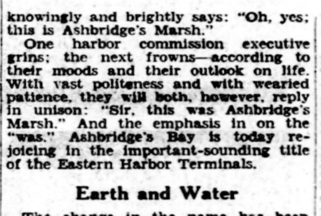


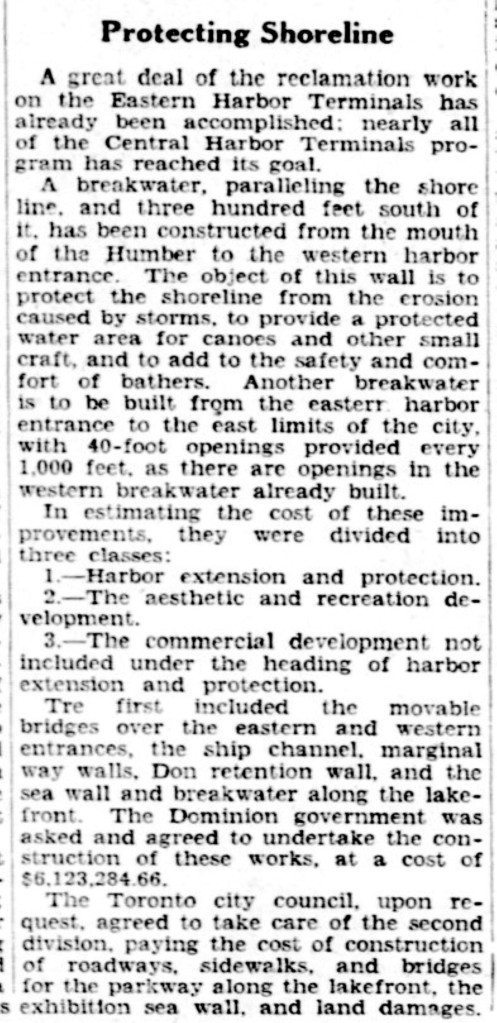


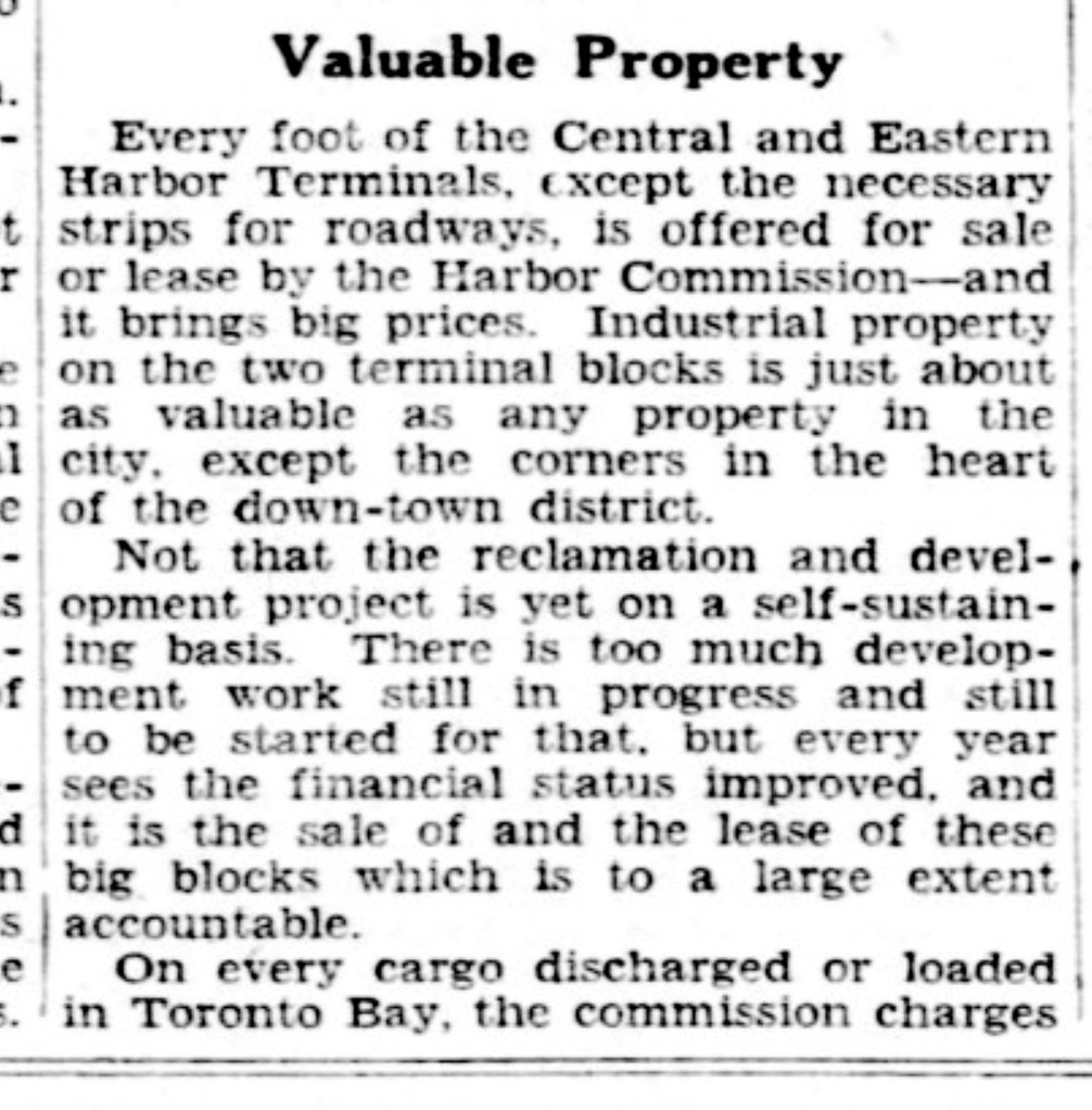


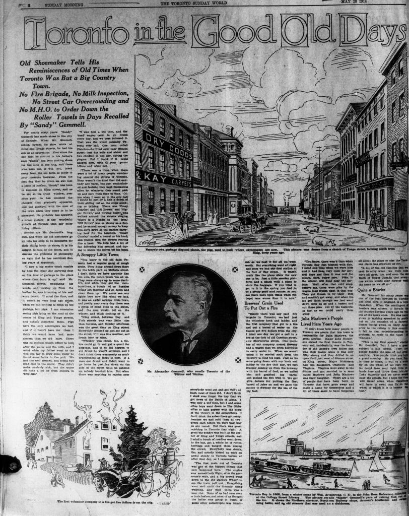


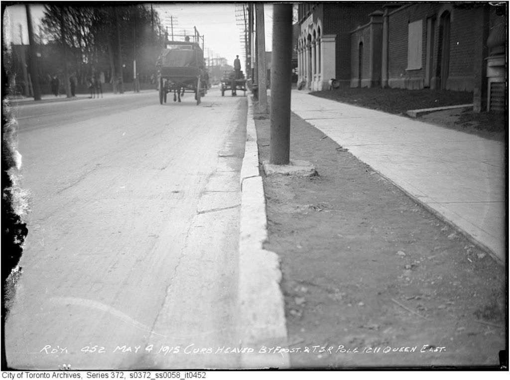


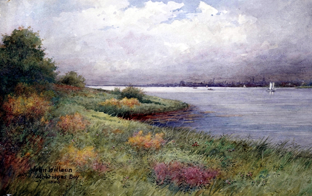


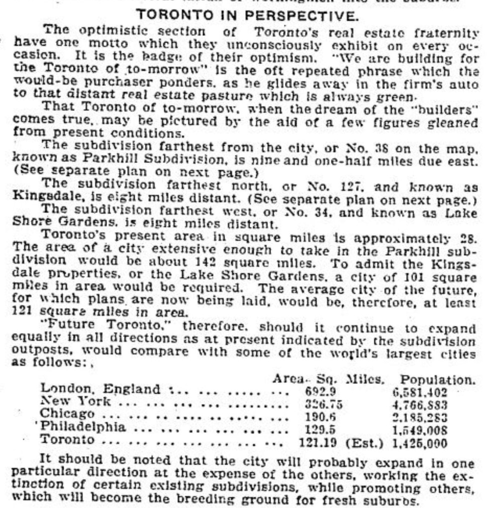


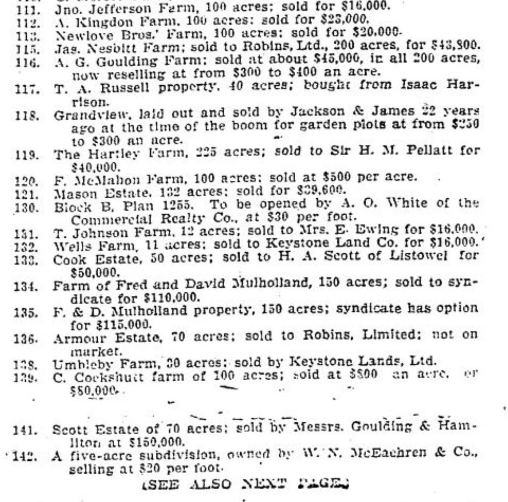


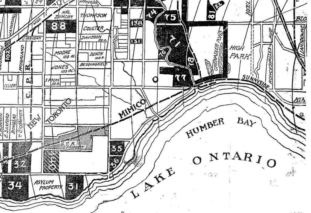


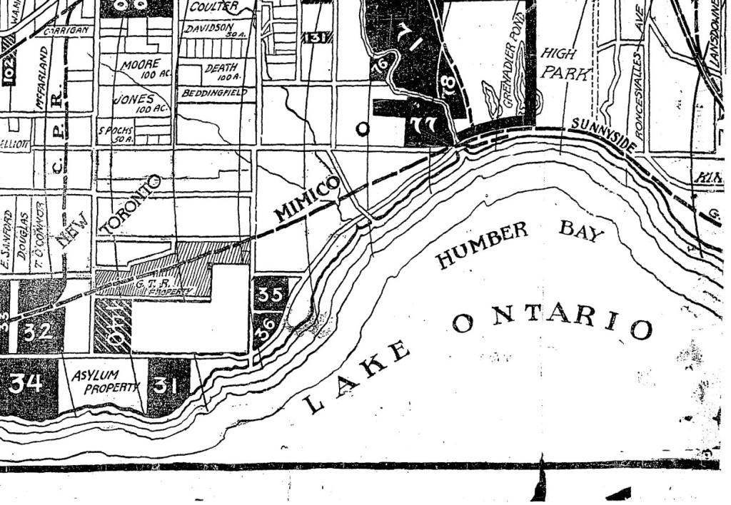
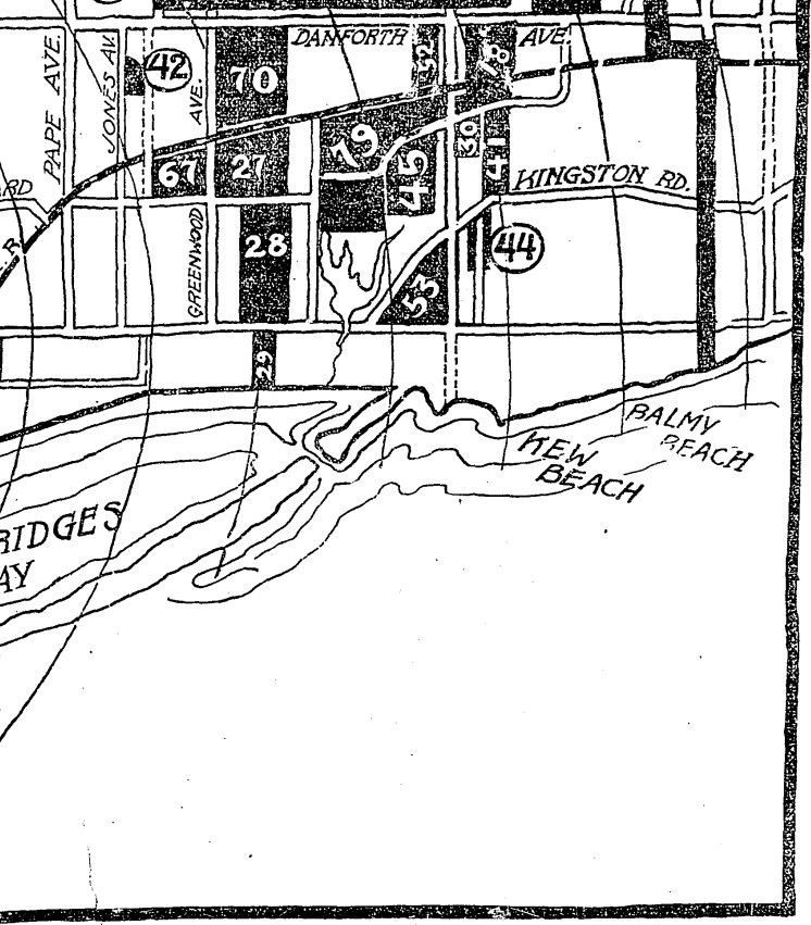


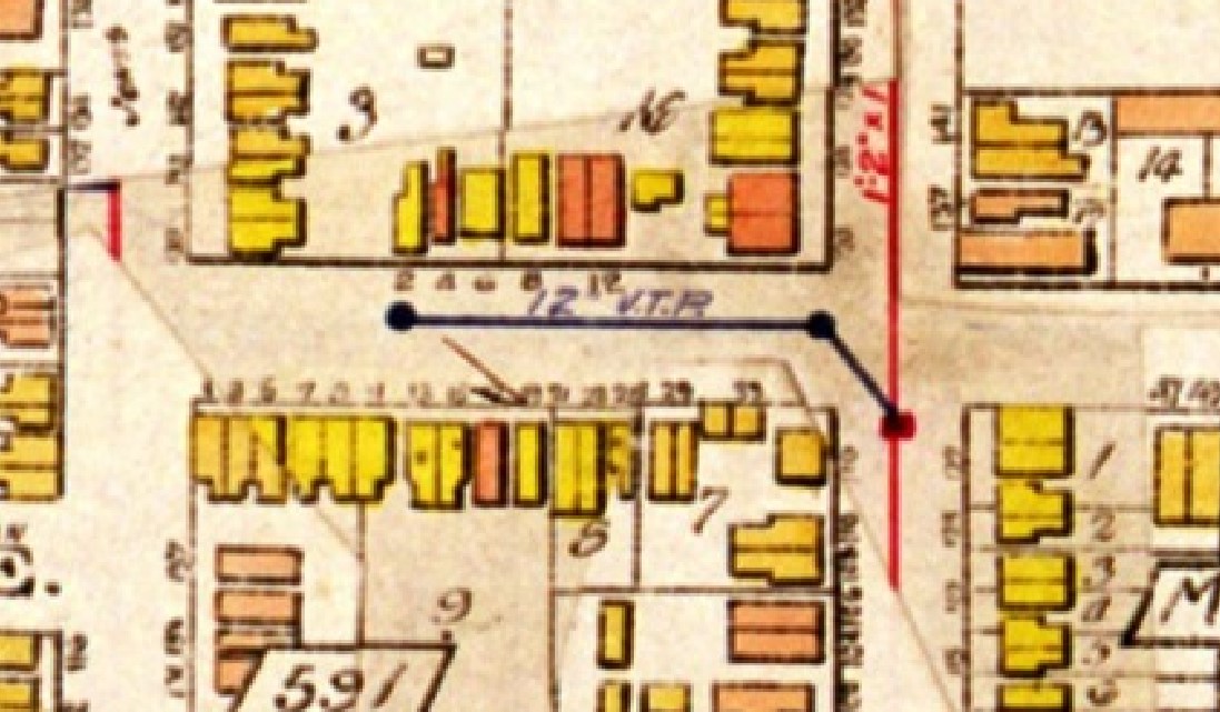


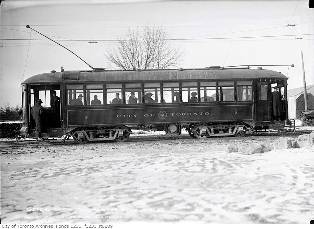


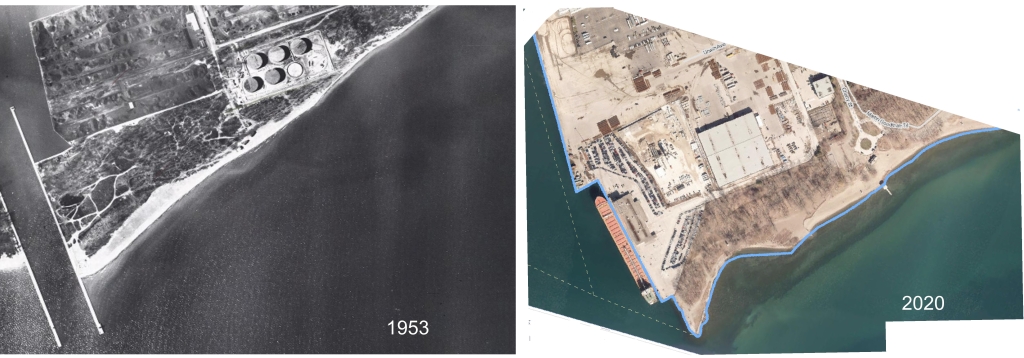


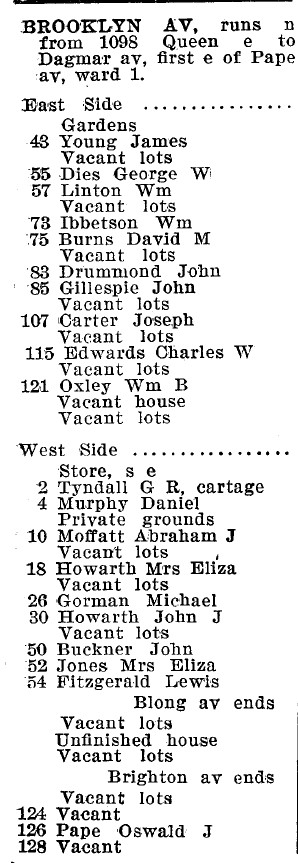


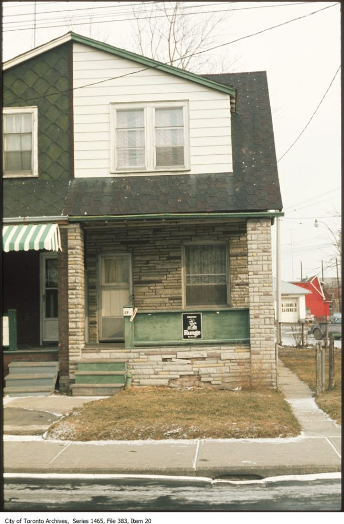


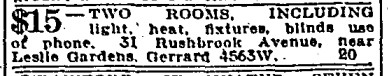


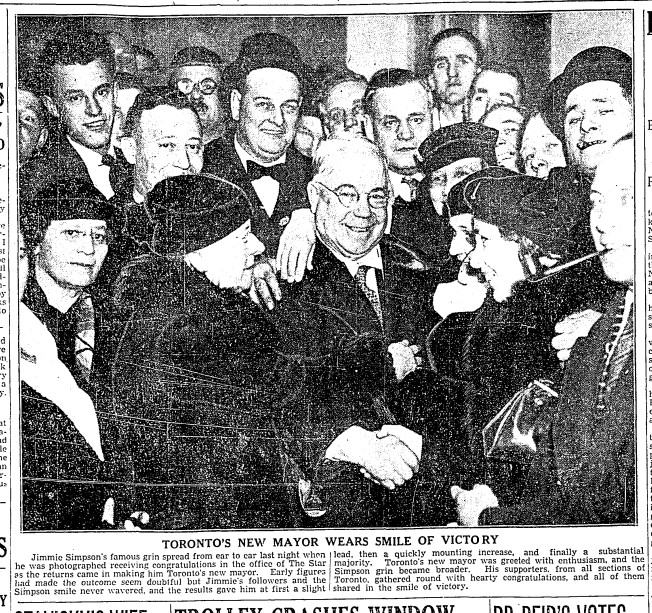


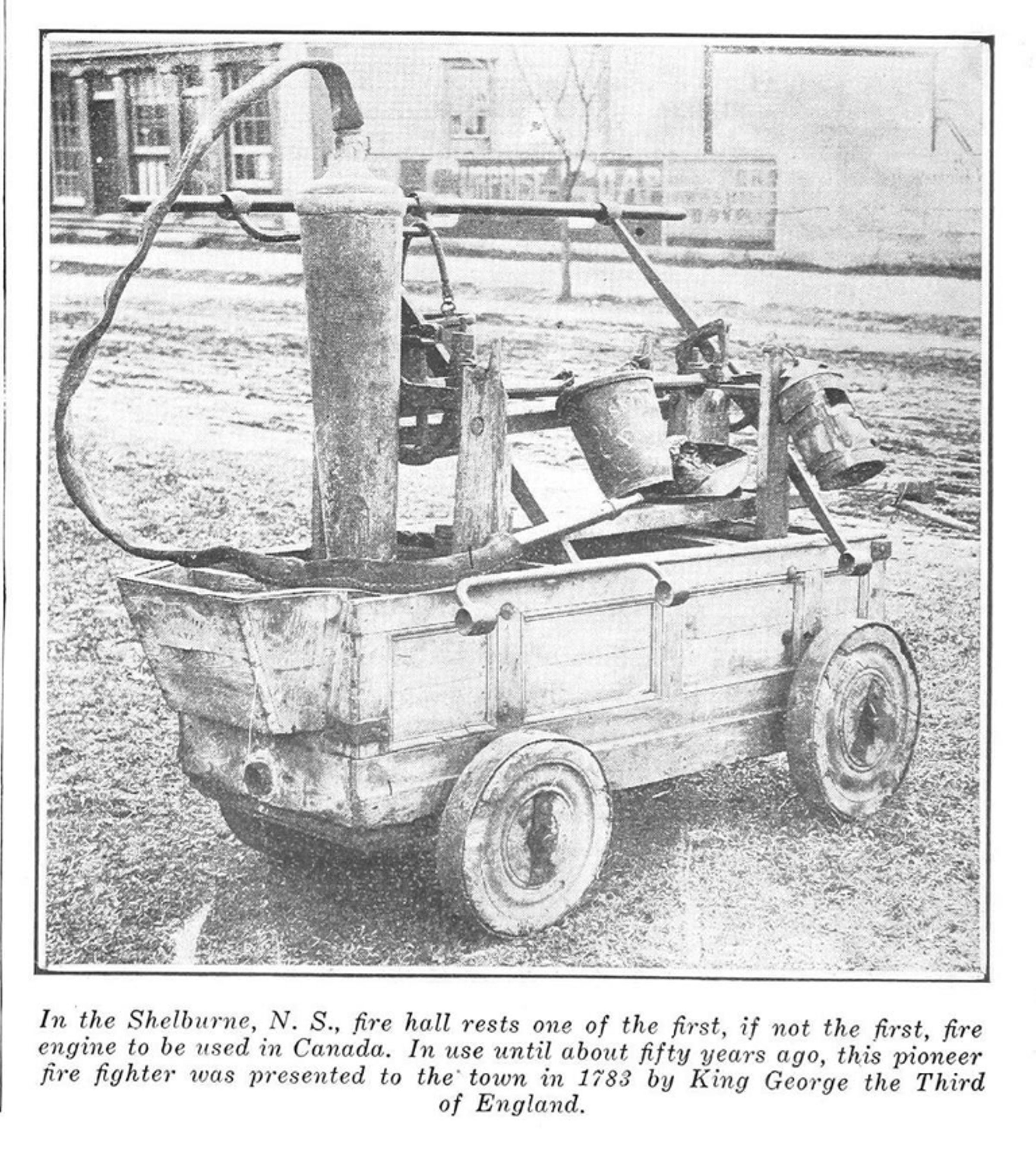


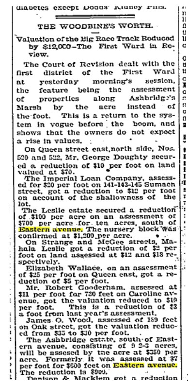


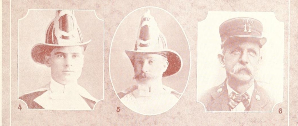


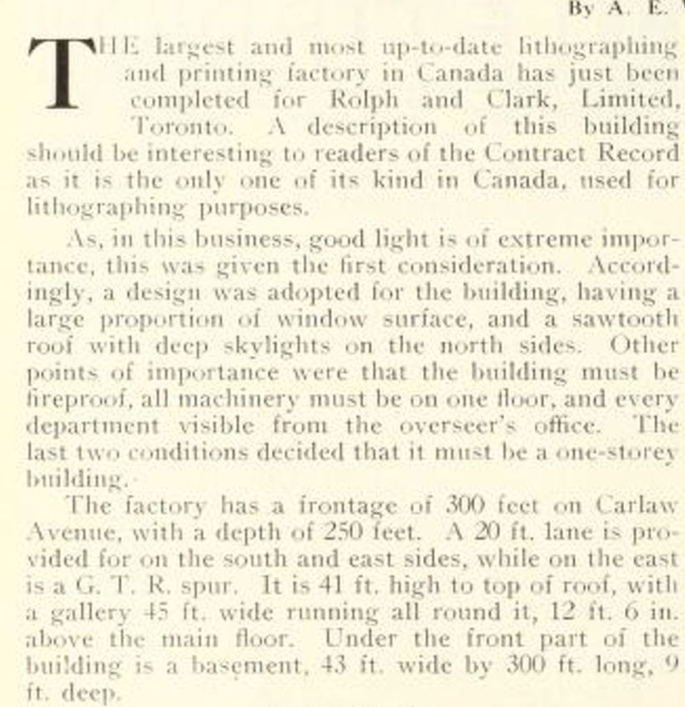


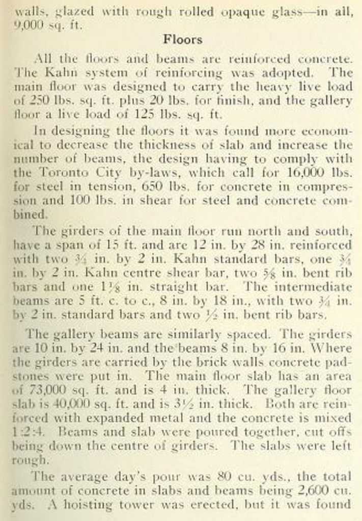


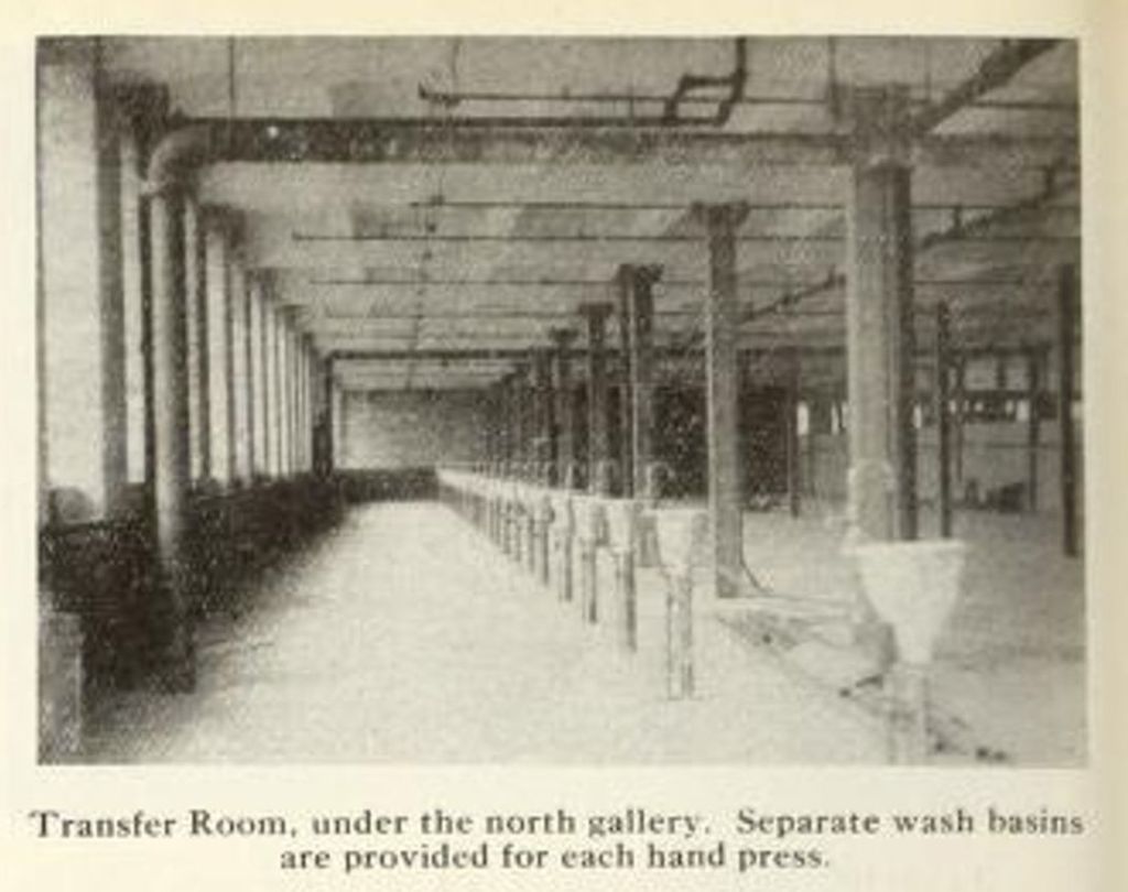


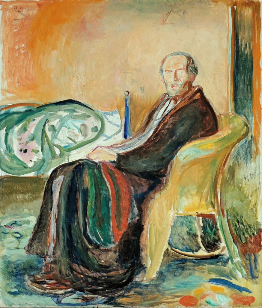


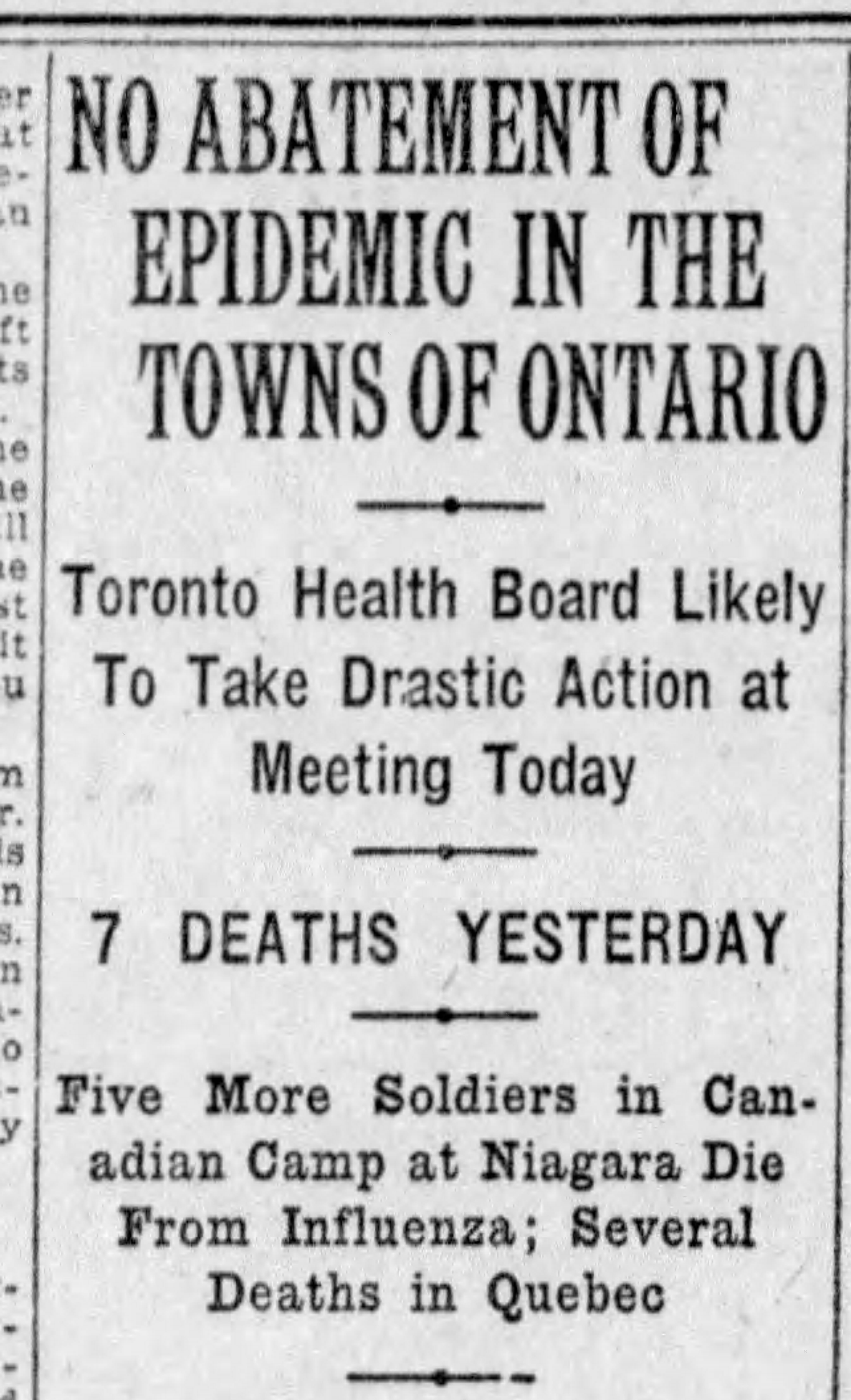


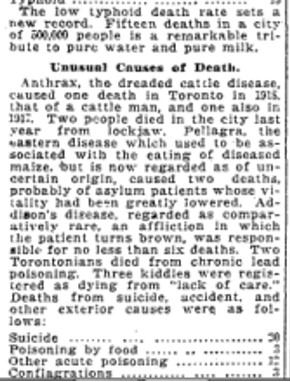


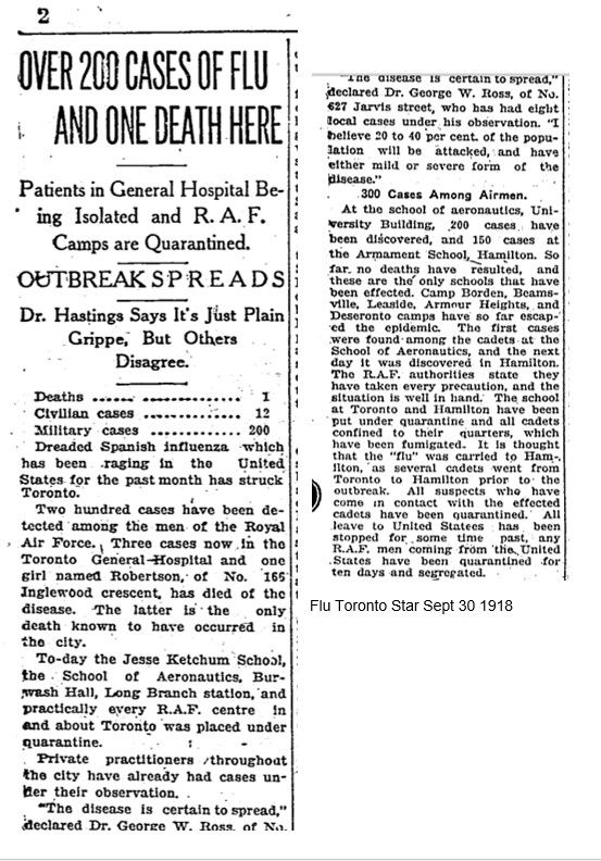
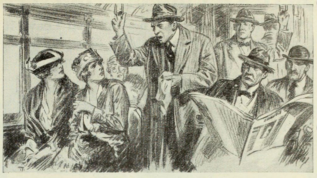
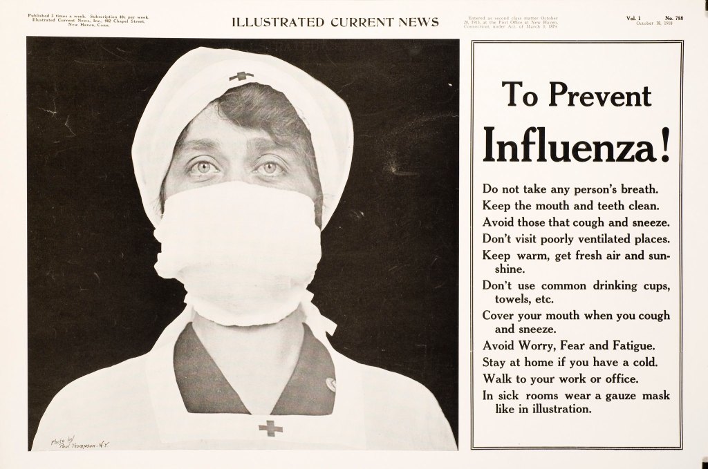


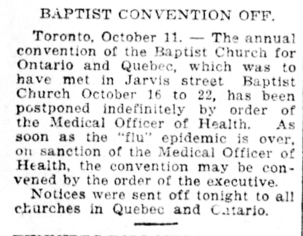


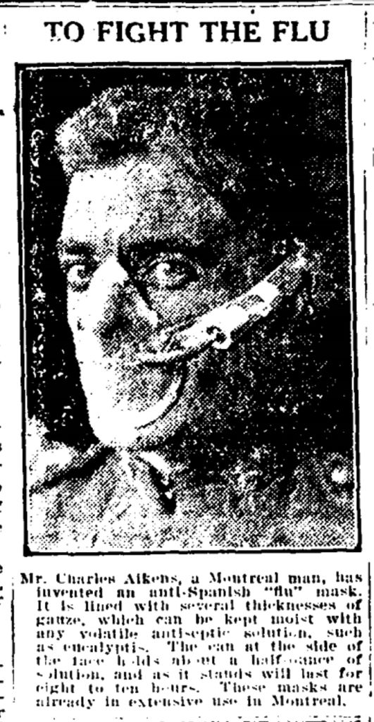


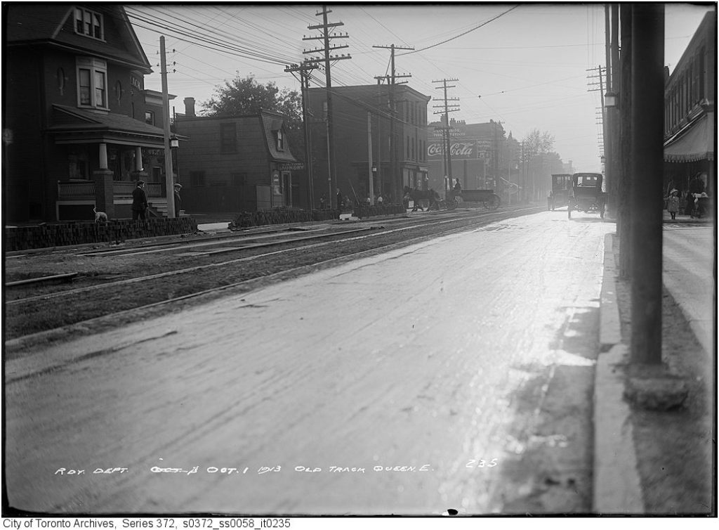


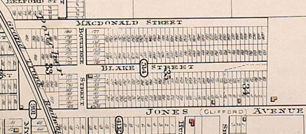


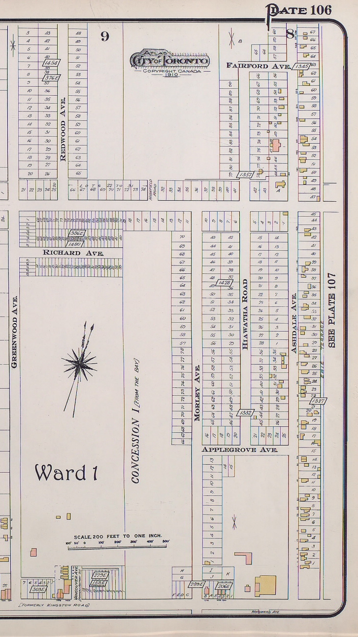
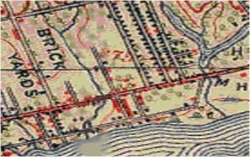


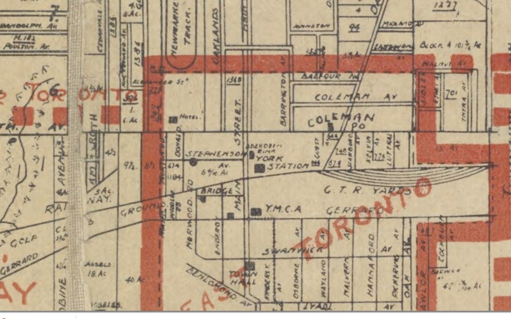


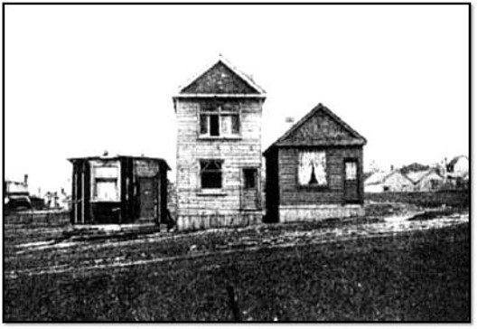


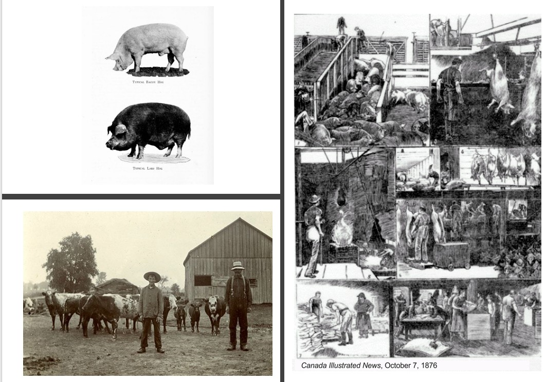


![Half-Way House, Kingston Road. - [1920?]](https://leslievillehistory.files.wordpress.com/2018/02/19200000-tarch-halfway-house-wm-james.jpg)


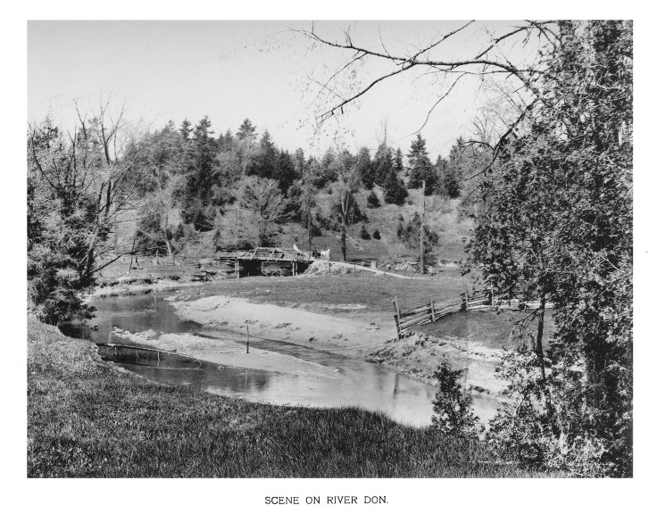
 At the point at which the Don is reached jut about Millen’s Hollow the river makes almost a half circle, opening up a wide stretch of valley, along which between the branches of the trees one catches glimpses of the running water. It is indeed a pleasant place, seated in the shade, from which to enjoy the cool breeze and pretty picture, after a sharp run.


 A DON MOUNT WIFE-BEATING CASE.


 Leslieville men had a reputation for fighting with their feet, kicking their opponents when they were down:


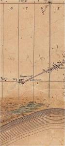


![The Canadian Contract Record [Vol. 5, no. 13 (May 3, 1894)]](https://leslievillehistory.files.wordpress.com/2016/09/the-canadian-contract-record-vol-5-no-13-may-3-1894.jpg)


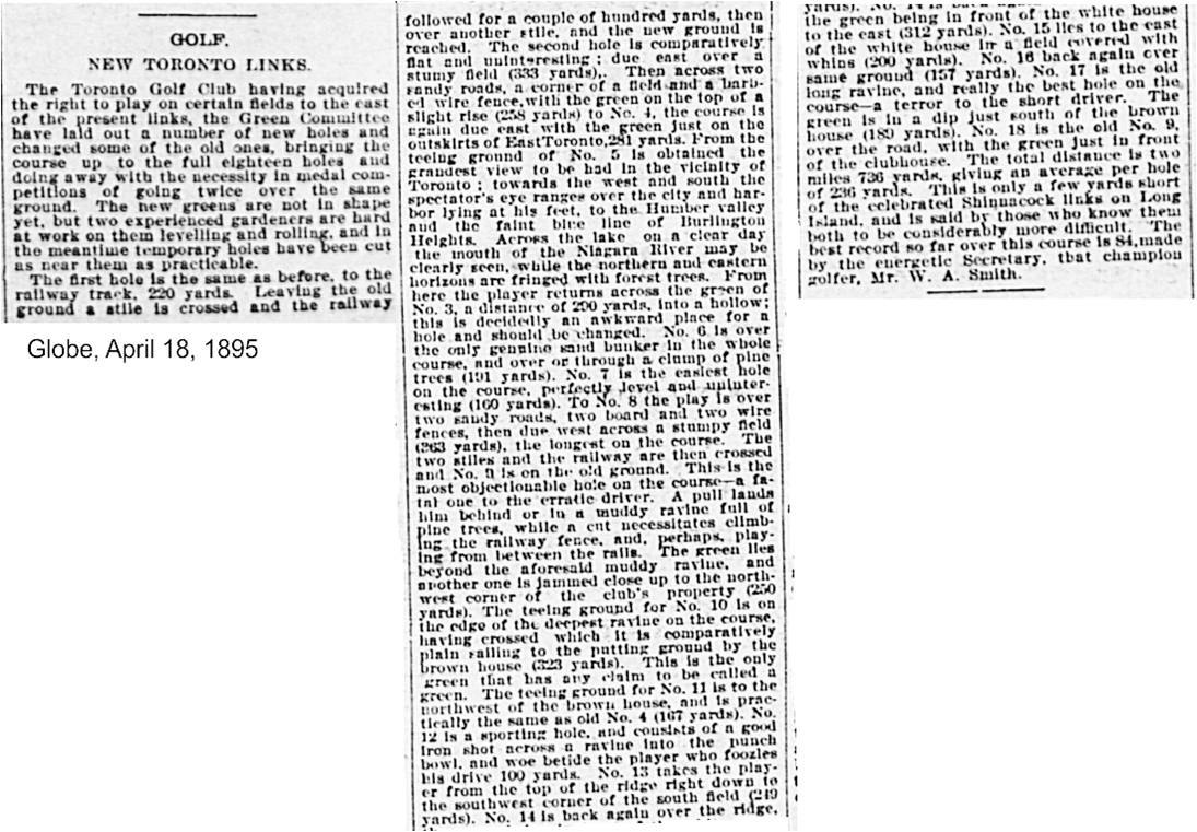


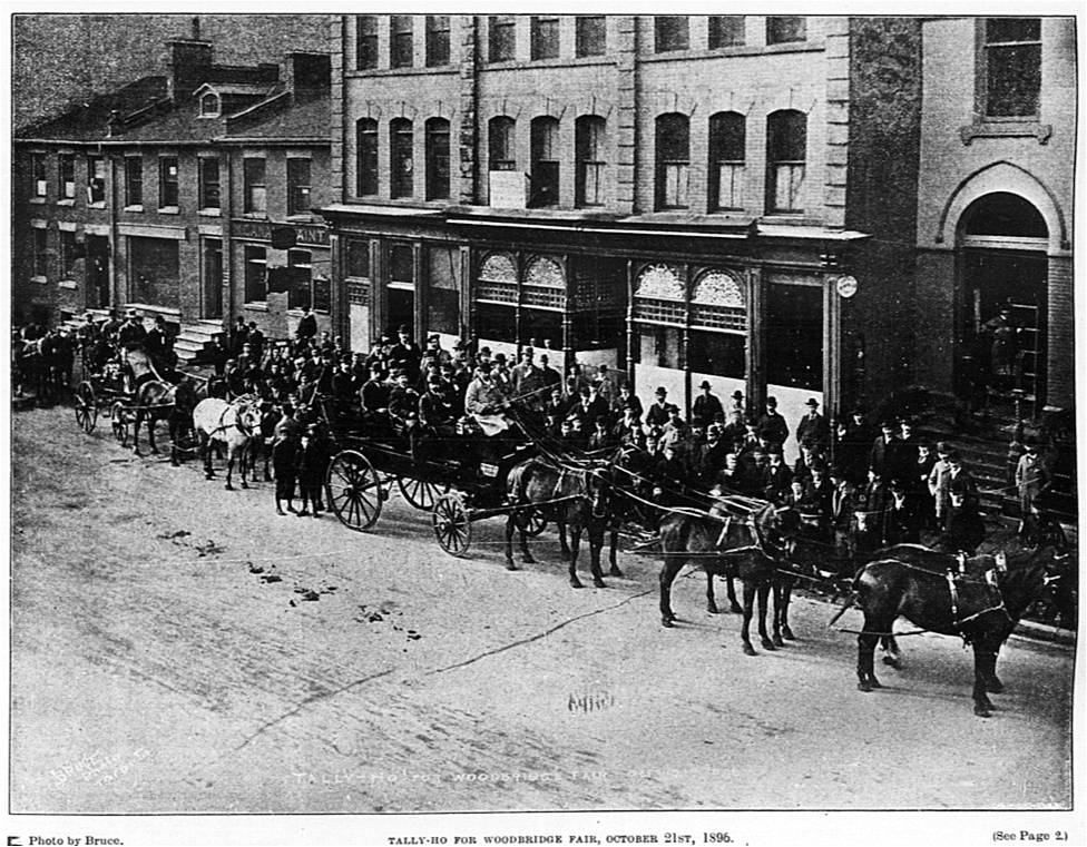
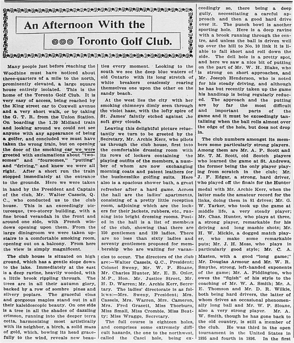


![The WEEK [Vol. 13, no. 51 (Nov. 13, 1896)]](https://leslievillehistory.files.wordpress.com/2016/09/the-week-vol-13-no-51-nov-13-1896.jpg)
![The WEEK [Vol. 13, no. 51 (Nov. 13, 1896)] 2](https://leslievillehistory.files.wordpress.com/2016/09/the-week-vol-13-no-51-nov-13-1896-2.jpg)
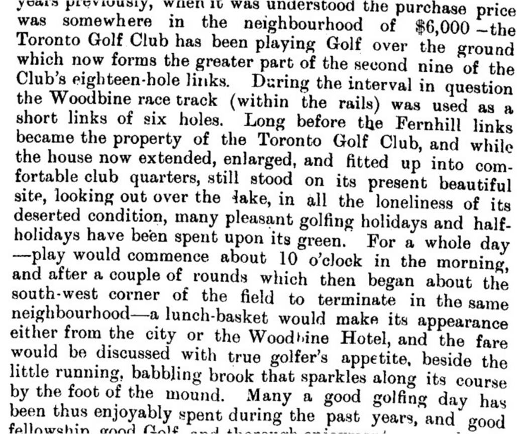
![The WEEK [Vol. 13, no. 51 (Nov. 13, 1896)] 5](https://leslievillehistory.files.wordpress.com/2016/09/the-week-vol-13-no-51-nov-13-1896-51.jpg)
![The WEEK [Vol. 13, no. 51 (Nov. 13, 1896)] 6](https://leslievillehistory.files.wordpress.com/2016/09/the-week-vol-13-no-51-nov-13-1896-6.jpg)
![The WEEK [Vol. 13, no. 51 (Nov. 13, 1896)] 7](https://leslievillehistory.files.wordpress.com/2016/09/the-week-vol-13-no-51-nov-13-1896-7.jpg)
![The WEEK [Vol. 13, no. 51 (Nov. 13, 1896)] 8](https://leslievillehistory.files.wordpress.com/2016/09/the-week-vol-13-no-51-nov-13-1896-8.jpg)