Alternative suggestions:
- Merthyr Tydfil, Merthyr Tydfil? (as text search)
Your search for images, within 10km of Merthyr Tydfil, Merthyr Tydfil, returns 9,820 images:
( Page 1 2 3 4 5 6 7 8 ... next >> ) [refine search] [quick refine]
[1 squares within 4km have no or only one photo - can you add more?]
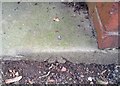 |
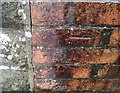
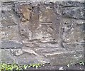
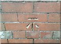
Ordnance Survey Rivet by Adrian Dust for square SO0506 Dist:0.2km Tags: [top:Historic sites and artefacts] [top:Housing, Dwellings] [type:Close Look]
This OS rivet can be found on the entrance step to Park Side House. It marks a point 220.870m above mean sea level.
|
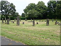 |
Gorsedd Stone Circle, Merthyr Tydfil by Eirian Evans geograph for square SO0506 Dist:0.2km Tags: [top:People, Events] [top:Public buildings and spaces] [top:Suburb, Urban fringe] [type:Geograph] [subject:stone circle]
Off Queen's Road, opposite Thomastown Park Recreation Ground.
|
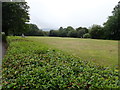 |
Thomastown Park Recreation Ground by Eirian Evans geograph for square SO0506 Dist:0.2km Tags: [top:City, Town centre] [top:Park and Public Gardens] [type:Geograph] [subject:park] |
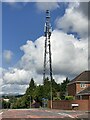 |
Communications mast by Alan Hughes geograph for square SO0506 Dist:0.2km Tags: [top:Communications] [top:Suburb, Urban fringe] [type:Geograph] |
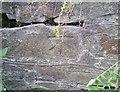 |
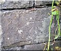
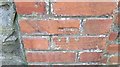
Ordnance Survey Cut Mark by Adrian Dust for square SO0506 Dist:0.2km Tags: [top:Historic sites and artefacts] [type:Close Look]
This OS cut mark can be found on the wall SE side of Queens Road. It marks a point 225.528m above mean sea level.
|
 |
Ordnance Survey Cut Mark by Adrian Dust for square SO0506 Dist:0.3km Tags: [top:Historic sites and artefacts] [top:Housing, Dwellings] [type:Close Look]
This OS cut mark can be found on the wall of No1 Edward Close. It marks a point 254.621m above mean sea level.
|
 |
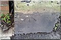
Ordnance Survey Rivet by Adrian Dust for square SO0506 Dist:0.3km Tags: [top:Historic sites and artefacts] [top:Paths] [top:Roads, Road transport]
This OS rivet can be found on the wall at the junction of path and Queens Road. It marks a point 217.670m above mean sea level.
|
 |
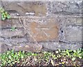
Ordnance Survey Cut Mark by Adrian Dust for square SO0506 Dist:0.3km Tags: [top:Historic sites and artefacts] [type:Close Look]
This OS cut mark can be found on the wall north side of Penyard Road. It marks a point 219.176m above mean sea level.
|
 |
Ordnance Survey Cut Mark by Adrian Dust for square SO0506 Dist:0.3km Tags: [top:Historic sites and artefacts] [type:Close Look]
This OS cut mark can be found on the wall NE side of Penyard Road. It marks a point 207.679m above mean sea level.
|
 |
Ordnance Survey Cut Mark by Adrian Dust for square SO0506 Dist:0.3km Tags: [top:Historic sites and artefacts] [type:Close Look]
This OS cut mark can be found on the wall NE side of Penyard Road. It marks a point 201.141m above mean sea level.
|
 |
Ordnance Survey Cut Mark by Adrian Dust for square SO0506 Dist:0.3km Tags: [top:Historic sites and artefacts] [type:Close Look]
This OS cut mark can be found on the wall junction east side of the road. It marks a point 233.260m above mean sea level.
|
 |
Ordnance Survey Cut Mark by Adrian Dust for square SO0506 Dist:0.4km Tags: [top:Historic sites and artefacts] [type:Close Look]
This OS cut mark can be found on the wall NE side of Penyard Road. It marks a point 193.661m above mean sea level.
|
 |
Ordnance Survey Cut Mark by Adrian Dust for square SO0506 Dist:0.4km Tags: [top:Historic sites and artefacts] [top:Paths] [type:Close Look]
This OS cut mark can be found on the wall north side of the path. It marks a point 209.285m above mean sea level.
|
 |
Ordnance Survey Cut Mark by Adrian Dust for square SO0506 Dist:0.4km Tags: [top:Historic sites and artefacts] [top:Housing, Dwellings] [type:Close Look]
This OS cut mark can be found on the wall between Nos2 & 4, The Parade. It marks a point 222.806m above mean sea level.
|
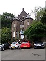 |
Merthyr Tydfil Synagogue by Eirian Evans geograph for square SO0506 Dist:0.4km Tags: [top:City, Town centre] [top:Derelict, Disused] [top:Historic sites and artefacts] [top:Religious sites] [type:Geograph] [subject:synagogue]
Merthyr Tydfil had the biggest Jewish community in Wales and at its height there were 400 Jews in the town. This became a very influential and prosperous Jewish... (more)
|
Search took 0.01 secs, ( Page 1 2 3 4 5 6 7 8 ... next >> ) [refine search]
View/Download: KML geo RSS GPX Try opening in Browser function (Experimental, may not work!)Expand Word Statistics
Found these results useful? Please Donate
|