Grid reference SH579722
near to Bangor, Gwynedd, Wales
Coverage
We have 334 images in grid square SH5772
Contribute
Explore centiquare SH579722
Explore gridsquare SH5772
Surrounding area
Maps
 Map © Crown Copyright")
TIP: Click the map for more Large scale mapping
Tip: Click the map to open the coverage map
A sample of 12 photos from 334 for SH5772 - View this square in the Browser >>>
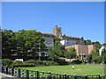 |
University College of North Wales, Bangor
Top Col, the main College building on the hill overlooking Bangor, with the Students' Union in the trees on the left and Theatr Gwynedd on the right.
|
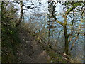 |
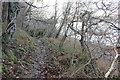
Wales Coast Path along the Menai Strait
by Mat Fascione
|
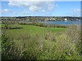 |
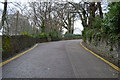
Woodland and grazing, Upper Bangor
by JThomas
Looking towards the Menai Strait from The Look Out.
|
 |
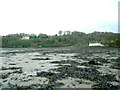
Nantporth Nature Reserve
by Jeff Buck
A very muddy Wales Coast Path passing through Nantporth Nature Reserve at Upper Bangor. The Menai Strait can be seen on the right. North Wales Wildlife Trust Link |
 |
Shoreline, Bangor
by Eirian Evans
Looking east along the shoreline, near the old outdoor baths. Garth Pier is in the distance.
|
 |
Glanrafon Hill / Allt Glanrafon
by N Chadwick
|
 |
Bangor University
by Iain Lees
Looking to Great Orme.
|
 |
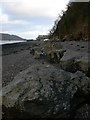
Derwen Deg and Gorad y Gyt at low tide
by olly knowles
|
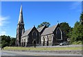 |
Our Lady and St. James' Church, Bangor
The former Anglican St. James' Church which became Our Lady & St. James' Catholic Church in 1996. Grade II listed. Cadw Building ID: 4083 Built 1866 by Kennedy and Rogers, architects of Bangor; Kennedy was diocesan... (more)
|
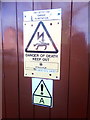 |
Signs at Dargie substation on Temple Road, Bangor
by Meirion
|
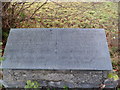 |
Wartski Fields memorial, Bangor
by Meirion
This pair of stone tablets on a plinth are to be found hidden behind the fence on Holyhead Road in Bangor. There is a Welsh and an English tablet. The tablets read: WARTSKI FIELDS Donated to the City of Bangor by Winifred Marie... (more)
|
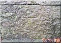 |
Ordnance Survey Cut Mark
by Adrian Dust
This OS cut mark can be found on the wall SW side of the road. It marks a point 56.514m above mean sea level.
|
Explore more images in this square: | View Filtering options | View all 334 images page by page >>> |
|