Approximate Location Map
Large Map »
Latitude: 53.2374 / 53°14'14"N
Longitude: -4.1229 / 4°7'22"W
OS Eastings: 258415
OS Northings: 373254
OS Grid: SH584732
Mapcode National: GBR 5Q.00YV
Mapcode Global: WH541.MWXJ
Plus Code: 9C5Q6VPG+XR
Entry Name: Bangor Pier
Listing Date: 31 October 1974
Last Amended: 2 August 1988
Grade: II*
Source: Cadw
Source ID: 3987
Building Class: Maritime
Also known as: Pier y Garth
ID on this website: 300003987
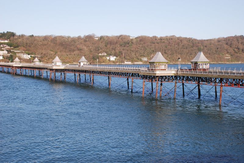
Location: Stretching over ¼ mile across the Menai Straits.
County: Gwynedd
Community: Bangor
Community: Bangor
Built-Up Area: Bangor
Traditional County: Caernarfonshire
Tagged with: Pier
Built 1896 by Mr J J Webster of London, contractors Mr Alfred Thorne of London; cost £17,000. It is considered to be the best in Britain of the older type of pier without a large pavilion at the landward end. Damaged by a ship in 1914; closed in 1971 and currently undergoing restoration (Autumn 1987).
1550ft long; the longest surviving in Wales. Largely original steel girders and cast iron columns carrying an extensively rebuilt 24ft wide timber planked deck, kiosks, and pavilions. The pier is entered through ornate wrought iron gates enriched with fleurons and barley twist uprights; square openwork gate piers carrying lanterns. These are flanked by octagonal kiosks with onion domed roofs and Indian style trefoil headed openings; beyond these are similar smaller gates. Cast iron lampstandards and full length seating to each side of deck. The pier projects at various intervals beyond with polygonal timber kiosks with mostly tent-like roofs. Splayed out at NW end containing 14 sided timber pavilion with 2-stage pyramidal roof. The iron staircase at the end with 6 levels of platforms led to the former floating pontoon.
External links are from the relevant listing authority and, where applicable, Wikidata. Wikidata IDs may be related buildings as well as this specific building. If you want to add or update a link, you will need to do so by editing the Wikidata entry.


Other nearby listed buildings
