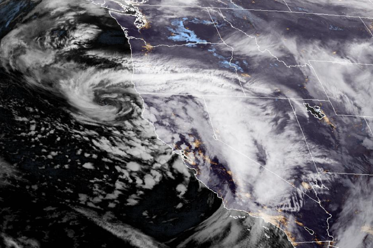
As the latest storm to batter California begins to let off on Tuesday, leaving severe flooding and destruction in its wake, residents will be bracing for another "enormous" cyclone to slam into the Pacific coast on Wednesday, forecasters have predicted.
According to the latest short-range forecast from the National Weather Service (NWS), this "rapidly intensifying" weather system will impact areas from northern California and up the coast into the Pacific Northwest.
It anticipates that the total precipitation over the coming days will range between 3 and 7 inches. The latest storm to hit the state on Monday brought on average between 5 and 10 inches of rain across coastal regions, it said earlier, with rain levels as high as 15.5 inches recorded at certain locations.
Wednesday's cyclone will be the latest in a series of high-intensity storms to hammer California since New Year's Eve, leading to thousands of homes without power, thousands of families evacuated due to flooding and at least 14 deaths.
The series of storms prompted California Governor Gavin Newsom on Sunday to ask the White House to declare an emergency in order to support response efforts. President Joe Biden approved this declaration late Sunday night, the White House said.
"We are in the middle of a deadly barrage of winter storms—and California is using every resource at its disposal to protect lives and limit damage," Newsom said in a statement. "We are taking the threat from these storms seriously, and want to make sure that Californians stay vigilant as more storms head our way."
The NWS said on Tuesday that nearly all of California has seen rainfall in the past few weeks between 400 and 600 percent of average totals.
"This has resulted in nearly saturated soils and increasingly high river levels," it said. "Today's heavy rain will further exacerbate ongoing flooding while prolonging the risk of flash flooding and mudslides especially across recent burn scar regions."
NWS meteorologists anticipate heavy rain to resume across much of California through Tuesday and into the night, with "several more feet of snow" possible along the Sierra Nevada. It expects the latest weather front to be "packing some thunderstorms" as well.
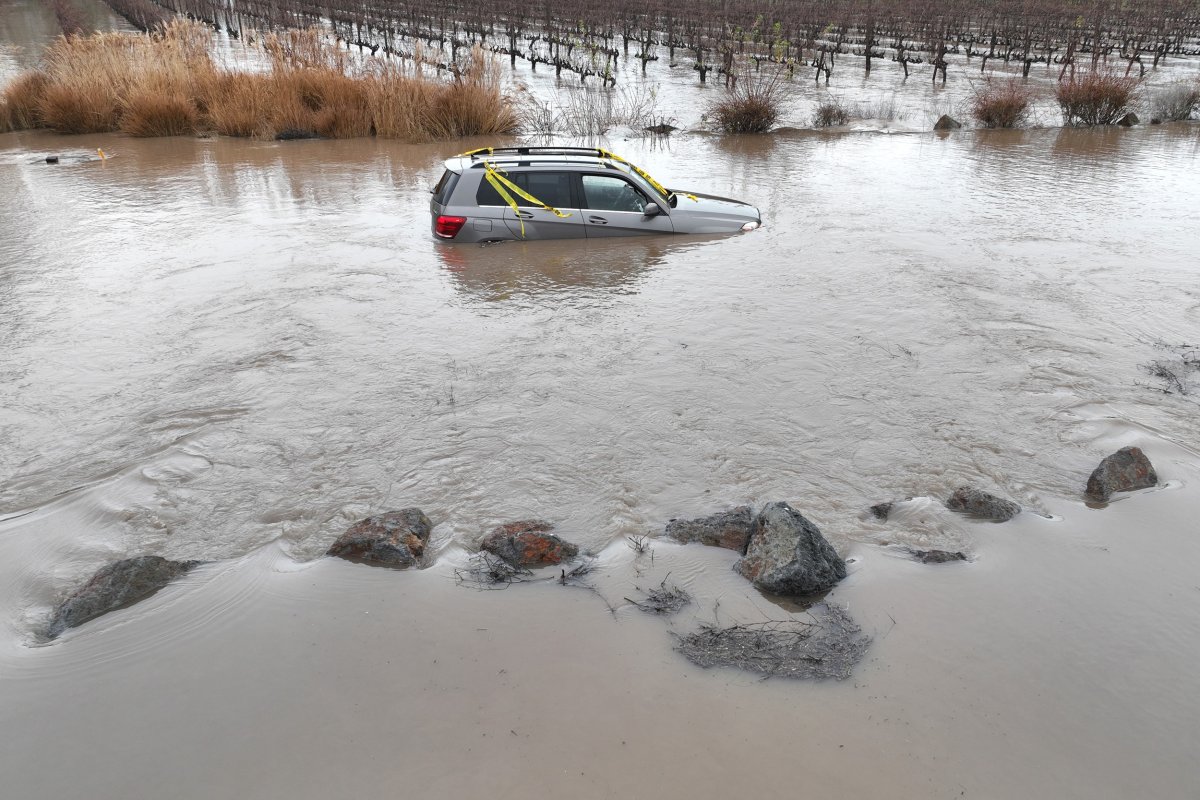
Vast swathes of California remain under flood warnings—including Los Angeles, San Luis Obispo, Santa Barbara and Ventura counties—after Monday's rainfall. Some 10,000 people in Santa Barbara County have been told to evacuate due to flood risk, and a further 32,000 people in Santa Cruz County, according to the Associated Press.
As of 9:51 a.m. ET, more than 230,000 homes across California were without power, according to PowerOutage, with power lines downed by flood waters and nearby falling trees. Two flood-related deaths on Monday were due to falling trees, state officials said.
Footage being posted on social media shows flooded roads and highways, rock falls in Fresno and emergency responders mounting rescue efforts for those trapped in vehicles by rapidly flowing floodwater.
As a sizeable portion of California still remains in extreme drought—with major reservoir storage in the state still below average—it is now suffering from what Daniel Swain, a climate scientist at the University of California, calls "hydroclimate whiplash": swinging from extremely hot, dry conditions to extremely wet.
The drought conditions that left masses of dead trees and burn scars, which can become channels for floodwater, then create hazards during stormy conditions. And the two weather extremes are caused by climate change, which makes the north and southward fluctuations in the jet stream more violent, Mark Maslin, professor of earth system sciences at University College London and a climate author, explained.
"What California has at the moment is it has lots of moist air being brought across the Pacific by the Jetstream. It's then being hit by a massive storm coming down from the Arctic, which has huge amounts of cold air, and as it hits the California warm air, it's causing massive amounts of rain," he told Newsweek. "And so you have these two sources of water: one coming from the Arctic cold air, which is being warmed up and therefore the warm air is then precipitating rainfall, and you have lots of rain coming from the Pacific."
"What's happening here—and it's partly weather, partly climate change—is rain is falling more heavily because there is more moisture in the atmosphere, because the atmosphere is warmer," Maslin added.
Tuesday's storm will push eastward into western U.S. overnight, and will be "re-energized" as it pulls cold air from the north and warm air from the south, the NWS said.
Uncommon Knowledge
Newsweek is committed to challenging conventional wisdom and finding connections in the search for common ground.
Newsweek is committed to challenging conventional wisdom and finding connections in the search for common ground.
About the writer
Aleks Phillips is a Newsweek U.S. News Reporter based in London. His focus is on U.S. politics and the environment. ... Read more
To read how Newsweek uses AI as a newsroom tool, Click here.