Orienteering is a group of sports that involve using a map and compass to navigate from point to point in diverse and usually unfamiliar terrain whilst moving at speed. Participants are given a topographical map, usually a specially prepared orienteering map, which they use to find control points.[1] Originally a training exercise in land navigation for military officers, orienteering has developed many variations. Among these, the oldest and the most popular is foot orienteering. For the purposes of this article, foot orienteering serves as a point of departure for discussion of all other variations, but almost any sport that involves racing against a clock and requires navigation with a map is a type of orienteering.


Orienteering is included in the programs of world sporting events including the World Games[2] (see Orienteering at the World Games) and World Police and Fire Games.[3]
History edit
The history of orienteering begins in the late 19th century in Sweden. The actual term "orientering" (the original Swedish name for orienteering, lit. "orientation") was first used in 1886 at the Swedish Military Academy Karlberg and meant the crossing of unknown land with the aid of a map and a compass.[4] In Sweden, orienteering grew from military training in land navigation into a competitive sport for military officers, then for civilians. The name is derived from a word root meaning to find the direction or location. The first civilian orienteering competition open to the public was held in Norway in 1897, when Norway was still a part of the Swedish union.[4]
From the beginning, locations selected for orienteering have been chosen in part for their beauty, natural or man-made. For the first public orienteering competition in Sweden, in 1901, control points included two historic churches, Spånga kyrka and Bromma kyrka (a round church).[5]

With the invention of inexpensive yet reliable compasses, the sport gained popularity during the 1930s. By 1934, over a quarter million Swedes were participants, and orienteering had spread to Finland, Switzerland, the Soviet Union, and Hungary. Following World War II, orienteering spread throughout Europe and to Asia, North America and Oceania. In Sweden in 1959, an international orienteering conference was held. Representatives from 12 countries (Austria, Bulgaria, Czechoslovakia, Denmark, Finland, East and West Germany, Hungary, Norway, Sweden, Switzerland, Yugoslavia) participated.[4] In 1961, orienteering organizations representing 10 European nations founded the International Orienteering Federation (IOF). Since then, IOF has supported the founding of many national orienteering federations. By 2010, 71 national orienteering federations were member societies of the International Orienteering Federation.[6] These federations enabled the development of national and world championships. World championships were held every two years until 2003, then every year.[7]
Throughout this time, orienteering has remained most popular in Scandinavia. There, the two oldest recurring orienteering meets have been held since the 1940s (Jukola relay and Tiomila), and the single largest orienteering meet has been held every year since 1965 and attracts around 15,000 competitors (O-Ringen).[8]
Typically, orienteering is run in wild terrain. In its Scandinavian origins, this typically meant in the forest, but orienteering in open fell, heathland, moorland and other mixed terrain is also common. Orienteering in towns has been common for many years. Street-O has typically been a low-key affair; score events, often at night, normally as informal training events. The Venice street-O is notable for attracting a large international participation. With Park World Tour[9] races and other (e.g. World championships) elite sprint races often being held in urban areas, and the development of a map specification for urban areas (ISSOM), from the mid-2000s, Street-O has been rebranded as urban orienteering, and has taken itself rather more seriously, with full colour maps and electronic punching, and may now be regarded as a serious competition with inclusion in national ranking lists.[10] Such urban races are often much longer than the sprint distance.
Variations edit
Orienteering sports combine significant navigation with a specific method of travel. Because the method of travel determines the needed equipment and tactics, each sport requires specific rules for competition and guidelines for orienteering event logistics and course design.
International Orienteering Federation, the governing body of the sport, currently sanctions the following four disciplines as official disciplines in the sport of orienteering:
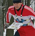
- Foot orienteering (FootO)
- Mountain bike orienteering (MTBO)
- Ski orienteering (SkiO)
- Trail orienteering (TrailO)
Moreover, International Amateur Radio Union (IARU) sanctions the following orienteering sport:
- Amateur radio direction finding (Radio orienteering or ARDF) [including variants Fox Oring and Radio Orienteering in a Compact Area (ROCA)]
Other orienteering disciplines include, but are not limited to:
- Biathlon orienteering
- Canoe orienteering
- Car orienteering
- Mountain marathoning
- Mounted orienteering
- Rogaining
- Sport Labyrinth – micro orienteering
Adventure racing is a combination of two or more disciplines, and usually includes orienteering as part of the race.
Governing bodies edit
International edit
At international level, the International Orienteering Federation (IOF)[11] defines rules and guidelines[12] which govern four orienteering sports: foot orienteering, mountain bike orienteering, ski orienteering, and trail orienteering.[13] It is based in Sweden[14] and it claims on its website to aim to "spread the sport of orienteering, to promote its development and to create and maintain an attractive world event programme."[15] Since 1977 the IOF has been recognised by the IOC.[16]
National edit
There are governing bodies for most of the individual nations that are represented in the sport of orienteering. These national bodies are the rule-making body for that nation. For example, the British Orienteering Federation is the national governing body for the United Kingdom. The federation was founded in 1967 and it is made up of 13 constituent associations.[17] For the United States, the national governing body is Orienteering USA.
Regional edit
Most nations have some form of regional governing bodies. These are not rule-making bodies but are there to assist in coordinating clubs within that region, e.g., they may allocate dates so that clubs do not clash with their events.
Local edit
Clubs are usually formed at a local level and affiliated to their national governing body. It is clubs who put on events usually open to all-comers. Clubs may also put on practice, training, and social events. Open clubs are open to anyone and there is usually no restriction on joining them. Closed clubs restrict their membership to specific groups. For example, BAOC (British Army Orienteering Club)[18] has restrictions on who may join, principally British Army personnel.
Related sports edit
- The International Rogaining Federation governs rogaining.[19]
- Separate organizations govern competitive mounted orienteering in the United States and Europe (and the two sports are dissimilar).
- The International Amateur Radio Union governs amateur radio direction finding.[20]
Competition and results edit
Basics edit

The competition, or race, is intended to test the navigational skill, concentration, and running ability of the competitors. High levels of fitness and running speed are required to compete successfully at an international or elite level. To ensure fairness between competitors the map is not usually provided until the start, and starts are normally staggered with competitors starting at not less than one-minute intervals.[21]
The objective on each leg is to follow the fastest route between controls. The fastest is not always the shortest route, and can depend heavily on route choice.[22]
Map edit

Orienteering competitions use specially prepared orienteering maps. They are topographic maps although much more detailed than general-purpose maps. The ISOM map scales are 1:15,000, 1:10,000, or 1:7,500, with grids aligned to magnetic north. Map symbols are standardized by the IOF,[23] and designed to be readable by any competitor regardless of background or native tongue.
Courses edit

Orienteering events offer a range of courses, of varying physical and technical difficulty, to meet the needs of competitors. The orienteering course is marked in purple or red on a map.[24] A triangle is used to indicate the start and a double circle indicates the finish. Circles are used to show the control points.[25]
edit
At international, national, and the larger events, courses are classified by age, e.g., M35 for men 35 years of age and older. Classes requiring similar distances and difficulties are usually combined into a smaller number of courses, e.g., M60 will normally share a course with W50, and often with M65 and W55. The results are normally arranged by class.[26]
Ability-based courses edit
In the smaller events courses are provided by ability. The United States[25][27] and the United Kingdom use colour coding to define the difficulty of the courses. Short, easy courses are provided for beginners and younger competitors, with technically and physically demanding courses being provided for experienced orienteers. Ranging from easy and short to long and technical, there are; White, Yellow, Orange, Light Green, Green, Blue and Brown.[28]
Permanent courses and other events edit
Some orienteering clubs have set up permanent courses, which can be used for personal, or club, training. Non-standard permanent markers are used as control kites, and maps of the courses are usually available publicly for a fee.[29] The courses are usually set up in public areas and there may be some restrictions on access, e.g., daylight hours only. Clubs also organise informal events for practice and training.[30]
Controls and control description sheet edit

Control points are placed on features on the map that can be clearly identified on the ground. Control points are marked in the terrain by white and orange "flags".
Competitors receive a "control description sheet" or "clue sheet" which gives a precise description of the feature and the location of the kite, e.g., boulder, 5m, north side. For experienced orienteers the descriptions use symbols (pictorial), in accordance with the IOF Control descriptions.[31]
Control card and punching edit

Each competitor is required to carry an electronic or paper control card, and to present it at the Start and hand it in at the Finish. The control card is marked by some means at each control point to show that the competitor has completed the course correctly. Most events now use electronic punching, although cards and needle punches are still widely used.[32]
Results edit
The winner is normally the competitor with the fastest time, but other scoring systems can be used, e.g., score events and Trail-O. Most events produce provisional results 'on the day', with draft results on the Internet that night; the final results being confirmed a few days later. With electronic punching[33] the results can include split times for competitors. These show the times between controls and aggregate times to each control. With suitable computer software these times can be displayed in a graphical form (Progressograph).[34]
Safety edit
Each competitor is responsible for his or her own safety. There are no rules, but there are guidelines, which should be followed. The basic safety check was the stub check. The competitor hands in his stub at the start and his control card at the finish. Event officials match the two and any unmatched stubs represent a missing competitor. This has been superseded with electronic punching in that event officials can now request a ‘still to finish’ report listing all those competitors who punched at the start but have not yet downloaded their electronic card. All competitors must report to the finish whether they have completed the course or not.[21][25]
Personal clothing edit
IOF rule 21.1 is that the specification for clothing is delegated to the national organising body, and no specific clothing is required.[35] Unique among English speaking countries, Ireland and the UK require legs to be covered. Rule 7.1.1 requires full body cover: the torso and legs must be covered, [36] while organizer may allow shorts (e.g., in park or street orienteering). In the United States, rule A.34.1 states that competitors are free to choose clothing that they are most comfortable in (full leg cover is not required), unless specifically stated in the meet announcement. In Australia, under the 2021 rules, 2.1.21, the choice of clothing is also left up to the competitor, and full leg cover is not required. [37] In Canada, no specific clothing is required, but participants are encouraged to wear clothing suitable for the weather, and hiking or running shoes. Similarly in New Zealand, there are no rules in force limiting orienteers to running only in full leg cover.
The early competitors used standard athletic clothing, i.e., shorts and an athletic vest, which provided little protection for racing through undergrowth. Purpose-made lightweight nylon full-body suits were later adopted. The early O-suits were made in muted colours but modern suits are generally multi-coloured. Clubs often organise the bulk purchase of clothing, which are then made in the club colours with the club's name prominently displayed. Some competitors prefer lycra tights or leggings. Gaiters are also often worn. Lightweight studded (and often cleated) orienteering shoes are commonly used.
Personal equipment edit

The basic equipment required for orienteering is usually listed as a compass and appropriate outdoor clothing. Most national bodies recommend that a whistle be carried for safety reasons.
Competitive orienteers usually use specialized equipment:
- A thumb compass, or protractor compass on a short wrist cord.
- A clear map case to protect the map. May be provided by organizers in competitions.
- A clear plastic sleeve, worn on the forearm, to hold control descriptions.
- A map board, fixed to the handlebars or worn on the arm or strapped to the torso (MTB-O, Ski-o and ARDF only).
- IOF rules forbid the use of artificial aids that competitors can refer to during a race, so GPS and other electronic navigation devices are not used. (ARDF may allow them at some events). GPS logging devices that track and record position, without allowing competitors to refer to the data during the race, are permitted, and are increasingly being used for post-race route-choice analysis and live tracking for event spectators.
-
 ARDF orienteer wearing a map board on his left arm
 -
 Ski orienteer wearing a map board on a torso harness
 -
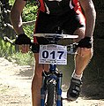 Mountain bike orienteer with a map board on bike handlebars


Competition types edit

Orienteering events can be classified in many different aspects:[38]
- By method of travel: FootO, SkiO, MTBO, etc.
- By the length: sprint, middle, long
- By the time the competition was held: day, night
- By the number of competitors: individual, team, relay
- By the visiting order of controls: cross-country (in a specific order), score (free to decide order)
Long edit
Classic orienteering involves a race between controls in a preset order. The winner is the person who completes the course in the shortest time. This is called a "cross-country" course as distinct from a score course (see below). Courses are normally designed so that the fastest route is not straightforward to find on the map, or to follow on the ground. The classic race has a typical winning time of 75–90 minutes. As of 2007, the IOF have dictated that the "classic" course should be redesignated the "long".
Middle edit

The middle distance is a shorter cross-country race than the classic (or long), with a winning time in the region of 30 minutes and with an emphasis more on fine navigation than route-choice. When races of this distance were run in the mid-late 1990s, they were called "short" races, or "sprint-O". The short distance was introduced as a world championship discipline in 1991. More recently, though the IOF have renamed this distance as "middle".
Relay edit
A relay race is run by a team of competitors each running a course, and the result is based on the team's total time. Relays usually employ a mass start instead of a staggered start. Relays are part of World Orienteering Championships both as sprint relays and as cross-country relays. Additionally, there are popular mass club races out of which Jukola relay has the highest number of participating clubs 1,787 (in 2015), while 25-manna has the highest number of legs 25. To reduce competitors following each other, various spreading methods might be used. This is called "gaffling", which is a Swedish word meaning "forking". The key principle is that every team must run every leg (between each pair of two controls), but not necessarily in the same order. The IOF have introduced the nomenclature to try to clarify the usage of the word "leg". In orienteering usage, leg normally refers to the part of a race between two control points. In relay (non-orienteering) usage, leg refers to the part of a race run by a single team member. The IOF prefer "lap" for this latter term, but despite this, in common parlance, "leg" is used for both terms.
Score edit
Competitors visit as many controls as possible within a time limit. There is usually a mass start (rather than staggered), with a time limit. Controls may have different point values depending on difficulty, and there is a point penalty for each minute late. The competitor with the most points is the winner. The large-scale, endurance-style version of a Score-O is known as a rogaine, competed by teams in events lasting (often) 24 hours. A very large area is used for competition, and the map scale is smaller. The format originated in Australia. The term ROGAINE is often said to stand for Rugged Outdoor Group Activity Involving Navigation and Endurance; this is essentially a backronym, as the name actually originates from the names of Rod, Gail and Neil Phillips, who were among Australian Rogaining's first participants.[39]
Sprint edit
Very short races, with winning times in the region of 12–15 minutes, often held in city parks and other more urban settings. Map scales are usually 1:5,000 or 1:4,000. Control sites can include benches, litterbins, sculptures, and other objects common to urban parks.[40] The sprint distance may also be held in the forest, when it would be called a "forest sprint" as opposed to an "urban sprint". This distance was pioneered in the late 1990s as an elite event by the Park World Tour organisation who organised an independent "world cup" in park sprint orienteering. In 2001 in Tampere, the IOF included a sprint distance in the orienteering world championships.
Ultrasprint edit

Ultrasprint events are held in a specially constructed labyrinth. Due to the limited area of the labyrinth, ultrasprint is a more spectator-friendly form of orienteering. Also, as the course is artificial, identical courses can be set in different geographical locations for simultaneous local competitions as parts of a larger tournament.[41][42]
Night edit

Competitors use a headlamp to navigate in the dark. Reflective markers often are used on control point flags, which shifts the tactics from precision navigation to searching. Competitors can travel at high speed to the vicinity of the control point, then sweep the area with the light to catch a reflection off the control flag. If a night event starts before dark, a mass start must be used so all competitors have equal time in the light and dark. The two classic club relays, Tiomila and Jukola, both include night legs.[43] Full length (24-hour) rogaines and many adventure races run through the night, without a light period, and competitors may choose not to rest.
String edit
Competitors follow a string around a short course, noting down things that they find on the way. This is generally used by young children and people new to the sport who want to find out what it is like.[44]
Precision edit
Precision orienteering generally is not a speed event, but rather a test of the competitors' ability to precisely match map and terrain. Examples include trail-O (untimed), TREC style mounted orienteering, and Radio Orienteering in a Compact Area (ROCA). Both trail-O and ROCA use decoys in the vicinity of the control point.
The Olympics edit
Efforts begun in 1996 to promote the inclusion of orienteering in the Olympic Games have so far been unsuccessful, although orienteering became a sport in the World Games in 2001, and is a sport in the Summer Deaflympics. Supporters recognize that the sport is neither television- nor spectator-friendly, the venue of competition is often necessarily remote from major cities, and the duration of the event is longer than most other individual competitions.[45] Efforts to develop a format suitable for Olympic competitions have focused on park orienteering, micro-orienteering, and short-distance relays. Sprint Orienteering on foot as a format of the sport is most likely to be included in Olympic Games, as this discipline is becoming more and more popular worldwide and can have a significant spectator interest. According to the website of a Chicago Orienteering club, "the International Orienteering Federation is committed to entering the Olympic World."[46]
Although not an official demonstration sport, an international ski-orienteering event was held in Sugadaira Kōgen, Japan, as part of the International Cultural Festival held in conjunction with the XVIII Winter Olympic Games in Nagano in 1998.[47] The International Orienteering Federation petitioned the International Olympic Committee in 2002 to include ski orienteering in the 2006 Winter Olympic Games, noting that it could share the venue with the biathlon competitions.[48] In its formal recommendation that ski orienteering not be included in those games, the Olympic Programme Commission focused on a lack of participation in the sport outside Nordic countries, "the challenges for broadcasters and spectators to easily follow the competition", and the costs associated with new technology and a new results system.[49] In 2005, the International Olympic Committee confirmed that ski orienteering was under consideration for inclusion in the review process of the Olympic sport program for the 2014 Winter Olympic Games.[50] On 28 November 2006, the Executive Board of the IOC decided not to include any new sports in this review process.[51]
World Orienteering Championships edit
The World Orienteering Championships (WOC) is an annual event organised by the International Orienteering Federation. The first World Championships was held in Fiskars, Finland in 1966. They were held biennially up to 2003 (with the exception of 1978 and 1979). Since 2003, competitions have been held annually.
The format of the World Orienteering Championships alternates every 2 years, with even years hosting sprint format events and odd years hosting forest format events.[52] As of 2019[update], when applying the Olympic-style gold first rankings method to medals won at the World Orienteering Championships, Europe has been dominant, with Sweden's 171 medals won marking them as the most successful world championships nation.
Semiotic Research edit
Finding the way around the outdoors is still very important. When people visit National Parks or other wild lands, they need to know where they are going on trails and paths. Over the years nature changes. Trees grow and fall over, wildfires occur, and floods take place. Therefore, signage and environmental markers need to change too. In one study, National Park staff asked 36 participants to think out loud while going through the park, reading the park map, and interpreting signage throughout the park. The researchers analyzed and reviewed the participants’ comments to evaluate signage design and placement. This helped the staff understand how to improve signage so that hikers felt more at ease and oriented. Novice hikers, especially, may not understand non-textual hiking signs such as blazes, cairns, and ducks.[53]
Other studies have focused on novice orienteers solving orienteering tasks. One involved eight hiking volunteers. Half did a recording and audio during the hike while half verbalized after the hike what they saw and experienced. Hikers described their orienteering activity and made suggestions on how to improve the teaching of orienteering and orienteering practices.[54]
A central problem is map reading skills and understanding the imprecision of maps as a scaled down abstraction of an area at a single point in time. Hikers unused to orienteering often lack these skills and this understanding. Also, there are many kinds of maps, people need to be aware of the differences, what type of maps will work best for them, and particular issues such as scale and magnetic declination.[55]
Semiotics is an important tool to improve one's understanding of maps and way-finding in the outdoors. Topography and symbols for water, trees, private vs. public land etc. are all important semiotic markers for reading maps, orienteering, and finding one's way around the wilderness. Map symbols need to be simple, understandable, and meet professional cartography standards. Carto semiotics helps make sense of symbols used in different types of maps such as globes, relief models, and animations. Carto semiotics also includes the study of map keys, legends, and units of measurement between destinations.[56]
See also edit
References edit
- ^ "About Orienteering". The Canadian Orienteering Federation. Archived from the original on 2008-10-02. Retrieved 2008-08-11.
- ^ "Orienteering". International World Games Association. Archived from the original on 2006-01-08. Retrieved 2008-09-29.
- ^ "Sports". World Police Fire Games. Archived from the original on 2008-10-01. Retrieved 2008-09-29.
- ^ a b c "Past & present". International Orienteering Federation. Archived from the original on 2008-08-02. Retrieved 2008-09-28.
- ^ "Milstolpar i utvecklingen" (in Swedish). Svenska Orienteringsförbundet. Archived from the original on September 26, 2007. Retrieved 2008-09-29.
- ^ "National Federations". International Orienteering Federation. Archived from the original on 2006-12-27. Retrieved 2006-02-19.
- ^ "Orienteering: A Brief History". Orienteering Australia. Archived from the original on 2008-07-19. Retrieved 2008-11-13.
- ^ Pulkkinen, Sanna. "The Jukola Relay is about much more than orienteering". Helsingin Sanomat. Archived from the original on 2007-06-29. Retrieved 2008-11-13.
- ^ "Park World Tour". Retrieved 2021-06-25.
- ^ "British Orienteering Rankings". Retrieved 2012-02-05.
- ^ "About us". International Orienteering Federation. Archived from the original on 2008-08-02. Retrieved 2008-08-11.
- ^ "Rules and Guidelines". International Orienteering Federation. Archived from the original on September 25, 2008. Retrieved 2008-09-28.
- ^ "About us". International Orienteering Federation. Archived from the original on 2008-07-25. Retrieved 2008-05-26.
- ^ "IOF Office". International Orienteering Federation. Archived from the original on 2022-07-25. Retrieved 2022-07-25.
- ^ "Vision and values". International Orienteering Federation. Archived from the original on 2008-07-25. Retrieved 2008-05-26.
- ^ "Past & Present". International Orienteering Federation. Archived from the original on 2008-08-02. Retrieved 2008-09-28.
- ^ "About British Orienteering". British Orienteering Federation. Archived from the original on 2008-01-27. Retrieved 2008-05-25.
- ^ "BAOC Online". baoc.org.uk. Retrieved 2008-09-28.
- ^ "International Rogaining Federation". www.rogaining.com. Retrieved 2008-10-28.
- ^ "International Amateur Radio Union". International Amateur Radio Union. Retrieved 2008-11-13.
- ^ a b "Your first orienteering event". orienteer.com. Archived from the original on 2008-05-16. Retrieved 2008-09-28.
- ^ "Foot Orienteering". Orienteering Queensland. Archived from the original on 2007-02-24. Retrieved 2008-09-28.
- ^ "International Specification for Orienteering Maps" (PDF). Archived from the original (PDF) on 2011-10-19. Retrieved 2011-12-03.
- ^ "The Map". www.williams.edu. Retrieved 2008-09-28.
- ^ a b c "Details of the sport of orienteering". Archived from the original on 2001-04-12. Retrieved 2008-09-28.
- ^ "Courses and classes - cutting through the confusion" (PDF). Cyprus Orienteers. 1997. Archived from the original (PDF) on 2015-09-04. Retrieved 2015-02-16.
- ^ "Orienteering Clue Symbols". www.williams.edu. Retrieved 2008-09-28.
- ^ "Orienteering". www.runningforfun.co.uk. Retrieved 2008-09-28.
- ^ "Permanent Courses". US Orienteering Federation. Retrieved 2012-05-04.
- ^ "Permanent orienteering courses". South London Orienteers and Wayfarers. Archived from the original on August 28, 2008. Retrieved 2008-09-28.
- ^ "IOF Control descriptions" (PDF). International Orienteering Federation. Archived from the original (PDF) on 2011-07-27. Retrieved 2008-09-30.
- ^ "Your first orienteering event". orienteer.com. Archived from the original on 2005-12-21. Retrieved 2008-11-13.
- ^ "Appendix I : Electronic Punching" (PDF). www.britishorienteering.org.uk. Archived from the original (PDF) on 2008-08-07. Retrieved 2008-10-23.
- ^ "Organisers are responsible for". British Orienteering Federation. Archived from the original on 2008-08-04. Retrieved 2008-11-13.
- ^ "IOF Foot-O Rules". Archived from the original on 2008-06-14. Retrieved 2008-11-14.
- ^ "BOF Event Rules" (PDF). Archived from the original (PDF) on 2008-07-04. Retrieved 2008-11-14.
- ^ "Australian Orienteering Rules" (PDF).
- ^ "IOF rules" (PDF). orienteering.org. 2018. Archived from the original (PDF) on 2017-12-15. Retrieved 2017-12-15.
- ^ "Point-to-point orienteering (also called Cross-country orienteering)". Retrieved 2008-05-08.
- ^ "International Specification for Sprint Orienteering Maps" (PDF). International Orienteering Federation. April 15, 2008. Archived (PDF) from the original on 2005-05-06. Retrieved 2008-09-28.
- ^ "Sheffield Ultrasprint".
- ^ "Sport Labyrinth".
- ^ "Night Navigation". Retrieved 2008-05-08.
- ^ "The String Course". Orienteering USA. Retrieved 2012-05-04.
- ^ Brady, Gerry (2008). "The Olympics, Orienteering and Ireland" (94 ed.). The Irish Orienteer. Retrieved 2008-08-16.
- ^ "Current Status of Orienteering in the Olympics". Chicago Area Orienteering Club. Retrieved 2008-09-28.
- ^ "Extensive discussion on the Olympic item". International Orienteering Federation. Archived from the original on December 1, 2006. Retrieved 2008-09-28.
- ^ Rönnberg, Barbro (March 2002). "Ski Orienteering's Olympic Bid". O-zine. International Orienteering Federation. Archived from the original on December 9, 2006. Retrieved 2008-09-28.
- ^ Cararro, Franco (2002). "Review of the Olympic Programme and the Recommendations on the Programme of the XX Olympic Winter Games, Turin 2006" (PDF). Olympic Programme Commission. Archived from the original (PDF) on 2005-05-13. Retrieved 2008-09-28.
- ^ Barbrod, Rönnberg (December 2005). "Green light for continued Olympic campaign" (PDF). O-Zine. International Orienteering Federation. Archived from the original (PDF) on December 9, 2006. Retrieved 2008-09-28.
- ^ "Olympic programme updates". International Olympic Federation. Retrieved 2008-09-28.
- ^ "World Orienteering Championships 2023 awarded to Switzerland and WOC 2025 to Finland | International Orienteering Federation". orienteering.sport. Retrieved 2021-06-06.
- ^ Soh, Boon Kee; Smith-Jackson, Tonya L. (2016-11-05). "Designing Cues for Recreational Parks to Support Wayfinding Behaviors". Proceedings of the Human Factors and Ergonomics Society Annual Meeting. 47 (6): 913–917. doi:10.1177/154193120304700616. S2CID 129167796.
- ^ Saury, Jacques (2014). Comprehensive Analysis of Navigation by Novice Orienteers Based on Two Orienteering Tasks. France: De Boeck Supérieur. ISBN 9782804189907.
- ^ Biegler, Robert; Pfuhl, Gerit (2017-02-09). "Do humans know the imprecision inherent in a map?". Meta-carto-semiotics. 4 (1): 15–19. ISSN 1868-1387.
- ^ Schlichtmann, Hansgeorg (Spring 2019). "OVERVIEW OF THE SEMIOTICS OF MAPS" (PDF). Archived (PDF) from the original on 2015-05-13.