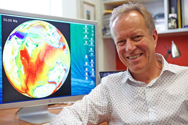
By the time Dietmar Mueller arrived at the University of Texas as a graduate student in the mid-1980s, scientists had already long embraced a once-astonishing idea: that the continents on which all human history has unfolded, rather than fixtures of constancy, were orphans of a former grand supercontinent called Pangaea. Showered with awards, the pioneers of this theory—plate tectonics—had by and large dispersed in search of the next big challenge.
But Mueller and his classmates sensed far more ground to cover. Three decades later, Mueller, now at the University of Sydney, is part of a new upheaval in tectonics, this time ignited by advances in computing power. The same leaps in big-data analysis, supercomputing, and intelligent algorithms that have shaken up finance, genetics, and espionage are transforming our view of the elusive ancient world.
These tools are allowing Mueller and a bold group of scientists, known as paleogeologists, to chart not only Pangaea, but the supercontinents that came before it, with the aim of producing the most precise map of the Earth and its natural resources ever known.
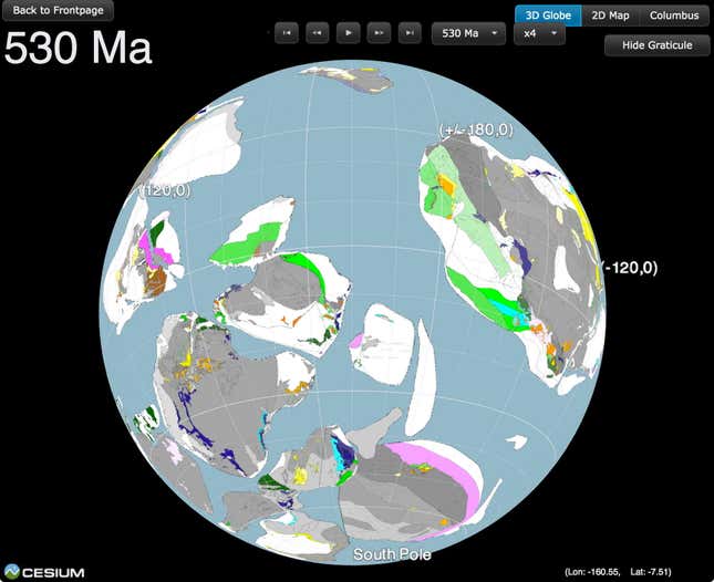
Already, Mueller’s team, working with collaborators at the University of Oslo and Caltech, has completed a stunningly detailed digital reconstruction of 410 million years of earthly history, going back to the collision of then-existing continents that created Pangaea. In January, they plan to release version 2.0 of GPlates, an open-source software model that anyone can use to go back in time to the early days of Earth. Next, they are preparing for peer review of an extension of the model to 1 billion years ago—the era of Pangaea’s ancestor, a supercontinent called Rodinia. Then they will lunge again—to 2 billion years, yet another supercontinent, and the evolution of the first multicellular life.
To some degree, paleogeology is merely an academic enthusiasm. But it’s also serious business. It is essential, for instance, to virtually all deep-water oil prospecting: Oil companies note where petroleum has already been found, and decipher where that reservoir was situated during the time of Pangaea; in what’s called “analog exploration,” they then take a hard look at the rock with which it was conjoined 200 million years ago, and often drill there, too. When it comes to jewels and minerals, the time scale goes past 1 billion years.
Plate tectonics influences present-day politics, too: It created the geography and geology that set the boundaries of countries, parcel out their natural wealth, and determine which ones will be hit by earthquakes, tsunamis and volcanoes. Moreover, some geologists who study the universe think that plate tectonics, which were crucial to the evolution of complex life on Earth, may be a prerequisite (pdf) for its emergence on other planets too. If so, that would narrow down the search for life elsewhere in the galaxy; scientists are already devising ways to detect signs of tectonics on exoplanets, such as traces of volcanic activity that might be spotted with near-future telescopes.
“It’s like detective work,” Mueller said. “You have pieces of evidence. You have to find who committed the crime.”
The accidental discovery of the Earth’s inner engine
The story of plate tectonics goes back to 1912, when a German atmospheric physicist, Alfred Wegener, looked at a map and noticed that the opposing coastlines of Africa and South America seemed oddly congruent, like matching pieces of a jigsaw puzzle. Other geologists had remarked similarly, and in fact written that the two continents were once conjoined. But somehow these declarations had escaped both serious scrutiny and general notice.
Wegener—unburdened by any prior geological expertise—launched into frenetic research. Among the facts he turned up were that the highlands of Scotland seemed to continue in the Appalachian Mountains of the United States, separated only by the Atlantic Ocean; the fossils of similar animals and plants had been found on both continents. He concluded with a sweeping observation: The lands as we knew them had been arranged by continental drift, a process by which all the continents had begun their existence fused into one gigantic expanse that he called Pangaea, or All Earth.
He convinced few contemporaries. Around the world, especially in the United States, hostile geologists denounced Wegener as a dilettante, a superficial interloper, and just dead wrong, according to Mott Greene, the author of a new biography of him. The coastal likenesses were a coincidence, they said. In 1930, the discredited Wegener died on Greenland in yet another attempt to find physical proof of the theory.
It took four decades before a chance discovery revived his theories. In World War II, the US Navy had recorded sonar and other readings to track and evade German submarines, an exercise that resulted in spectacular maps of the seafloor. The Navy was so beguiled that, once the fighting was over, it poured funding into continued ocean research. In the 1950s, American and British scientists studying the Earth’s crust at the sea bottom discovered that the Earth’s magnetic field wasn’t stationary as was supposed, but had regularly flipped throughout history. The “magnetic signature” it left behind in rocks as they cooled and formed pieces of crust showed that at times, magnetic north was near the geographic north pole, and other times the south pole. But the signatures were confusing—they made it seem as if the magnetic poles hadn’t just flipped, but also moved all around the Earth’s surface. In a flurry of papers through the 1960s, however, the scientists cleared everything up—it was the continents that had moved. Generally speaking, Wegener had been right.
Only generally speaking, though. The continents themselves did not actually drift; they instead were found to rest like light Styrofoam atop slabs of dense rock—tectonic plates millions of square miles in size, made of silicon, magnesium and aluminum. It was the plates that jostled for position, pushing up mountains, shifting and causing earthquakes, interacting with the mantle below in a churning system that produced volcanoes—in effect a living machine, taking the land masses along with them for the ride.
Plate tectonics became a sensation. Newspapers around the world described it as a revolutionary conceptual breakthrough, comparable to Darwin’s theory of evolution.
Yet until recently, much of the research was being conducted with primitive tools that provided only the vaguest picture of what was really going on.
The search for a tectonic time machine
When the Earth formed 4.6 billion years ago, it had no plate tectonics, and no one knows when or how the process got started. Yet life as we know it simply wouldn’t exist without it.
Essentially, the Earth is a heat-driven engine, 6,000°C (nearly 11,000°F) at its core and a maximum of 40°C or so at the surface. The temperature difference drives currents in the magma, the molten rock under the Earth’s crust. The tectonic plates move atop these currents. Their movements power the essential system of carbon recycling that—until our industrial civilization came along—kept the level of carbon dioxide (CO2) in the atmosphere optimally balanced; they prevented Earth from turning into an overheated wasteland like Venus.
A similar process also enriches the atmosphere with nitrogen, which is essential to the bacteria and plants that convert CO2 into oxygen, making more complex forms of life possible. (Before life got started, the atmosphere had only a trace of oxygen.)
Finally, plate tectonics are in part responsible for the earth’s magnetic field. This field shields the planet from the solar wind, the torrent of charged particles and radiation from the sun that, undeflected, would deplete the atmosphere and threaten life itself.
To Mueller, considering all this in the early 1990s, now with his PhD and a position as a lecturer at the University of Sydney, what was missing was a reliable, mathematically grounded model that would make sense of the entire geological show from start to finish.
As a field, paleogeology had stayed on the boil. After Pangaea was accepted, scientists had excited a new stir by assembling geological evidence of prior supercontinents: first Kenorland, which would have broken up some 2.4 billion years ago, then Nuna, and after that, about 1 billion years ago, Rodinia. By this stage, multicellular organisms had appeared in the oceans, but the land would still have been bare of anything but bacteria and some algae. Rodinia begat Pangaea, which has hosted all of the complex plant and animal history with which we are familiar.
But what did these supercontinents look like, and how did they visually interact with the earthly core and the atmosphere? Mueller was intimately familiar with widely available short animations of the Pangaean breakup (such as the one below), because many of them went back to his supervisor at Austin, a pioneer of the field named Christopher Scotese. There were also hand-drawn illustrations of lush landscapes teeming with strange flying and terrestrial reptiles, savannah, coral and jungles. But neither Scotese, Mueller nor anyone else could be certain these were reliable.
This was the defining tension underlying the half-century-long study of the supercontinents: That, unlike in other fields that deal in the very old, the scientists had no time machine. Astronomers, by looking through telescopes at galaxies billions of light years away, are transported back to the early universe. Paleontologists, by stumbling on ancient fossils, can look directly at remnants of prehistoric life. But no instrument or evidence had ever similarly teleported their paleogeologist comrades back to the age of supercontinents.
Instead, paleogeologists painstakingly pieced together their theories using disparate fragments of clues, mainly from the magnetic signatures in old rocks. At first, to give their field a face, they translated these clues into cut-out shapes on paper or in Adobe Illustrator, and strung them together into mosaic-like animations still found today on Google.
But while pretty good as far as they went, most such depictions were faulty in important ways. Among the unavoidable imperfections was their typical reliance on a “flat Earth,” two-dimensional illustrations that distorted the appearance and movement of the continents. In addition, they provided plate movements, but ignored the inextricable system that penetrates thousands of miles into the bowels of the Earth, linked all the way to the core.
Then there was the problem with longitude. The paleomagnetic signature gave scientists evidence of the latitude of a long-vanished land—how far north or south it was—but not its longitude, its position east or west. And even on latitude, errors of up to 10 or 20 degrees, meaning as many as 1,400 miles, could creep in if you went back far enough, and the age of rocks could be off by as many as 60 million years. Neither could you tell from the magnetic signature whether a continent was north or south of the equator, right side up, or upside down.
Finally, classic depictions of the supercontinents embraced Wegener’s flawed original thesis of drift. They allowed the continents to wander across the globe without respect to the anchoring plates. In reality, the continents have a sort of underlying keel that connects them to their plate, which prevents them from independent movement.
Thus, the world of Pangaea and its breakup as presented in the animations was more or less informed fiction—close approximations, but with considerable flaws.
Mueller and his collaborators set out to change that—to produce a model anchored in tectonic geometry, showing the boundaries and seamless motion of the dozen or so major plates, without gaps between them, fully integrated with the convecting mantle, and including a more rigorous appraisal of the correct longitude. It would be what he called a virtual time machine that would allow anyone to pick almost any point in the long-ago geological eras on Earth, and return there.
As it was, no widely available software could accomplish all of this. Oil companies and some other small teams of geologists had systems they had created, but didn’t share them with others. Nor was it clear, in any case, that any of them achieved Mueller’s aims. So Mueller, along with geophysicist Mike Gurnis at Cal Tech and geologist Trond Torsvik of the University of Oslo, banded together to create it themselves from scratch. Mueller named his team EarthByte, and the system he created with Gurnis and Torsvik is now called GPlates.
“We don’t just want to make inferences about what happened in the past,” Mueller said. “We actually want to travel into the geological past, and understand what the planet looked like, not only at the surface, but also at depth, in fact all the way to the core.”
Applying the rules of plate tectonics
Mueller’s initial aim wasn’t superlatively ambitious. He just sought to create an open-source platform on which geologists could reconstruct the post-Pangaea Earth digitally, so that state-of-the-art “deep time” paleogeology would no longer be the province solely of oil companies and well-heeled research groups.
Nor, even when he and his collaborators went further and began to reconstruct the supercontinents, did they presume to research the whole of earthly history from scratch. Rather, like Wegener, they would synthesize the decades of research that was already out there. Using fast supercomputers, they would try out different possible scenarios of continental evolution, and then settle on the depiction that best fit the existing data and how tectonics were known to work.
The team’s first goal was to create a program that would model a plate’s movement not on a flat piece of paper, but on a sphere. The continents were given multiple axes, or rotations, allowing the land and plates to move independently, which they appear to do if you do not know they are connected. (The old models generally got the continents right, but took no account of the boundaries and movement of the plates.)
One of their biggest advances was in strictly modeling the globe according to a set of laws—the “rules of plate tectonics”—that scientists have gleaned from decades of meticulous study of the sea floor. One version of these rules goes back to Scotese, but the Sydney group and others have updated them.
For instance, no continent can exceed a speed limit of 20 centimeters a year, but ocean floors can move faster than continents. Generally speaking, continents cannot make abrupt, jerky movements (although, as Scotese says, “every once in a while … wham!”). Large continents have never rotated completely around, or even by 180 degrees, over just a few tens of millions of years. And, aside from the occasional wham, the affairs of the Earth have generally unfolded slowly and smoothly. Continents cannot jump north, then south, then north again. Nor can they flounce, twist, lurch or vault.
Here is a depiction by the Sydney group showing the speed of the Pangaea breakup.
A key thing that made this possible was leaps in computing power. The kind of brute force required, Mueller said, was generally not available for use by academic geologists. When time could be arranged on a fast computer, it could take 10 days or even two weeks to run dozens of possible configurations of the solid Earth over a 250-million-year period, to figure out which one was the likeliest to be correct. The latest supercomputers, though, can do the same work in three or four days.
One of Mueller’s researchers, Kara Matthews, recently finished knitting together two models of the pre- and post-Pangaean eras—one that went to 230 million years ago (230 Ma, in the standard notation), and the second from there to 410 Ma. The former is Mueller’s and the latter was created by Oslo’s Torsvik and a postdoc named Mathew Domeier. Both pieces are regarded as standard works, and the challenge for Matthews was mainly how to make them seamlessly work together. The result is an exhaustive model in 1-million year increments, much more granular than the 10-million-year intervals used in prior depictions.
Another big advance is that the new model seeks to correctly place the continents longitudinally. Torsvik had used an experimental method that he argues correctly finds longitude. (In April he will be awarded the prestigious Arthur Holmes Medal in part for his pioneering work on the method.) It relies on what he believes are lodestars—enormous chunks of superlatively old, deeply buried rock with the inelegant names Large Igneous Province (LIP) and Large Low Shear Wave Velocity Province (LLSVP).
In a 2014 paper, Torvsik asserted that his longitudinal method works at least as far back as the Cambrian explosion of 540 Ma, when the diversity of life experienced a momentous increase. One key reason is the stability of two LLSVPs (one below Africa and a second underneath the Pacific), which, unlike much of the Earth’s land mass, appear to have stayed almost immobile since the Cambrian explosion. While everything else on the planet was moving around through time, the LLSVPs were not, and thus are fixed longitudinal references.
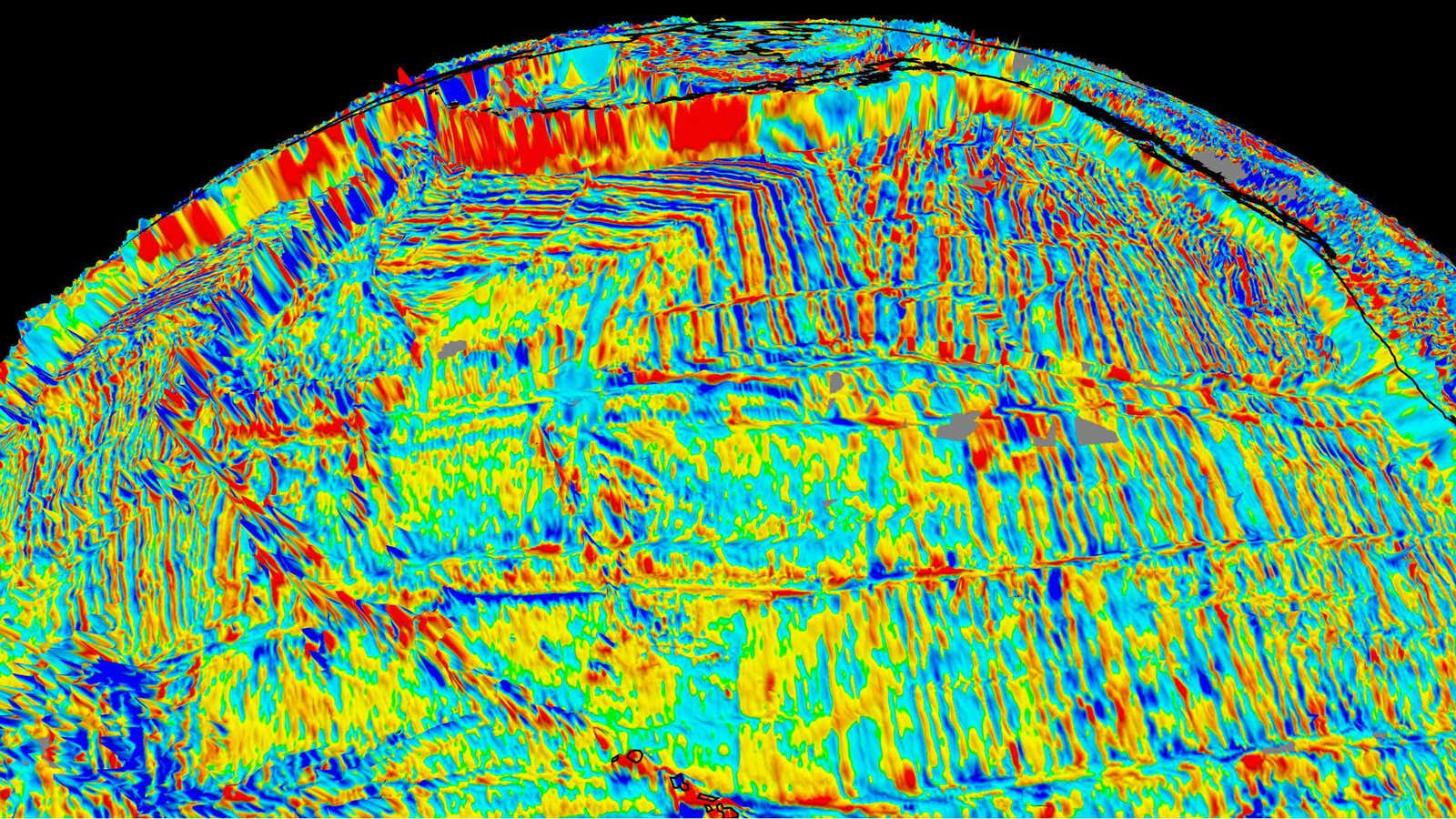
Another key advance in Matthews’ combined model is in unifying the surface with the deep Earth all the way to the core. Distinct from competing animations, which feature only the land masses on the surface of the globe, the GPlates model reveals the moving, roiling Earth underneath, in addition to the tell-tale appearance of the reversing magnetic lines on a spreading Atlantic Ocean.
But while thrilling, that would be almost an anti-climax if Mueller’s team stopped there—if they did not now set out to extend the GPlates model to Rodinia and beyond. Which is what came next.
Reconstructing Rodinia
When the existence of Rodinia was first proposed in the 1970s, it suffered some of the same ridicule as Wegener’s original theory. Zheng-Xiang Li, a professor at Curtin University and one of the world’s foremost experts on Rodinia, said that all through the 1980s, he risked professional scorn to suggest that there had been a cycle of supercontinents—“cycles was a bad word,” he said. The most daring acceptable hypothesis was that Pangaea was an accident, or at most an “episode,” words that did not necessarily suggest that it had predecessors. As for Rodinia, its name had not even been coined yet. The orthodoxy was that Pangaea was unique and discreet.
All that changed in the 1990s with the publication of landmark papers that began to document Rodinia’s existence, starting with the presence of extremely old slabs of rock in the interior of the existing continents—billions of years old, it would be later discovered, based on potassium argon dating. The cratons, as they were called, were usually encased in much younger rock, implying their separate origin long before. They were often hundreds of thousands of square miles in area, and penetrated hundreds of miles into the Earth. Rocks of similar age were found strewn across the planet—in Sweden, Mexico, Mozambique, Australia, Antarctica—suggesting that all were once part of the same, much larger expanse. The new canon now embraced Rodinia.

Last year, with Pangaea out of the way, Mueller assigned a PhD student—a wild-haired opals expert named Andrew Merdith—to start work on extending the GPlates model to Rodinia. But how? The further back in time you went, the fewer and fewer rocks you encountered—the evidence required to make any accurate picture. The plates themselves were different—some had been swallowed up into the Earth’s mantle; many had broken into pieces; most were different shapes. The oldest verified crusts—in Australia and Canada—are about 3.8 or 4 billion years old, but they are extremely lucky to have escaped destruction.
However, Merdith was not starting from scratch. There were the known cratons into which Rodinia was thought to have broken up: four pieces in Africa, for instance—Congo, the Kalahari and the Sahara, not to mention West Africa, which had been conjoined with Amazonia (of today’s South America) in the Rodinia days. There also was a quarter century of research papers, including the work behind those hand-drawn animations on Google (below).
Most important, he had Li, the Rodinia expert at Curtin. Li had already co-led a five-year United Nations-funded project that, finishing work in 2004, had produced a model of the supercontinent, although it was not loaded into GPlates. He agreed to collaborate with the younger man.
The resulting model would aim to be the likeliest facsimile. It would be the first that knitted together the post-Rodinian plates, and presented the period from 1 billion to 410 million years ago not as fragmented snapshots, but as a single piece, all anchored in the tectonic rules. Merdith said, “We’re not experts in any one particular area—on the Australia and India collision or the South America collision with Africa—but we’ll get the model out and give it to people and say, ‘Great, you know more about how South America works than we do. So you fix it or tell us what is wrong and we can fix it.’” It will be “a benchmark foundation for people to use to improve their models.” That was his and Mueller’s hope, anyway.
Baby steps towards a billion years ago
When Li’s work arrived in Sydney, it was clear to Merdith and his supervisor, a Briton named Simon Williams, that a few things were off. Li’s model violated at least a couple of the more serious tectonic rules. “We went through and there were some periods of time when the Chinese and Siberian plates were doing crazy stuff, moving really fast and rotating,” Merdith said. “If it was north at 900 million years, by 800 it was south-facing, and then at 700 it was east or west, which if you judge by the tectonic rules, are erratic and far too fast.”
But that would be relatively easy to fix. The tougher task was that, while the Li model was a respected depiction of the breakup of Rodinia and the movement of the subsequent continents, it did not attempt to find the boundaries of the tectonic plates on which the continents lay. When Kara Matthews had done her Pangaea section of the GPlates model, the plate boundaries had already been configured by her Oslo collaborators. But between the eras of Rodinia and Pangaea, some plates would have broken up or changed, and the geological evidence for what had existed so long ago was much more scant. In this regard, the existing models of Rodinia were more like guesswork, and redolent of Wegener’s theory of drift.
Merdith himself, therefore, had to decide the size, shape and boundaries of the plates. To get there, he took the clues at hand, such as the known age and thrust of a mountain range, the cratons, and the paleomagnetic evidence. He knew that if he could get the model right from 410 Ma—where Matthews’ work ended—through about 750 Ma, he would be pretty much home, because Rodinia would not have shifted much if at all from then to 1 billion years ago, which was about when the supercontinent formed. So what he had to document was a roughly 350-million-year gap.
Getting to work, Merdith made an adjustment for Li’s erratic China and Siberia, finding an interpretation of the data that moved them from the center of action to the periphery of the main blocks of land, and allowed for a smoother smashing together of continents. This was artistic license; it was possible to look at the same data and reach different conclusions as to the appearance of geological scenes.
Now Merdith set out to advance methodically through the whole period. He established small daily goals—working on a 50- to 100-million-year time interval on one part of the globe, then another, and another. First, he tackled the continent of Gondwana, from 520 Ma to 650 Ma, the period about which he had the most information. He scanned academic papers written over the years, with an eye on figuring out the all-important plate boundaries. He saw that the timing seemed off for the collisions of Australia, Antarctica, Africa and India—they did not mesh with new data he had collected. So he began to adjust the model accordingly. He fit together the pieces of Africa, but now found that that forced Australia out of the picture. He had to return to the data on Australia. He made a new tweak that worked it back in. Now he moved on to South America, and the then-existing continents of Lorentia, Baltica and Rio de la Plata, which is more or less present-day Uruguay.
But all of that came in stretches. He found he could complete a small block of land in South Africa in a few days; but he was spending several weeks on larger blocks like India and Australia.
The model was moving in increments of 20 or 30 million years, much less fine than the 1-million-year granularity of Matthews’ Pangaea-era model, but it was what the data made possible. In some spots, there were no data at all, which forced him to hand-draw what made the most sense given the tectonic rules.
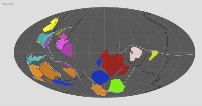
By October, Merdith had a rough cut covering the period 500 Ma to 650 Ma (see below). Now he jumped all the way back to 750 Ma—when Rodinia started to break up. He was still tweaking the plate boundaries, hoping that when he was done, the result would align with those he created for 650 Ma “and really flow in together.” Merdith had a personal deadline—he was getting married half-way through December, and by then had to reach 750 Ma with a model in which “everything [was] moving as one big block on the Earth’s surface.”
“It’s baby steps,” he said. “You do a little bit each day and it doesn’t feel like you do much. Then you look back after a few months and you have a model that is coming together nicely.”
The applications for geology and climate change
The GPlates system that Mueller’s team developed isn’t good only for tracking continental evolution. It’s general-purpose mapping software that lets scientists visualize all kinds of data about the Earth. It’s been used for making a map of how gravity varies around the planet, and how flows of liquid rock deep in the mantle gradually distort the Earth’s surface. And in 2014, Adriana Dutkiewicz, a Polish-born paleogeologist and Mueller’s wife, used it to tackle a problem very relevant to the present day: how the seafloor interacts with the atmosphere and influences climate change. She would lead a project that, for the first time since the 1970s, would comprehensively map the sea floor, this time digitally.
The idea had been around for a long time—to cull a database of some 200,000 seafloor crust samples collected since the 1950s on exploratory ocean cruises, and held by the US National Oceanic and Atmospheric Administration (NOAA). But before Dutkiewicz, no one had been prepared to wade through the mountain of NOAA reports.
With a team including her husband and a machine-learning specialist, Dutkiewicz began to examine the samples. First, there was bad news; the database was faulty. What was written in individual summaries of the initial rock samples she looked at did not always match the samples themselves. So she had to read the research paper attached to every single sample. Only then could she know which ones met GPlates standards.
After three months, Dutkiewicz emerged with 14,500 solid samples. The team fed those into a machine-learning algorithm designed to produce a visual depiction of her conclusions. It spat out an interactive, three-dimensional geological map of the seafloor—a virtual, rotating globe (video below) that she announced in an August 2015 article in the journal Geology. (You can also play with the interactive model online.)
It was widely picked up by mainstream digital media. “People really like playing with things like that on their computers,” Dutkiewicz said. “For an ordinary person, you could see that it’s not just this deep, dark pit full of mud.”
The map means that for the first time, there is an anchored digital model connecting data from the surface of the sea, which is most exposed to the atmosphere and the immediate impact of the burning of fossil fuels, to the seabed itself. Phytoplankton—microscropic marine plants—absorb carbon dioxide from the atmosphere at the surface. When they die, they sink down and coat the seabed in sediments, trapping the carbon there. Collectively, they absorb much more carbon from the atmosphere than plants do on land, Dutkiewicz said. Her map shows where these carbon sinks are concentrated.
But Dutkiewicz said the model shows that scientists understand the sinks much less than they thought. Specifically, there is less of a direct connection between the surface and the seafloor than was previously believed, and the composition of the sediments is much more complex. More research is needed. “We urgently need to understand how the ocean responds to climate change,” she said.
The super-computer and the algorithm had made all the difference to the map’s creation. It had allowed her to connect different data sets together—“really big data sets,” she said. “It wouldn’t be possible to do without a computer. The human mind cannot process all that information.”
Toward a geological time machine
How far back into the history of Earth can you go?
Mike Tetley, a high-school-dropout, former rock bassist, and one of Mueller’s top PhD students, said that paleogeologically speaking, you can go back in time 3 billion years. Before that, there aren’t enough rocks or correlating data to reach any conclusions. At least, not right now.

In 2014, Tetley got talking to Li, the Rodinia expert, who wondered aloud whether there might not be a new way to map the long-ago world, including longitude. The paleomagnetic tools used to date rocks rely on the behavior of igneous rocks (those that have formed from cooling magma) at the so-called “Curie temperature.” When igneous rocks cool to their Curie point, they are left with an indelible impression of the magnetic field at that point in time. From that, researchers decipher the latitude at which the rock formed, but it could not reveal longitude, because the Earth’s magnetic field points north-south, not east-west.
What Li suggested was that Tetley try another experimental method—that he take a look at basalt, one of the most common rocks on the Earth. Basalt had been thought to be impervious to detection of its physical origin, without a directional signature of any type, but Li had a hunch that an algorithm could be written that would crack open its secrets. Only he had no idea where to start.
Tetley offered to have a go. One piece of basalt seemed indistinguishable from another to the human eye, but Tetley went after the problem using machine learning. He loaded up 500 million years of basalt data, gleaned from rock samples catalogued in a global archive. “I said to it, ‘This is what basalt looks like.’ It’s like the ‘50s robots – ‘This is what a woman looks like.’ But I say, ‘This is basalt from a subduction zone. Learn it. These are the basalts from mid-ocean ridges—learn them.’ It learns the patterns of all the things.”
If the method were successful, Tetley said, it could solve the longitudinal problem—“knowing where on Earth it all happened”—because the signature for longitude might be locked into the basalt, in a way previously imperceptible by humans, but that the algorithm could pick up. “You throw all the data in, and the algorithm will deal with it,” he said. “It effectively allows you to identify a rock from any time period if you have some measurements.”
Tetley got the code written, and he and Li ran a test. They took a model of the Earth between 5 Ma and 30 Ma, based on paleomagnetic data. Then they asked Tetley’s algorithm to predict how the continents would have moved over the same period of time, using only the basalt data he had loaded up. There was a 75% match, “which in algorithm land is very good,” Tetley said. “Because we didn’t tell it anything. It used what it knew from data and made predictions on stuff outside its data set.” At least right now, Tetley’s algorithm can’t be used in isolation—for a reliable result, it needs a second source of anchoring data, he said. But it suggests that machine learning can be used to tighten up paleogeological maps throughout ancient time.
Mueller called Tetley “one of those one-in-a-million types,” who is “actually on the path of revolutionizing, I would say, how these deep-time plate reconstructions are done.” To Mueller, this is the long-sought teletransporter. “If the vision is a time machine,” he said, “then that’s not just to travel to a particular place back in time, but to really analyze it. You know, what happened at that time period in many different ways.”
The next billion years
The next step is to combine Andrew Merdith’s data on Rodinia–once it goes through peer evaluation and is published—with Tetley’s algorithm, which should harden the longitudinal placement of the plates and continents. They will add in a database on minerals. The result, among other things, Mueller hopes, will be a predictive tool for mining companies. “It will tell you in which places copper and gold deposits likely formed,” he said.
And this could help to answer the next big challenge—how to go back before Rodinia to the almost data-absent time of its predecessor, the supercontinent of Nuna, which would have formed nearly 2 billion years ago. Li already has a head start on mapping that one, too. “It’ll put us in the position, I think for the first time, to actually study the evolution of the Earth through several supercontinent cycles—supercontinent amalgamation and dispersal, and study, you know, how this affected the deep Earth,” Mueller said. He paused. “This will take time. Obviously, history has taught us that things always take longer than we think. But we have a lot of critical mass and momentum here, and I think over the next few years, we are going to see a lot of exciting things happen.”