Ads by Google
«Back to Homepage
«Information about Brazil
«Climate in Brazil
Temperature in Brazil
See also: Rain in Brazil
The graphics below show average temperatures in Brazil.
Source of information: Brazilian Institute of Meteorology.
Based on data collected from 1961 to 1990.
For comparison purposes, visit this page with statistics about the weather in London.
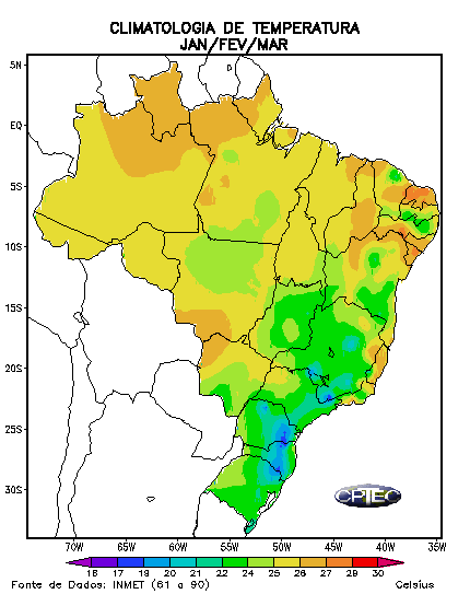 |
Each of the four graphics shows average temperatures in a trimester.
In all maps, the bluer parts are colder, while the redder are hotter. See the exat scale, in degrees Celsius, at the bottom of each map.
First map shows temperatures for the trimester January/February/March, which coincides grossly with the Brazilian summer.
The largest part of Brazil is located between the Equatorial Line (which cuts the norther part of the State of Amazonas) and the Tropic of Capricorn (which passes over the State of São Paulo); as consequence, the entire country is warm or hot during the summer.
The Amazon and the Pantanal are hot and wet. The Northeast is hot and dry. The very few blue spots, where temperature falls below 20 degrees, are areas of high altitude. |
The two maps below show temperatures in Brazil during the Autumn (April/May/June) and Winter (July/August/September).
Even during the colder seasons, the northern part of Brazil enjoys temperatures above 22 degrees Celsius (about 65 degrees Fahrenheit).
The Southern States see a drop in temperature, but rarely does it fall below 10 degrees Celsius. Snowing is seen only at cities of high altitude, and even so, rarely. |

|

|
 |
The last map shows temperature levels in October/November/December, the Brazilian spring season.
Temperatures increase all over the country. Temperatures in the southern States vary around the 20 degrees mark.
In the northern area, the spring is a dry season; this causes temperatures to be comparable and sometimes higher than the summer. |
Back to Top |