Residents in Western Australia’s mid west have been told to take shelter during what their premier has described as a cyclone “like nothing we have seen before in decades”.
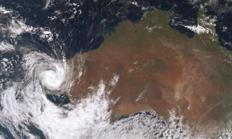
Tropical Cyclone Seroja was expected to make landfall on the WA coast by 4pm local time, bringing with it winds of up to 150km/h.
There was a “red alert” calling for an 800km stretch of coastline south of Carnarvon to Lancelin.
Communities included in this zone were Geraldton, the shires of Carnamah, Coorow, Chapman Valley, Dandaragan, Irwin, Mingenew, Morawa, Northampton, Perenjori, Shark Bay and Three Springs.
“You are in danger and need to act immediately,” WA premier Mark McGowan said on Sunday afternoon.
“This is a very large storm that is posing a very serious threat. Lives and homes are under threat.”
People in red-alert areas must stay at home or inside an evacuation centre.
Evacuation centres are open in Port Denison, Carnarvon and Denham.
Carnarvon’s historic One Mile Jetty was one of the first casualties of the cyclone, reportedly ripped apart around lunchtime on Sunday.
Tropical Cyclone Seroja was expected to continue to impact the area until midnight, with each community expected to experience the worst of the weather for about three hours, the Bureau of Meteorology’s James Ashley said.
Residents of Denham and Kalbarri were likely to experience gales and destructive winds and, if Seroja tracks south. Geraldton may also be impacted.
Abnormally high tides, heavy to intense rainfall, flash flooding, dangerous surf and beach erosion were among the dangers.
Wind gusts and heavy rainfall could be seen as far south east as Esperance, Ashley said.
The WA Country Health Service said Geraldton Hospital would continue to treat emergency patients during the cyclone, but all other appointments have been or will be cancelled.
The Bureau of Meteorology issued a flood watch for the Wooramel, Murchison, Greenough,Yarra Yarra Lakes, Moore, Hill and parts of the Salt Lake District and Avon River catchments.
A severe weather warning was also been issued for Monday for parts of the greater Perth, Goldfields-Midlands, great southern, and midwest-Gascoyne regions.
“If you live in south-east coastal and parts of Goldfields, Eucla, great southern and central Wheat Belt districts you need to get ready now for the severe weather coming tomorrow,” emergency warnings said.
“This is a rare weather event for people in southern and eastern parts of Western Australia.”