
OS Maps: Walking & Bike Trails
4.4star
19.4K reviews
1M+
Downloads

Rated for 3+
info


About this app
Create your adventures your way and let OS Maps guide you on stunning routes across the UK & beyond. Get more from the outdoors, with more freedom to explore, more confidence to tackle that next challenge and more adventures along the way. OS Maps is the official app by Ordnance Survey, & your guide in the great
outdoors.
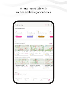
Why you’ll love using OS Maps:
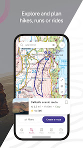
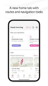
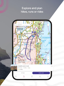
EXPLORE & PLAN HIKES, RUNS OR RIDES
Whether you are planning a walk, hike, run or ride; OS Maps lets you create outdoor adventures with trusted mapping & navigation tools from the experts at Ordnance Survey, Britain’s national mapping service.
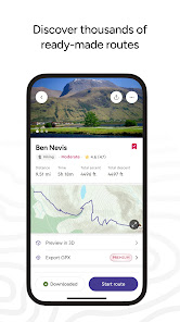
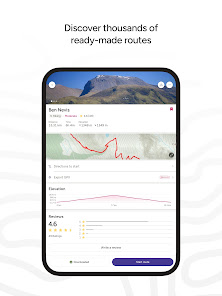
DISCOVER THOUSANDS OF READY-MADE ROUTES
Get outside with curated routes from outdoor experts & organisations such as Trail, Country Walking, Mountain Bike UK, BBC Countryfile and more.
ICONIC OS MAPPING
Subscribe to unlock the detail & accuracy of OS leisure maps including OS Explorer 1:25,000 & OS Landranger 1:50,000. And now with global mapping & topographic mapping for USA, Australia & New Zealand to keep you exploring all over the world.
CREATE YOUR OWN ADVENTURES
Best in class route planning & navigation tools mean you can get off the beaten track & explore with more freedom. Plan routes with quick & easy snap-to-path route plotting, then save & share with your friends to plan that next epic day in the outdoors.
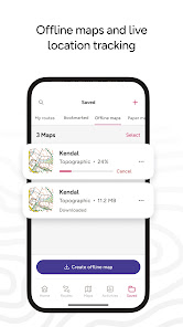
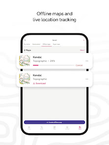
NO SIGNAL? NO PROBLEM
Download maps & routes to your phone to view offline, so they’re ready, whenever & wherever you need them. View any part of GB even without signal and export to your GPS device.
UNLIMITED PRINTING
Print copies of all your routes & maps to take with you, so you always have a backup to hand.
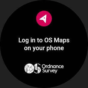
USE ON EVERY DEVICE
Sync your activities between across devices, on desktop & mobile. On desktop, premium users can use our 3D Aerial Layer & route fly-throughs to see the landscape, terrain and explore in stunning 3D.
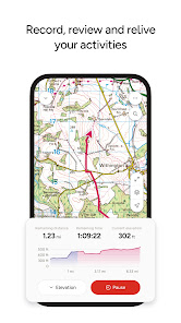
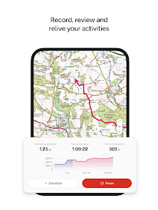
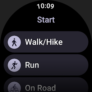
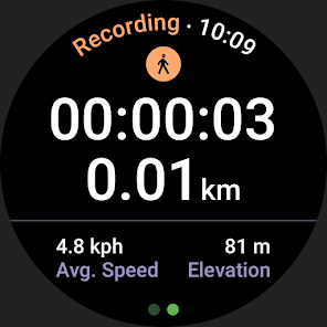
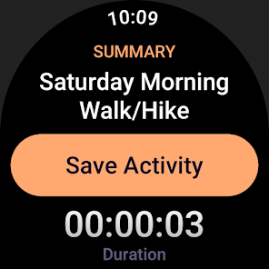
TRACK & RECORD ACTIVITIES
Use the activity recording feature to keep a log of your activity history. Follow along, save your activity, review it & turn it into a new route to share & follow again later.
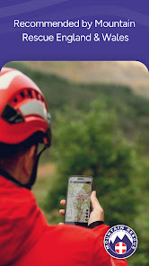
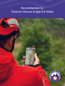
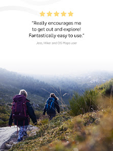
RECOMMENDED BY THE EXPERTS
Ordnance Survey is proud to partner with Mountain Rescue England & Wales, with OS Maps as their recommended app to help you keep on track, and keep safe when heading outside.
AWARD-WINNING MAP TECHNOLOGY
OS Maps has been voted The Great Outdoor App of the Year for 7 years in a row! Yahoo Sports Technology Awards Best App, Outdoor Industry Awards Digital Product of the Year & Singletrack Best Online Service.
USEFUL INFORMATION
Battery life can be dramatically decreased by using GPS constantly.
We release updates to all of our apps as we improve them, making them even more stable & adding extra features. Topographic mapping is available for UK (including Northern Ireland), USA, Australia & New Zealand. Your feedback & comments about those apps are really important to us. Leave a review or use os.uk/contact to get in touch.
Discover hiking routes, walking routes, cycling paths & so much more with the app that lets you explore the joy of the Great British countryside. Whether you want to hike, bike, run, ramble or walk - discover thousands of exciting maps & routes today!
Terms & Conditions at os.uk/termsosmaps
outdoors.
Why you’ll love using OS Maps:
EXPLORE & PLAN HIKES, RUNS OR RIDES
Whether you are planning a walk, hike, run or ride; OS Maps lets you create outdoor adventures with trusted mapping & navigation tools from the experts at Ordnance Survey, Britain’s national mapping service.
DISCOVER THOUSANDS OF READY-MADE ROUTES
Get outside with curated routes from outdoor experts & organisations such as Trail, Country Walking, Mountain Bike UK, BBC Countryfile and more.
ICONIC OS MAPPING
Subscribe to unlock the detail & accuracy of OS leisure maps including OS Explorer 1:25,000 & OS Landranger 1:50,000. And now with global mapping & topographic mapping for USA, Australia & New Zealand to keep you exploring all over the world.
CREATE YOUR OWN ADVENTURES
Best in class route planning & navigation tools mean you can get off the beaten track & explore with more freedom. Plan routes with quick & easy snap-to-path route plotting, then save & share with your friends to plan that next epic day in the outdoors.
NO SIGNAL? NO PROBLEM
Download maps & routes to your phone to view offline, so they’re ready, whenever & wherever you need them. View any part of GB even without signal and export to your GPS device.
UNLIMITED PRINTING
Print copies of all your routes & maps to take with you, so you always have a backup to hand.
USE ON EVERY DEVICE
Sync your activities between across devices, on desktop & mobile. On desktop, premium users can use our 3D Aerial Layer & route fly-throughs to see the landscape, terrain and explore in stunning 3D.
TRACK & RECORD ACTIVITIES
Use the activity recording feature to keep a log of your activity history. Follow along, save your activity, review it & turn it into a new route to share & follow again later.
RECOMMENDED BY THE EXPERTS
Ordnance Survey is proud to partner with Mountain Rescue England & Wales, with OS Maps as their recommended app to help you keep on track, and keep safe when heading outside.
AWARD-WINNING MAP TECHNOLOGY
OS Maps has been voted The Great Outdoor App of the Year for 7 years in a row! Yahoo Sports Technology Awards Best App, Outdoor Industry Awards Digital Product of the Year & Singletrack Best Online Service.
USEFUL INFORMATION
Battery life can be dramatically decreased by using GPS constantly.
We release updates to all of our apps as we improve them, making them even more stable & adding extra features. Topographic mapping is available for UK (including Northern Ireland), USA, Australia & New Zealand. Your feedback & comments about those apps are really important to us. Leave a review or use os.uk/contact to get in touch.
Discover hiking routes, walking routes, cycling paths & so much more with the app that lets you explore the joy of the Great British countryside. Whether you want to hike, bike, run, ramble or walk - discover thousands of exciting maps & routes today!
Terms & Conditions at os.uk/termsosmaps
Updated on
Safety starts with understanding how developers collect and share your data. Data privacy and security practices may vary based on your use, region, and age. The developer provided this information and may update it over time.


Ratings and reviews
4.4
18.2K reviews

Sara MacKenzie
- Flag inappropriate
Since the update it's been unreliable. Takes ages to load, even maps I've previously downloaded. They push user maps too hard without ways to filter them out or get rid of redundancies. If I'm out on the hills and want to see some trail options, I'll be there all day staring at a blank screen before realising the app has crashed again. Would prefer less options and a more functional app!
18 people found this review helpful

Iain Ward-Button
- Flag inappropriate
Not a fan, especially as it decides to randomly log me out whilst using the app. A bigger issue for me is that when I look at my route after I've been out, it looks like I've been through peoples houses! If I've walked in a straight line I would expect to see a straight line on the map. I can't believe the distance covered because of this and generally reduce it by 20% .
4 people found this review helpful

Jeff Fidler
- Flag inappropriate
Lots of bugs. The app always tells my my altitude is around 50M higher than it is. Other apps on the same phone get this right. The time a route is expected to take shown on the app is different to the same route on a PC (is it failing to take into account customised activity speeds?). A route that has been edited on the app still shows the old route image in the list of routes.
5 people found this review helpful
What's new
This latest release includes improvements to performance and introduces a map scale which can be seen in the bottom left when viewing the map.


